MV Sanderling has been sold

On January 14, 2021, Sanderling was turned over to her new owner who has taken her to a marina just over the Florida/Alabama boarder on the GICW.

We will continue to update our blog with information about trawlers and cruising in trawlers from time to time. Meanwhile, you might want to subscribe to the Trawlers-and-Trawlering email list (T&T List) to ask questions or learn more about boating from some very knowledgeable and experience people. You can subscribe to T&T List by sending an email to trawlers-join@lists.trawlering.com.

After almost 25 years, the Trawlers and Trawlering list is closing. You can download the archives from the T&T List here.

Underway Southbound – 2015

Southbound!

Follow us on MarineTraffic.com – just search for Sanderling and then select the pleasure boat registered in the United States.

September 21, 2015 (Monday)

Judy returned from Kansas on Thursday night, September 3rd, and Bob met her at the bus station in Portland after having dinner with Norm and Nancy at the Snow Squall Restaurant. On Friday we did some final shopping and prepared for our departure the next day. We did depart South Freeport on Saturday morning, September 5th, heading south and are now in a Navy-operated marina at Solomons, Maryland, having arrived here on Saturday, September 19th, two weeks to the day after departing South Freeport, Maine. We had dinner the last night with friends Norm and Nancy who were kind enough to meet us at the Enterprise Rental location in Portland on Friday afternoon, then drive us to Freeport where we had a great dinner together at the Tuscan Brick Oven Bistro – the pizza was super! Then Norm and Nancy drove us back to Straut’s Point Wharf marina where we said our goodbyes and dinghied back to Sanderling just before sunset. We departed South Freeport the next morning (Saturday),

September 5, 2015 (Saturday)

We dropped the lines to the mooring at 0625 and were underway – heading home! As much as we enjoy cruising in Maine, the weather was turning “fallish” and the temp this morning was 52F – too cold for our Florida blood. We cruised past Cliff Island and into the Atlantic Ocean, passed Cape Elizabeth at 0855 (Norm and Nancy’s summer home) and enjoyed a relatively calm day on the water with the sun shining, and at 1500 had our lines to the dock at the Portsmouth Naval Shipyard Marina Back Basin (actually in Kittery, Maine). We had quite a battle with the flood tide as we crabbed sideways into our assigned slip, but with the help of two other boaters were able to get the lines secured without difficulty.

Day: 58.4NM/67.1SM   –   8H35M
Trip: 2020.4NM/232.6SM   –   336H20M

While in Kittery we replenished our food stuffs from the small commissary, Bob took some photos of the now vacant former Navy prison (U.S. Naval Disciplinary Command, as it was known in the late 60s), and Judy ran five loads (small) of laundry through our onboard combination washer/dryer. The weather was pleasant with the sun shining every day and no fog!

On Monday, September 7, 2015, we cast off the lines at slack tide and made our way down the Piscataqua River and out into the Atlantic. Today we were heading around Cape Ann (since it was a holiday we didn’t want to risk tangling with “weekend” boaters in the Annisquam River/Canal) to Gloucester, where we are going to fill up with diesel fuel at about $2.00 per gallon! The ocean getting to Cape Ann was fairly smooth, but as we started to round Cape Ann the wind picked up from the south/south-west and the waves became a bit rough until we reached Gloucester Harbor. As we approached Gloucester, Judy contacted the Harbormaster’s office and got a mooring for the night. We decided to take the mooring while it was still available and get fuel early in the morning before departing, so at 1300 we picked up a mooring at the junction of the two channels into the eastern end of the harbor. We had dinner aboard and a relaxing evening.

Day: 37.2NM/42.7SM   –   5H55M
Trip: 2057.6NM/2364.4SM   –   342H15M

Tuesday, September 8, 2015, we left the mooring at 0715 to shift location to the fuel barge, filled with 202.4 gallons at $2.14 (with tax), and were on our way by 0755. We had a straight shot across Massachusetts Bay to Plymouth, Massachusetts (remember Plymouth Rock, such as it is), and the bay smoothed out about an hour out of Gloucester. As we approached Plymouth the weather forecast for the night was for very light winds from the south, so instead of going about four miles out of our way into Plymouth Harbor, we anchored in Warren Cove which is right on the coast a few miles east of Plymouth, in an area well protected from southerly winds. The night was quiet!

Day: 41.5NM/47.7SM   –   5H55M
Trip: 2099.1NM/2412.0SM   –   358H35M

The next morning, Wednesday, September 9, 2015, we timed out departure from Warren Cove to put us in the Cape Cod Canal with favorable current. We were underway at 0740 and at 0955 we entered the canal with the current which had turned westward at 0730. When we got to the Buzzards Bay (west) end of the canal we encountered 4-6 foot standing waves in the channel of the canal leading out into Buzzards Bay. The boat took water over the bow which was blown over the top of our bimini (which stands 15 feet above the water) even though we slowed down to the point of only going 6 knots through the water with the rapid current pushing us. It quickly became apparent that we couldn’t tolerate the hobby-horsing for long so we slowly worked our way over to the south side of the channel without broaching (turning sideways to the waves) and into some slightly less rough water (no standing waves) out of the channel. From there we were able to motor to the south a short distance to a channel running back east and from there to a small cove with some substantial unused moorings (Judy referred to them at “guest” moorings) that looked as though they hadn’t been used for awhile, and at 1155 had taken one. We decided to spend the night there and rest up from our ordeal in the canal. No one came out to ask us to move, and we had another peaceful night, out of the current and with only a little wind.

Day: 28.7NM/33.0SM   –  4H15M
Trip: 2127.8NM/2445.0SM   –   352H50M

We left the “guest” mooring at 0640 on Thursday, September 10, 2015, heading to Bristol, Rhode Island, for several nights to visit with friends Helga and Vic. The trip down Buzzards Bay was punctuated by fog, heavy rain with lightning and thunder, and some 3 foot waves during the rain storms, but we turned the corner into the Sakonnet River in the rain at 1120 and at 1415 had lines to a mooring at Bristol Marine, in Bristol, Rhode Island. Judy was amazed at the number of sailboats on moorings in Bristol Harbor; included were a number of Nathanial Herreshoff designs maintained in good shape by the owners who love them!

Day: 51.0NM/58.6SM   –   7H35M
Trip: 2178.8NM/2503.6SM   –   360H25M

We were in Bristol, RI, for two nights, and spent the day on Friday with friends Helga and Vic. With them we walked the grounds of Blithewold and they showed us the newly renovated Bristol Art Museum in which they had a major roll in arranging the long-term lease, soliciting major contributions and donors, meeting with architects, and doing a lot of the interior work. They have received a special award from Blithewold, and one of the galleries at the Art Museum is being named after them! We had an early dinner with Helga and Vic and two other friends from the 80s when Bob lived in Bristol, then Vic drove us back to the marina where we caught the last launch of the evening (around 1900) back to Sanderling.

Saturday morning, September 12, 2015, dawned overcast but calm, and we were underway at 0605 heading for the Long Island Sound. We turned out of Narragansett Bay rounding Point Judith at 0945, and at 1205 Watch Hill and it’s beautiful homes was to starboard as we entered Long Island Sound north of Fisher’s Island to avoid the higher tidal currents at the Race or at Plum Gut – the water was nonetheless turbulent as we crossed the boundary between ocean and sound. We continued westward along the north shore of the Sound to Duck Island about four miles west of the Connecticut Rive along the north shore of the Sound. Duck Island is a very small island with long breakwaters extending from the island to the west and to the north, making a good anchorage when then wind is from the east or south. The NOAA forecast for Saturday night was for winds 10-15 MPH from the southeast, so this was an ideal spot. When we arrived at 1730 there were four sailboats and three power boats anchored in various locations in the protected area. We picked a good spot with plenty of swinging room in 8 feet of water and let out 125 feet of chain; we backed down at 1200 rpm to make sure the anchor was holding well.

Day: 74.4NM/85.5SM   –  11H25M
Trip: 2253.2NM/2589.1SM   –   372H10M

As the afternoon turned to evening several boats departed the area as the wind (and waves) increased. By 2000 it was apparent that NOAA and the other weather services had badly misjudged the wind on the Sound, although it continued out of the southeast and later from the east. Here’s what Judy wrote in the log about our experience that night:

What a night! The weather folks, including NOA really missed this one! Winds were predicted 10-15 with gusts to 20 [MPH] – we had steady winds of 30-35 for about 6 hours! Anchor alarm was sounding [GPS location issue], winds were terribly loud, boat was swinging, cats were scared, sailboat next to us had sail come loose at 0200 in the morning! Bob got about 4 hours of sleep; Judy got about 2! Wild night!

The wind started slacking about 0400 (I think that’s when Judy went to bed for some much needed sleep) and by 0700 they were still gusting in the 20s, but but 0800 they had slacked even more. The anchor was really buried in mud/sand and we had to use the boat’s forward momentum to break it loose as the windlass couldn’t pull it out without help.

We were underway at 0805, Sunday, September 13, heading across the Sound and to the west to Port Washington. The wind continued from the east as did the tidal current for a good part of the day, so we made some good time. As we approached Fort Washington/Manhasset Bay the current turned against us and with the easterly wind the water again became rough and we slowed down a bit. We had our lines to one of the 18 free-for-two-days moorings in Manhasset Bay at 1825.

Day: 67.4NM/77.4SM   –   10H20M
Trip: 2320.6NM/2666.6SM   –   382H30M

Weather in the New York/Long Island area was poor on Monday (windy), so we stayed the day on the mooring. Later in the afternoon we took the water taxi to Port Washington and ate an early dinner at Diwan, a great Indian restaurant recommended by the water taxi driver. After dinner we got a few items at a nearby grocery store and then hailed the taxi by VHF radio for a ride back to Sanderling.

Port Washington mooring field

Port Washington mooring field

Tuesday, September 15th we were underway at 1045 in order to catch the fair ebb current at 1130 on the East River through New York City. Interestingly, although Long Island Sound and the East River are connected, Long Island Sound floods from east to west and the East River floods from west to east – the flood tides meet on the western end of Long Island Sound and the tide charts actually have current arrows pointing at each other in the area in the area between Frogs Neck and Manhasset Bay! Ebb tide is just the opposite in the two bodies of water.

We were traveling at 9.1 knots through Hell Gate (not bad considering that the current alone can reach 6 knots) and shot under the Brooklyn Bridge at 1325 and under the Verrazano Narrows Bridge at 1415. We continued south out of New York Harbor and anchored on the west side of Sandy Hook just north of the Coast Guard station at 1535. The night was quiet!

Day: 33.4NM/38.4SM   –   4H50M
Trip: 2354.0NM/2704.9SM   –   387H20M

The next four days were a race to get to Solomons, Maryland, before forecast winds with gusts near 30 from the north started on Sunday. So we were underway before we could see the surface of the water at 0545 on Wednesday, September 16, following the “bread-crumb” trail on the chart plotter out of the anchorage and around the western side of Sandy Hook. By the time we reached the northern side we could see the water and make out the navigation aids without the help of a spot light. We ran down the east coast of New Jersey to Atlantic City where we tied to the dock at Gardners Basin and went ashore to eat dinner at the Back Bay Ale House, filled the water tanks, had a good night’s sleep, and were underway at 0655 on Thursday. As we were getting ready to cast off lines, we discovered that our bow line had been cut with a knife during the night and was dangling in the water; fortunately our spring lines were holding us in place as the large clam boats passed on their way out to vacuum the bottom for clams! In the six times we’ve stayed at Gardners Basin, this is the first time that we’ve experienced any sort of vandalism – it’s hard to tell if it occurred from someone on the dock or in a small boat. The line was definitely cut with a rather dull knife!

By the time we reached Cape May we decided we’d continue on into Delaware Bay and find an anchorage along the north shore south of the nuclear power plant. We exited the Cape May Canal into Delaware Bay at 1305 and anchored at Cohansey Cove at 1815 in 11 feet of water. The current from the Cohansey River was causing the water in the area to move rather quickly into the Bay, and I misjudged the speed at which we were backing when we set the anchor. Consequently, the anchor chain snapped tight as the anchor held firm (very unusual) and the block supporting the anchor chain stopper cracked near the base between two layers of wood and fiberglass. Not a catastrophy, but another repair to think about.

Here’s what I wrote in the log about the night at Cohansey River entrance:

Terrible night with wave induced rolling along with 15 MPH wind from the south until after mid-night, then continuing with only 2 short periods of sleep! Tide and river current interaction?

We were underway at 0625 on Friday, September 18th, after again having to use forward motion of the boat to free the anchor – it was buried deep in mud (guess that’s why it held so quickly when anchoring). The current on Delaware Bay was against us and we were making only 4.5-5.0 knots most of the way to the Chesapeake and Delaware Canal, then the current in the canal was against us as well. When we entered the canal at Reedy Point Judy spotted an eagle perched on a short tower. We followed a sailboat who seemed to know what he was doing along the northern bank of the canal, and found that the current was about 0.4 knots less close to the bank – a good trick to keep in mind in the future. We exited the canal at 1310 and anchored in Bodkin Bay (just off the southern shipping channel into Baltimore) at 1620 in a beautiful, quiet location.

Day: 71.8NM/82.5SM   –   11H55M
Trip: 2575.9NM/2955.9SM   –   422H20M

When we awoke on Saturday morning, September 19, 2015, the fog had descended. Nothing as thick as we experienced in Maine, and it soon lifted enough that we could see several other boats anchored nearby and eventually the shoreline about 1/4 mile away. We were underway at 0735, under the Annapolis Bay Bridge at 0920, turned into the Patuxent River at 1455 at Cove Point, and had our lines to the dock at Point patience Marina (Navy Recreation Center, Solomons) at 1615. We’re going to stay here for a few days while Judy drive home for some professional meetings and to work at “her” hospital. Bob is going to work on boat projects and take care of the cats!

Day: 54.8NM/63.0SM   –   8H40M
Trip: 2630.7NM/3022.9SM   –   431H00M

We had dinner on Sunday evening with Jennifer and Don from Edgewater at the CD Cafe – one of our favorites in this area! They departed shortly after dinner as they both teach the next day in high schools south of Annapolis.

Judy picked up a rental car from Enterprise in Lexington Park on Monday morning, we did some quick shopping, and then around noon she headed south to Florida.

While Judy was in Florida, Bob worked on maintenance items and had dinner on the following Saturday with Jennifer and Don. We ate at Stoney’s Kingfisher restaurant and I had “original” crab cakes. They were just as good as I remembered; this is the only place I get crab cakes on the east coast – nowhere else compares!

Judy returned from Florida on Sunday evening. While she still had the rental car we did some last minute grocery shopping. On Monday she turned in the rental car, then we got Sanderling ready to get underway, filled the water tanks, and ate dinner with dock friends at Boomerang’s Restaurant – good burgers and ribs.

The weather forecast for Chesapeake Bay for the next two days was decent; by Wednesday evening the weather was deteriorating – waves on the lower Chesapeake and Hampton Roads were forecast to reach 5-6 feet on Thursday – not a day we would want to be crossing into Norfolk from any anchorage on the northern side of the area. Our goal was to be through Hampton Roads and into Norfolk and into a protected anchorage by Wednesday afternoon.

On Tuesday, September 29, 2015 we were underway from Point Patience Marina at 0635, headed out the Patuxent River, and turned south into Chesapeake Bay. The tidal current was with us and we made good time; even the 15 mile leg from Point No Point Light to Smith Point Light (across the mouth of the Potomac River) was relatively calm. Once we had Smith Point Light abeam the waves picked up to 2-3 feet from the south-east, and the ride from there to the Piankatank River (Stingray Point) was rough; we had to tack back and forth to lessen the impact of the waves which resulted in a much longer leg than originally planned. We anchored in the rain in Godfrey Bay on the south side of the Piankatank River at 1630, with some protection from the waves and the main body of Chesapeake Bay. After a few hours the smaller wind generated waves died down and the rest of the evening and night were quiet and pleasant.

Day: 62.0NM/71.2SM   –   9H55M         Trip: 2692.7NM/3094.1SM   –   40H55M

Wednesday, September 30th, dawned overcast so it wasn’t as light as early as we had hoped. We got underway in the dark at 0630, with Judy following our “bread crumbs” on the chart plotter from our entrance into the river the day before. Several other boats were leaving the river at about the same time, so we had a small procession heading back into Chesapeake Bay and turning south toward Norfolk and Hampton Roads, about 35 miles away. We had planned a route into a small anchorage in the Lafayette River, just south of the naval base, as a good place to stop for the day (and get off the Bay), but with a nice push from the ebb tide for the first couple of hours and a boost in our engine’s RPMs we made good time down the Bay. By 1000 it was apparent that we could get further than planned, and we extended our route into the Dismal Swamp Canal. We were also getting weather forecasts discussing hurricane Joaquin, so we wanted to get not just to a protected anchorage but into a good hurricane hole in case Joaquin developed into a major threat or even if he dwindled into a bad nor’easter. Elizabeth’s Dock in the Dismal Swamp Canal became our goal.

We passed Old Point Comfort and entered Hampton Roads at 1215 after having a foul tidal current for several hours. The chart plotter showed that we should be at the mouth of the small river leading to the Dismal Swamp Canal (Deep Creek Lock) at 1500 – the last lock up for the day is at 1530, so we would have to run the three miles up Deep Creek in 30 minutes – should be plenty of time. And we did. We got to the junction of the ICW and Deep Creek at 1500 after sailing through Norfolk with no delays for bridges (most low bridges have been replaced with high bridges, except for the three railway bridges), turned into the creek, and arrived at Deep Creek Lock at 1520! The lock tender was cutting the grass at the lock so didn’t get to us until about 1530, then had to lower the water in the lock. By the time we entered the lock, chatted with Robert, exited, and hung a sharp right we had our lines to Elizabeth’s Dock at 1610.

Day: 58.7NM/67.55SM   –   9H00M      Trip: 2751.4NM/3161.5SM   –   449H55M

We will be staying here at Elizabeth’s Dock for a few days until hurricane Joaquin gets sorted out. A large sailing cat came into the canal and moored to the dock at 1130, and it sounds like two more sailboats are currently entering the lock and have asked about mooring at the dock. We’ll soon have a storm party!

October 5, 2015 (Monday)

After five days at Elizabeth’s Dock at Deep Creek Lock in the north end of the Dismal Swamp Canal, the winds are finally slowly abating and Wednesday looks like a good day to cross Albermarle Sound. We’re going to depart the dock tomorrow morning (Tuesday) at around 0900 and continue south through the canal and out at South Mills; then we’ll anchor in the Pasquotank River north of Elizabeth City for the afternoon and evening. We hope the forecast holds true; by Wednesday the wind should be out of the north at 10-15 MPH and conditions on Albermarle Sound should be conducive to a decent crossing into the Alligator River where we’ll anchor for the night just before entering the Alligator-Pungo Canal. We’ll stop for fuel the following day (Thursday) at Dowry Creek Marina on the Pungo River just east of Bellehaven, then go a little further and anchor for the night, again. With any luck the various rivers and sounds we have to transit for the rest of the week will be gentle and allow an uneventful passage.

October 12, 2015 (Monday)

Here’s where we’ve been for the past week:

Tuesday, October 6th, departed Dismal Swamp Canal and anchored for the night at Goat Island in the Pasquotank River.

Wednesday, October 7th, finished the Pasquotank River past Elizabeth City, NC, and across Albermarle Sound (fairly calm) to anchor for the night near Tuckahoe Point, just before the Alligator-Pungo Canal.

Alligator River Deep Point anchorage

Alligator River Deep Point anchorage


Thursday, October 8th, transited the Alligator-Pungo C

anal into the Pungo River, stopped at Dowrey Creek Marina for 254 gallons of diesel fuel (no water available because their well had flooded with all the recent rain), then continued on a short distance and anchored in Pungo Creek for the night.

Washington NC free town dock

Washington NC free town dock

Friday, October 9th, finished the Pungo River and entered the Pamlico River where we turned westward and cruised the 30 miles upstream to Washington, North Carolina (Little Washington), where we filled the water tanks at the “shopping dock” at no charge, then were directed to a 48-hour free dock a short distance away. Had a nice time in this quaint little town incorporated in 1776 (the first town in the US named after George Washington). Had the best shrimp and grits at a nearby restaurant (perhaps second to Bob’s very own). We stayed for two nights.

Sunday, October 11th, returned the 30 miles back down the Pamlico River and resumed the ICW track into Goose Creek where we anchored in Campbell Creek for the night.

Oriental NC Town Dock

Oriental NC Town Dock

Monday, October 12th, finished Goose Creek past the Coast Guard station and fishing boats, then into the Neuse River (got a little rough with following seas blown by 15 MPH winds from the NE out of Pamlico Sound). Continued up the Neuse to Oriental where, for the first time in eight or so visits, we were able to get a spot on the free town dock (free for 48 hours). Ernie (the young cat) had a cut that required the attention of a veterinarian, so Judy took him to one just two blocks from the town dock (this is a very small town, pop. 900); the cut required stitches to close, and we had Ernie back by mid afternoon, thanks to vet Sherri Hicks. Ernie is groggy and wearing a collar – you can only imagine how much he hates that!

Tomorrow, Tuesday, we’ll head to Morehead City/Beaufort and then west toward Camp Lejeune and Mile Hammock Bay where we’ll anchor for the night. OR, we’ll stop in Morehead City at the Sanitary Seafood Company dock and have dinner there, then head to Mile Hammock Bay the next day.

Water from the recent storms is still causing flooding in some of the rivers in South Carolina so we’re taking our time getting there. Forecasts indicate the water should be back to near normal by Thursday this week.

All is well!

Posted October 18, 2015

Ernie is almost back to his normal, rambunctious self (except for the shaved area on his butt where the hair is slowly growing out).

Cedar Creek

Cedar Creek

We left Oriental on Tuesday, October 13th as planned, at 0915 but only went as far as Cedar Creek (MM 187.7), about 8.3SM/7.2NM, where we anchored at 1030. We were able to anchor mostly out of the SW winds so had a fairly calm day at anchor catching up on work and reading. Ernie wore his collar at night, only, and kept Judy awake for a good part of the night dealing with his collar. During the evening the wind subsided and the forecast for Bogue Sound for the next day was good.

Day: 8.3SM/7.2NM – 1H15M      Trip: 2972.6NM/3415.7SM – 493H30M

We were underway from Cedar Creek (MM187.7) at 0735, Wednesday, October 14th, rounded the bulkhead at Morehead City (next to Beaufort) at 10:15, and turned into Bogue Sound. The dock at the Sanitary Fish Company had only one sailboat, but we decided to keep going since the Sound was fairly peaceful and we wanted to get further along our route south. Bogue Sound turned out to be a great transit; the wind and water were calm, and there were very few boats moving in our direction. We did pass several small working boats dragging nets in the channel, but they moved off to the side to let us pass. We anchored in Mile Hammock Bay at Camp LeJeune, North Carolina, just off the ICW, at 1550. During the rest of the afternoon we were joined by two other power boats (a trawler and a beautiful Legacy MK3 tug) and four sailboats (including Toby with CJ aboard with whom we shared the town dock at Oriental).

Day: 66.5SM/57.9NM – 8H15M    Trip: 3030.4NM/3482.2SM – 493H30M

We were underway at 0735, October 15, 2015, from Mile Hammock Bay (MM244.5), went through two bridges with minimal delays waiting for openings, then arrived at the Wrightsville Beach Bridge where the bridge tender would not open even three minutes past the normal on-the-hour opening at 1300 to let us and Second Option (a sailboat from Mile Hammock Bay the night before) get through – so we waited – and talked from boat to boat – and about 1330 a southbound commercial tug called the bridge for an opening. We hadn’t been able to identify the tug visually, but as soon as we heard it call the bridge we looked again, and sure enough, there was a small tug pushing what appeared to be a LCM – so we were able to join the parade and pass through the bridge at 1335 (25 minutes earlier than the “normal” bridge opening). We followed the tug (and Second Option) through the shallow spots between Wrightsville Beach and Snows Cut, with the tug grounding several times while leading the way and “dredging” the shallows! Just before Snows Cut, which leads to the Cape Fear River, we turned off into Carolina Beach and took a mooring ball at 1530. Second Option got to a mooring ball a few minutes earlier.

Day: 51.1SM/44.5NM – 7H55M     Trip: 3074.9NM/3533.3SM – 501H25M

From Carolina Beach mooring field it was a short trip through Snows Cut, down the Cape Fear River to Southport, then a short distance to the South Harbor Village Marina at MM 311. We had dinner at a nice Italian Restaurant (others would describe it as “excellent” but I’m not a big fan of Italian food, other than pizza) with Bill and Terri from Second Option.

Day: 16.9SM/14.7NM – 2H45M   Trip: 3089.6NM/3550.2SM – 504H10M

Today’s weather was questionable when we arrived at the marina, but we decided to wait until we awoke in this morning to decide whether to stay a second night at the marina – we’re glad we waited to decide; overnight the forecast changed from high, gusting winds, to fairly calm conditions on the ICW.

Barefoot Landing Marina,Myrtle Beach, SC

Barefoot Landing Marina,Myrtle Beach, SC

We were underway at 0730, October 17th, from the South Harbor Village Marina (MM 311.1), at 0835 we transited Lockwood Folly at mid-flood tide and saw no less than 8.7 feet of water depth. This is an area of shifting shoals with temporary buoys placed to help guide boats through the hazards. At 1330 we had our lines to the dock at Barefoot Landing Marina with the help of Nick, Bruce, and Jordan, where we are staying for two nights in order to do some grocery shopping and change the engine oil. This is a nice stop with a good variety of restaurants to choose from, and interesting people-watching among the crowds from the Myrtle Beach area who seem to frequent the Barefoot Landing shopping/entertainment area. Bruce gave us tickets for House of Blues where we heard a Bon Jovi tribute group playing to an enthusiastic crowd!

Day: 42.7SM/37.2NM – 6H00M   Trip: 3126.8NM/3592.9SM – 510H10M

Posted October 31, 2015

A quick summary of the past two weeks since Barefoot Landing Marina

Departed Barefoot Landing Marina on October 20, 2015; anchored in South Santee River (west branch) MM415.

Departed South Santee River on Wednesday, October 21st; anchored Church Creek (south of Charleston) at MM487

Departed Church Creek on Thursday, October 22, 2015; anchored Bull Creek (by Dufusky Island and south of Beaufort, SC) at MM566

Departed Bull Creek on Friday, October 23, 2015; anchored Walburg Creek (immediately off St. Catherine Sound) at MM619

Departed Walburg Creek on Saturday, October 24, 2015: anchored at Wallys Leg MM666.2

Departed Wallys Leg on Sunday, October 24, 2015; anchored Little Cumberland Island (west side) at MM693.3

Departed Little Cumberland Island on Monday, October 26, 2015; took a mooring ball at Fernandina Beach (just south of the Florida/Georgia border) at MM717

Judy drove home and to Orlando in a rental car for meetings; returned on Wednesday, October 28th

Departed Fernandina, Florida, on Thursday, October 29, 2015; took mooring ball at St. Augustine at MM777.9

Departed St. Augustine on Friday, October 30, 2015; anchored in north end of Mosquito Lagoon at MM862 (a long day – almost 12 hours underway)

Departed Mosquito Lagoon on Saturday, October 31, 2015; anchored in the Banana River just west of Port Canaveral at what would be MM902 except we’re no longer on the ICW.

Tomorrow we have about 15 miles to go to reach Manatee Cove Marina; we anticipate arriving around noon. It will take us most of the afternoon to get essentials from the boat to our home and get our home back in semi-living condition.

Underway Northbound -2015

2015-06-14 Sunday

After four months in the boat yard and almost two weeks getting things ship-shape (at least good enough), loading supplies and purchasing food, we cast off lines at 1415 Sunday, June 14, 2015, on our way toward Maine. Whether we make it that far with this late start only time will tell, but at least we’re going to make the effort. This will be our 13th transit of the Atlantic Intracoastal Waterway (ICW) so there’s not much we have to stop for on the way north; perhaps we’ll take more time when we head back south.

In the meantime, we’ll try to keep this blog up to date as much as possible (whenever we have a decent internet connection and time permits). For now, we anchored the first night out just south of the NASA railroad bridge near Titusville, and anchored the second night north of SeaBreeze Bridge in Daytona. We stopped short today so we could visit and have dinner with our friend who lives in Palm Coast – staying the night at Marineland Marina between Palm Coast and St. Augustine. Tomorrow we’ll continue heading north through St. Augustine and will probably anchor at Pine Island.

2015-06-23 Tuesday

Have a chance to update the blog. We went into Barefoot Landing Marina in North Myrtle Beach late yesterday afternoon and have a good WiFi connection via our antenna and router, so will do what I have time for before getting to work.

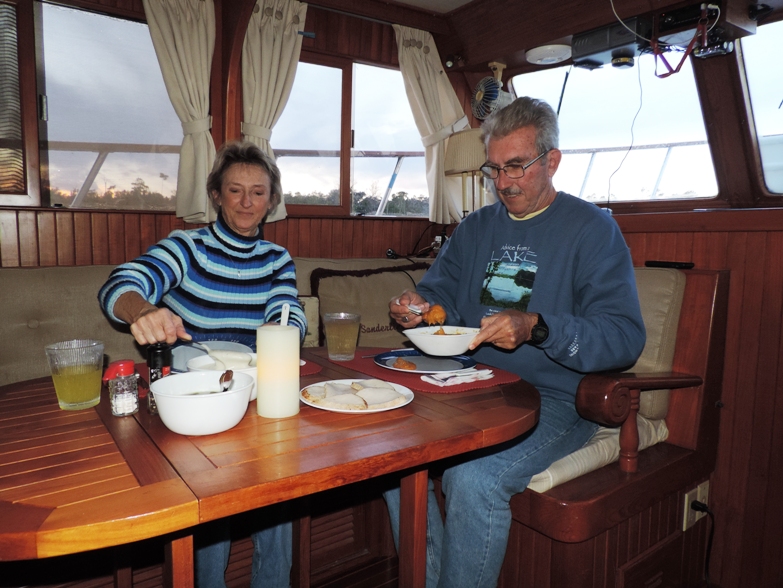
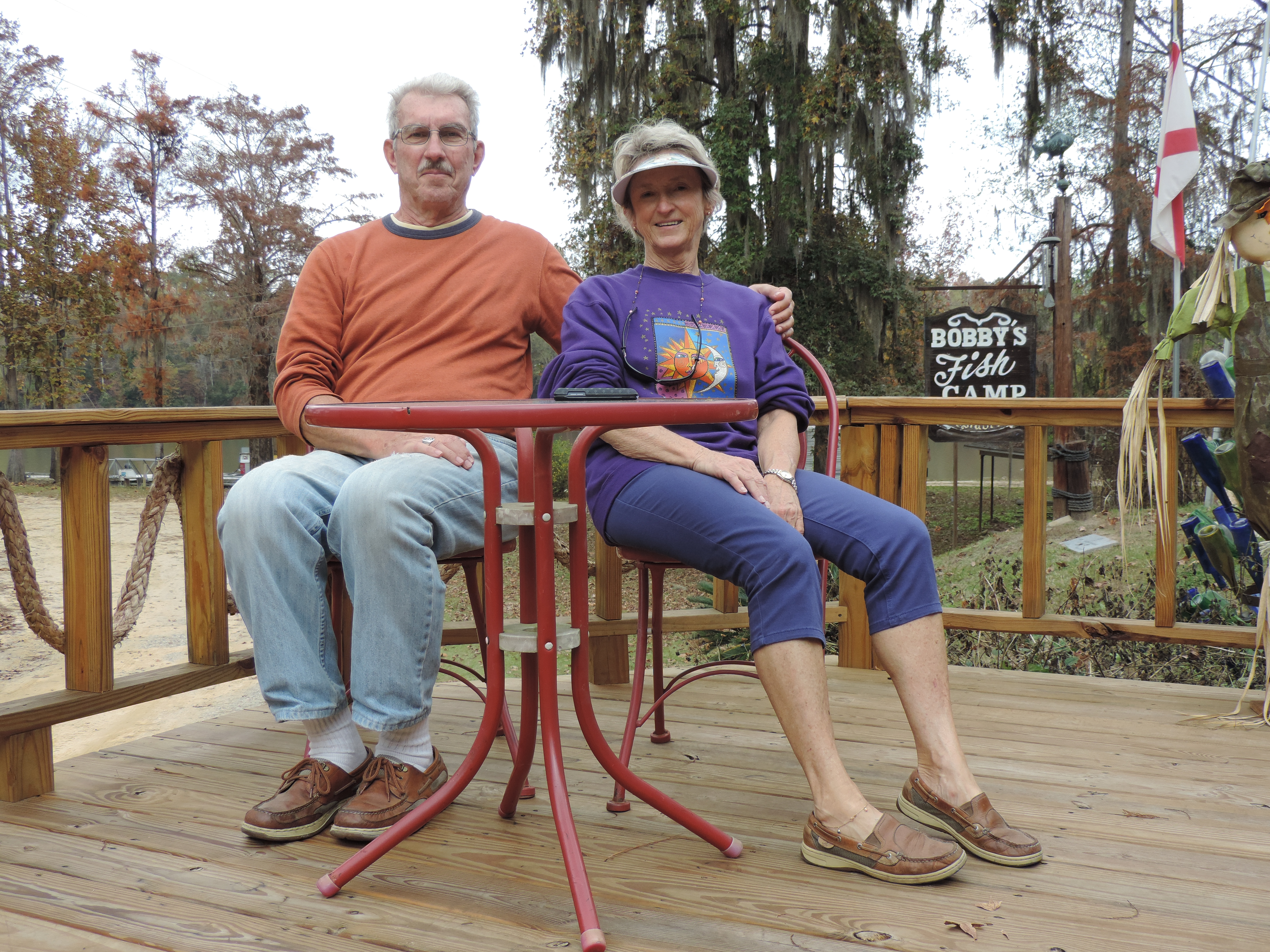
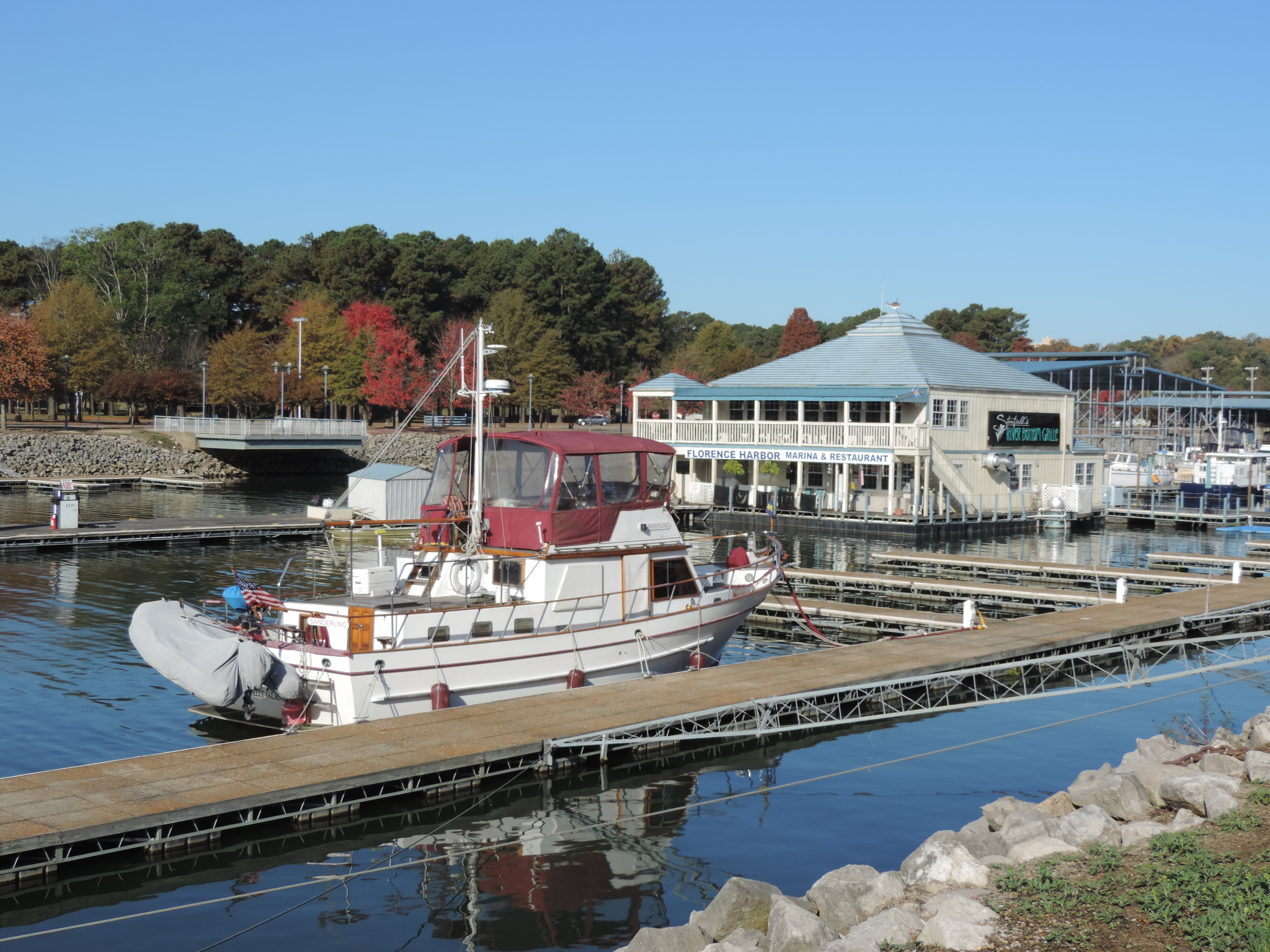
After leaving MCM, we anchored for the night just south of the NASA Railway bridge on the Indian River for the night. The next day, Monday, June 15th, we were underway at 0725 (the day was already hot) and anchoredat 1440 that afternoon at SeaBreeze Bridge in Daytona Beach, Florida. Had a quiet night with only one other boat coming into the anchorage. We had arranged to meet a friend from Palm Coast on Tuesday evening for dinner, so we were cutting our cruising days short so as not to arrive early. On Tuesday morning we were underway at 0730 and had lines to the dock at Marineland Marina by 1215, a cruise of only 32.9 miles and 4H45M! The air conditioning felt good after the heat of the last three days. We met Melissa (who presented us with various 30 amp and 50 amp electrical cords and a folding bike from her boating days on MV Fullstep) and then we went to an early dinner at a restaurant about five miles south of the marina (the only problem with Marineland Marina is that there are absolutely no facilities close at hand).

On Wednesday morning we were ready to move out. We departed Marineland Marina at 0650, transited St. Augustine (where we saw the Spanish Galeon Andalucia at the new docks) just south of the Bridge of Lions), crossed the St. Johns River at 1410, and at 1830 anchored at Cumberland Island, Georgia (mile marker 711), for a 90.2 mile , 11H40M, day!

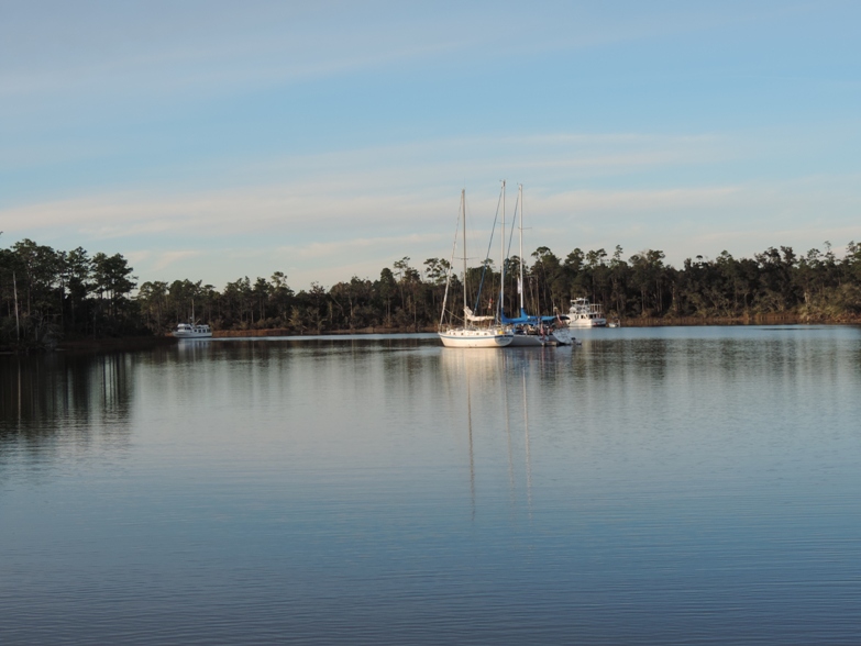
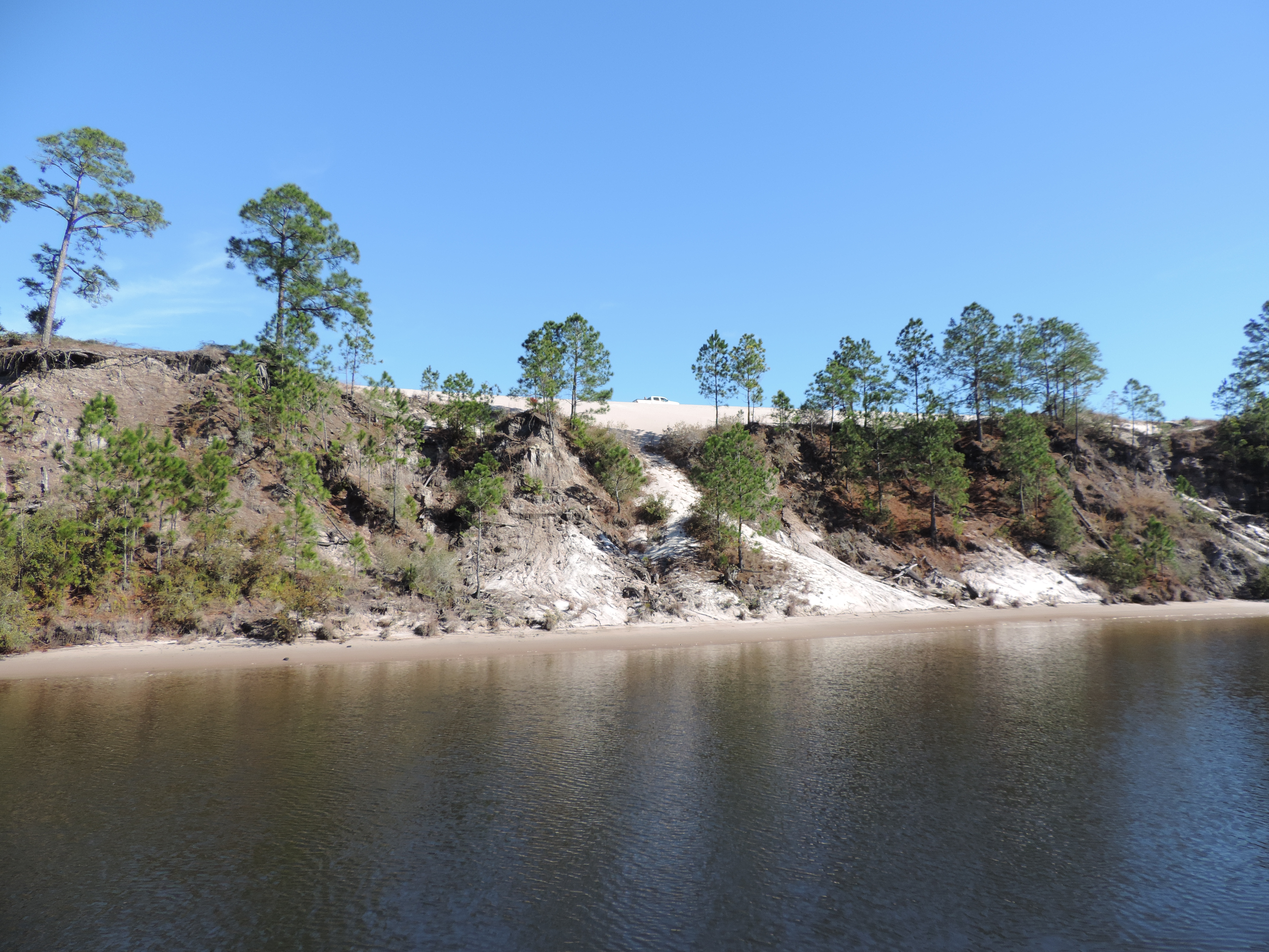
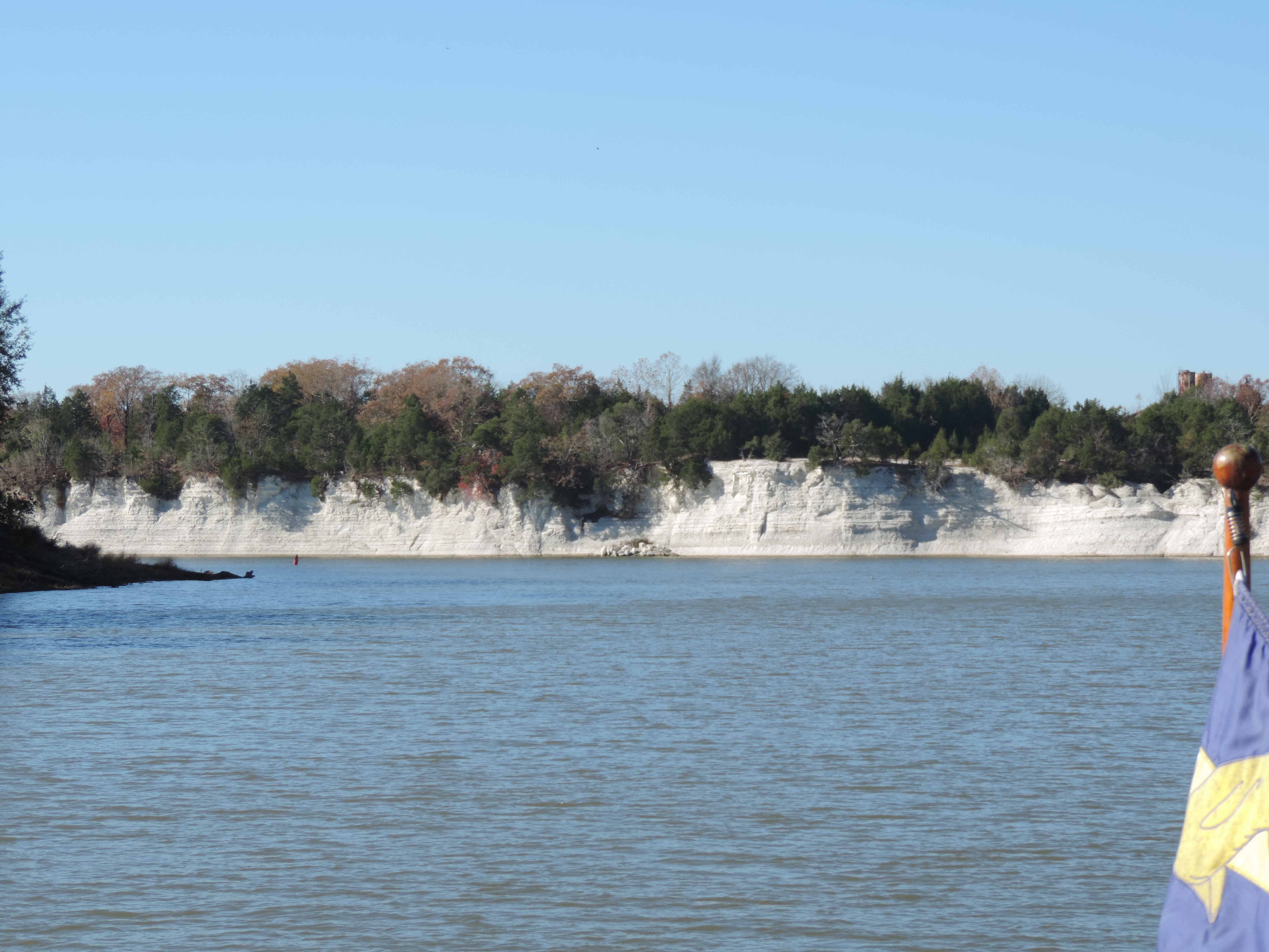
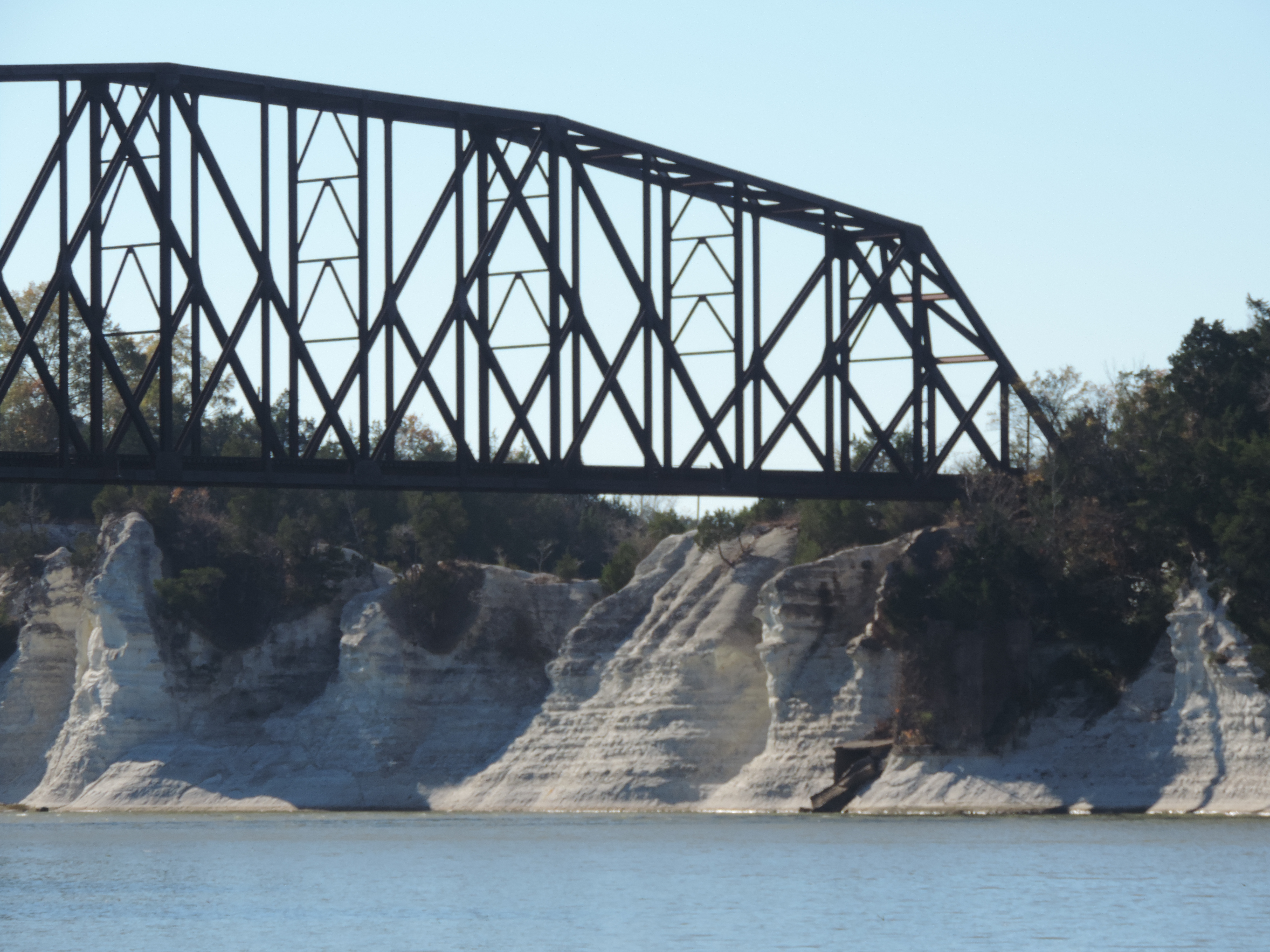
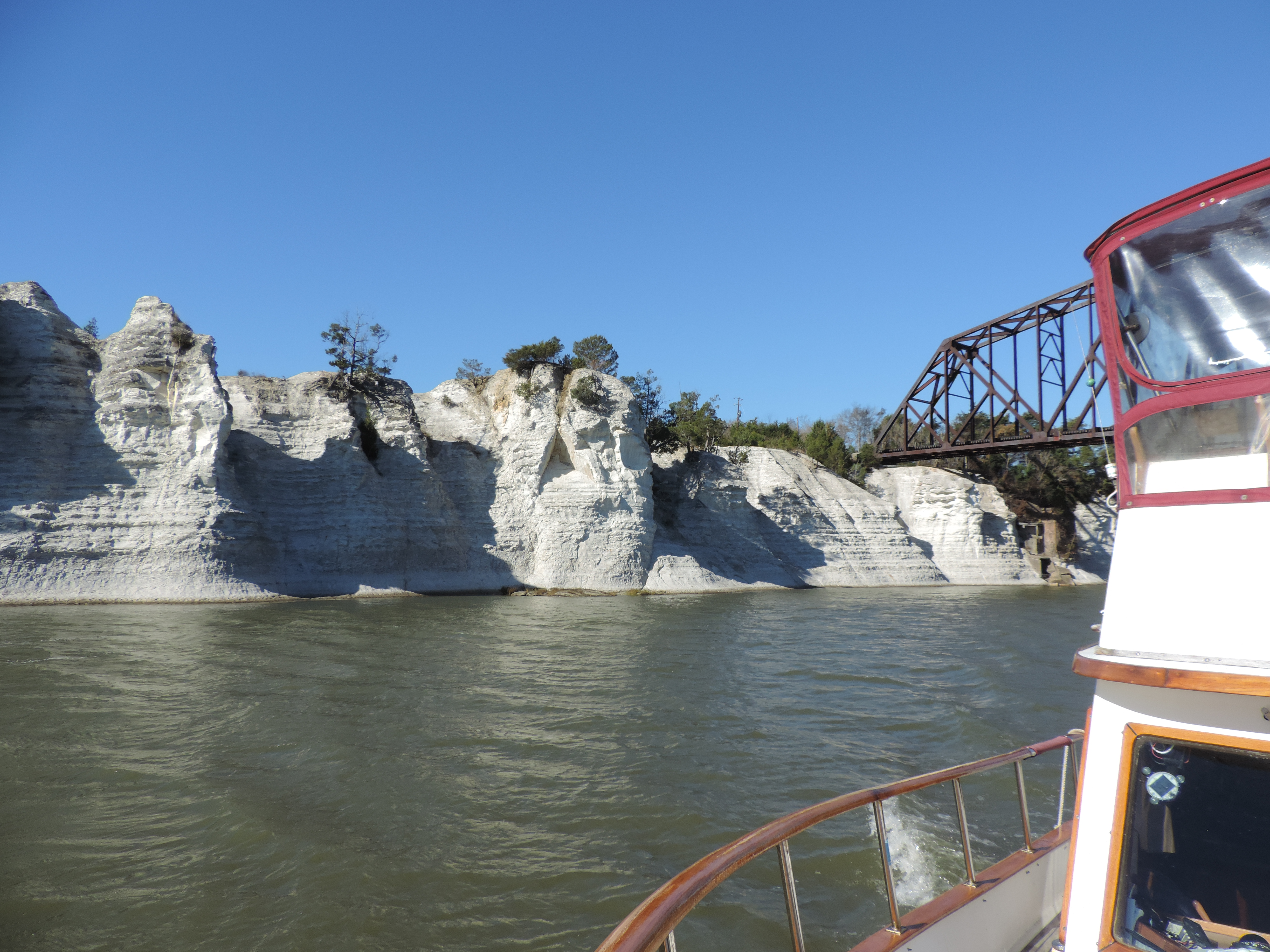
On Thursday morning we were underway at 0720, overtook a “dredge train” with tug Rachael leading dredge Brunswick and tug George, passed through Little Mud River at near low tide where we saw a depth of 4.9 feet (mud bottom), and anchored at 1740 in Crescent River at mile marker 643.Had a very pleasant evening (although it was hot, with a nice breeze) and observed a brilliant moon, Jupiter and Venus in the same section of the sky just after sunset.

On Friday (June 19th) we were again underway at 0720, crossed the Savannah River into South Carolina after passing the same “dredge train” at Thunderbolt, Georgia, and anchored at Bull Creek (MM 565) at 1825, after a 78.6 mile, 11H05M, day! Since it was Friday, we grilled hamburgers for dinner!

The next day, Saturday, we were underway at 0715 and anchored in Church Creek (mm 488) at 1730, along with another DeFever trawler (this one heading to St. Petersburg, Florida.

On Sunday morning while doing a getting underway engine room check, I heard a drip-drip-dripping sound occurring about 3-4 times per second. No little aquatic animals nibbling at the hull, no leaking fuel – it was raw (outside) water leaking from a pipe on the engine heat exchanger. After checking the easy source first (a rubber hose) it was obvious that the leak was in the pipe itself. I wrapped it tightly with emergency tape (self-amalgamating tape), replaced the hose leading to the transmission oil cooler, and tested my handy work by running the engine and observing – no more leak! Even with that work we got underway at 0740. A check of the engine room about an hour later revealed no further leak, so we continued on through Charleston, South Carolina, past Mt. Pleasant and Isle of Palms, and anchored in South Santee River (mm420) at 1650 after 67.7 miles and 9H10M. It was unbelievably hot so we started the generator and then the two air conditioners; a short time later Judy said she smelled diesel fuel (her “smeller” is much more sensitive than mine) and when I checked the engine room the generator was leaking diesel fuel at the fuel filter/water separator housing. When I tightened the nylon plug less than a 12th of a turn, the plug snapped off at the base of the nut and fuel spurted out! Emergency generator shutdown, mop up diesel fuel (only a small amount), open windows, suffer with the heat!

Monday morning we were underway at 0620. On Sunday we had made reservations for two nights in a very nice marina in North Myrtle Beach anticipating a stop to take delivery of a new heat exchanger sent overnight FedEx on Monday from American Diesel in Virginia, install the new heat exchanger, and spend a cool night with the air conditioners running. Now it became a place to replace the heat exchanger and try to repair the leak in the generator. Shortly before we arrived at the marina we heard a loud pop and couldn’t determine what had happened – nothing had fallen from the mast, nothing seemed amis. Then Judy smelled propane and heard a hissing sound – it took us about 5 nanoseconds to determine that the propane line between the tank and the regulator had broken – and it took another 20 nanoseconds to turn off the propane. Now we had a third thing to fix in the marina (if we could find a new propane line). We arrived at Barefoot Landing Marina (MM 353) at 1630 after delaying an hour for a rather severe thunderstorm with high winds to pass to the west of us – it never came far enough east to be of any concern. It was nice to have air conditioning, get off the boat, walk around, and enjoy a meal ashore (we ate at Joe’s Crab Shack), oh yes, and have some ice cream!

On Tuesday the marina manager drove us to three different locations to shop for boat parts and a few groceries. The heat exchanger was delivered by FedEx before we left for shopping. By the time we returned it was too late to change out the heat exchanger, but I was able to fix the fuel leak in the generator (I hope), and replaced the  propane tank hose. The heat exchanger can wait until the next marina1

Tomorrow (Wednesday) we head out again and probably won’t stop until we make a short stop for groceries at the northern end of the Dismal Swamp Canal in Virginia.

 June 27, 2015 (Saturday)

A quick update while we have some surreptitious WiFi!

After Barefoot Landing for two days (where we were able to do some grocery shopping, I got the propane line part and fixed the generator so we can have air conditioning), we made good time northward. First night at Caroline Beach, North Carolina (just north of the Cape Fear River) at mile 295, then Mile Hammock Bay at Marine Corps Base, Camp LeJeune, NC, at mile 244, (where we stayed two nights to wait for better weather on Bogue Sound and also to allow Judy to put in a full day’s work on a case she had with a deadline), and today to an anchorage just off the Neuse River in South River (and a little creek off South River) mile 178. Storms with high winds are predicted for tonight and part of tomorrow, so we wanted a good anchorage with a lot of protection from the wind from the southwest, and this looked like just the place. We pulled into the little creek in a torrential downpour, but it soon let up and Judy was able to work the anchor windlass from the foredeck to get town 75 feet of chain in seven feet of water! We backed down on the anchor at 1200 rpm and we held firm – that should hold us through the forecast 40 knots of wind!

Only time will tell whether the storm materializes tonight, but the weather forecasts for this area for the past several days have been quite accurate, so we’re planning on rain and wind with gusts to around 40 tonight. Will let you know next time I’m able to update the blog

The first morning we were at Mile Hammock Bay we alerted the Coast Guard to a small skiff calling for help over the VHF. We could hear them, but apparently the Coast Guard could not, and after several attempt to establish a location for their boat via VHF, Judy called the Coast Guard using her cell phone. Shortly after that the Coast Guard attempted to contact the boat, but for whatever reason the boat wasn’t responsive but yet still continued calls for assistance at short intervals. The boat indicated they had taken on water in New River Inlet (just south of Camp LeJeune) and needed help. Hard to tell whether a call like that is a hoax or the real thing, but later in the morning the Coast Guard called Judy’s cell and informed her that SeaTow had found the boat full of water and washed up ashore and that everyone aboard was safe – they thanked Judy for her assistance. Nice work!

Just checked the weather forecast and WindGuru and while there are storms in the area the wind forecast isn’t as severe as it was four hours ago – now forecast to be SW with gusts to around 28! Much better than 40! And the wind forecast for tomorrow is just as good – generally less than 10 with gusts to around 20.

Wednesday, July 1, 2015

We have a little catching up to do and tonight we have WiFi so I’ll bring you up to date.

We left Big Creek on South River (off the Neuse River) on Sunday, June 28th, at 0945. The late start was caused by another small leak in the transmission oil cooler which Bob discovered at about 0615 as he was doing the morning engine room check. A little brushing with a wire brush, some JB Weld, and three hours later – we were ready to go! The Neuse River was a bit rough with winds out of the west at about 15 knots, and most of the day through the Pamlico River and the Pungo River was much the same. We continued on through the Pungo-Alligator River Canal to Tuckahoe Point at MM104, arriving at 2005 to a beautiful sunset and calm winds just about the time the pizza (which had been baking in the oven) was ready to eat! We spent a quiet night at anchor with no major wind, no storms and no bugs along with another trawler and a sailboat which were there prior to our late arrival.

On Monday, June 29, 2015, we were underway at 0635 after the first cool night of the cruise! No problems to deal with in the engine room! We were thru the Alligator River Bridge at MM84.2 at 0915, crossed Albermarle Sound with a 10-15 knot wind on our port quarter making the ride a little rough, and entered the Pasquatank River at 1145. We passed by Elizabeth City (and their terribly short, but free, finger piers) and anchored at Goat Island MM45 at 1515. The rest of the day was fairly pleasant – Judy working and Bob got a nap (a rarity these days).

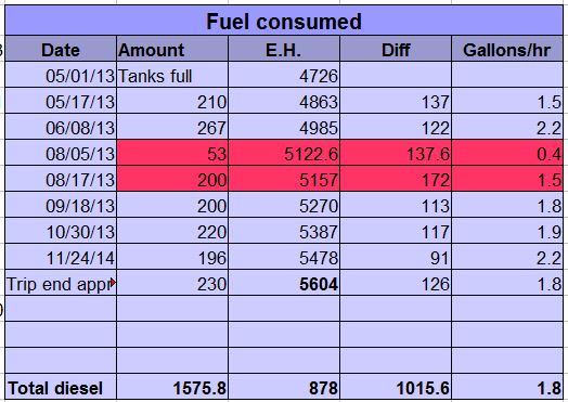
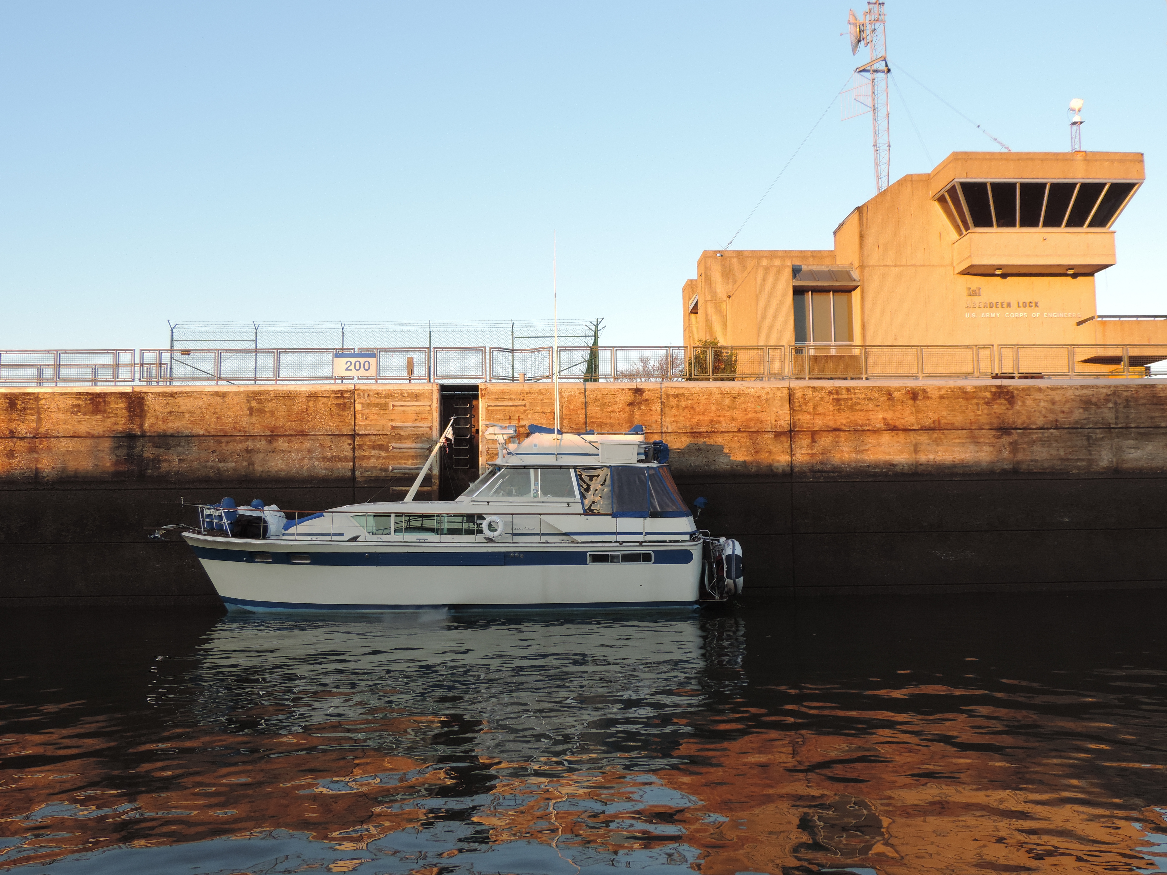
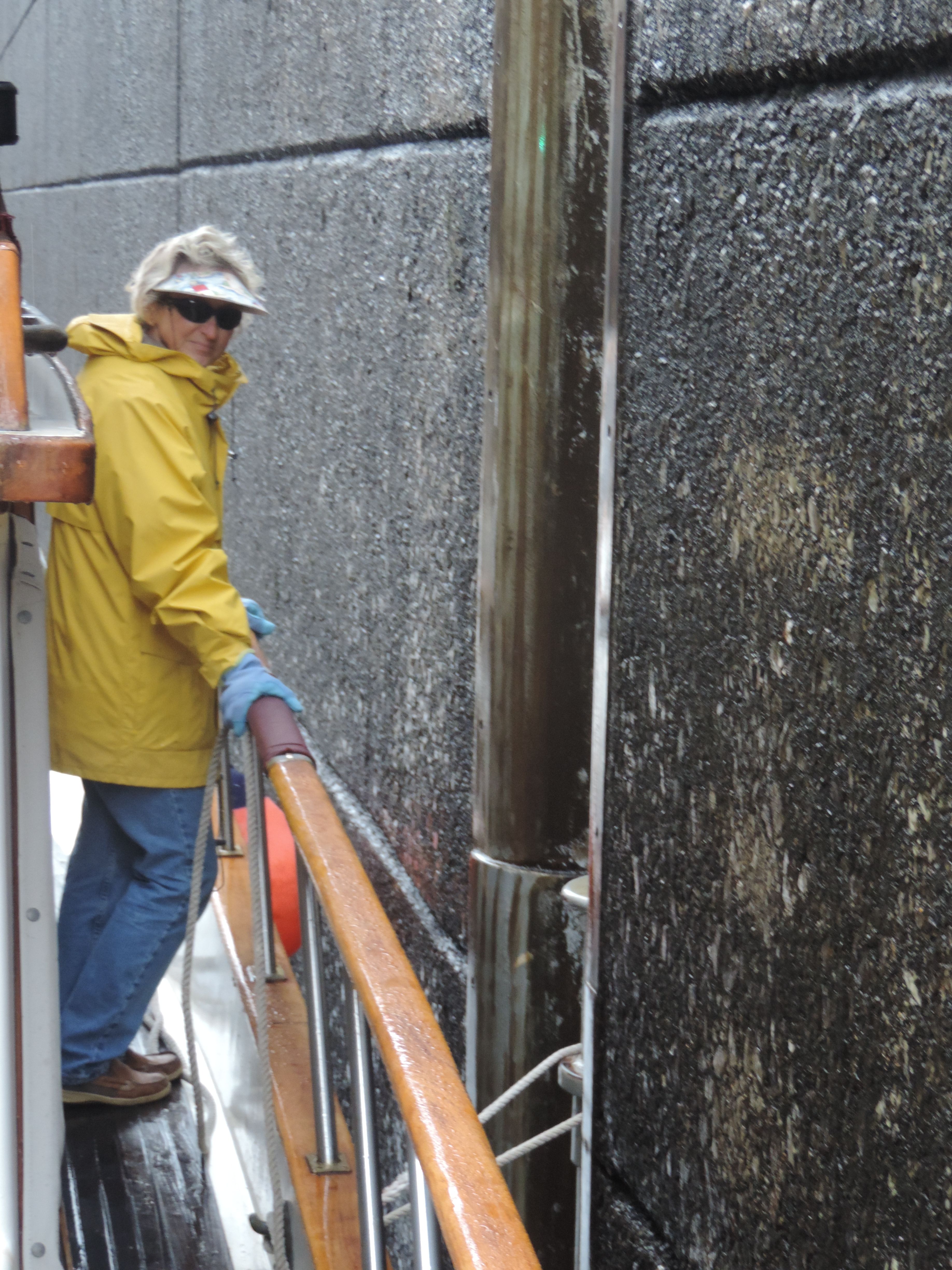
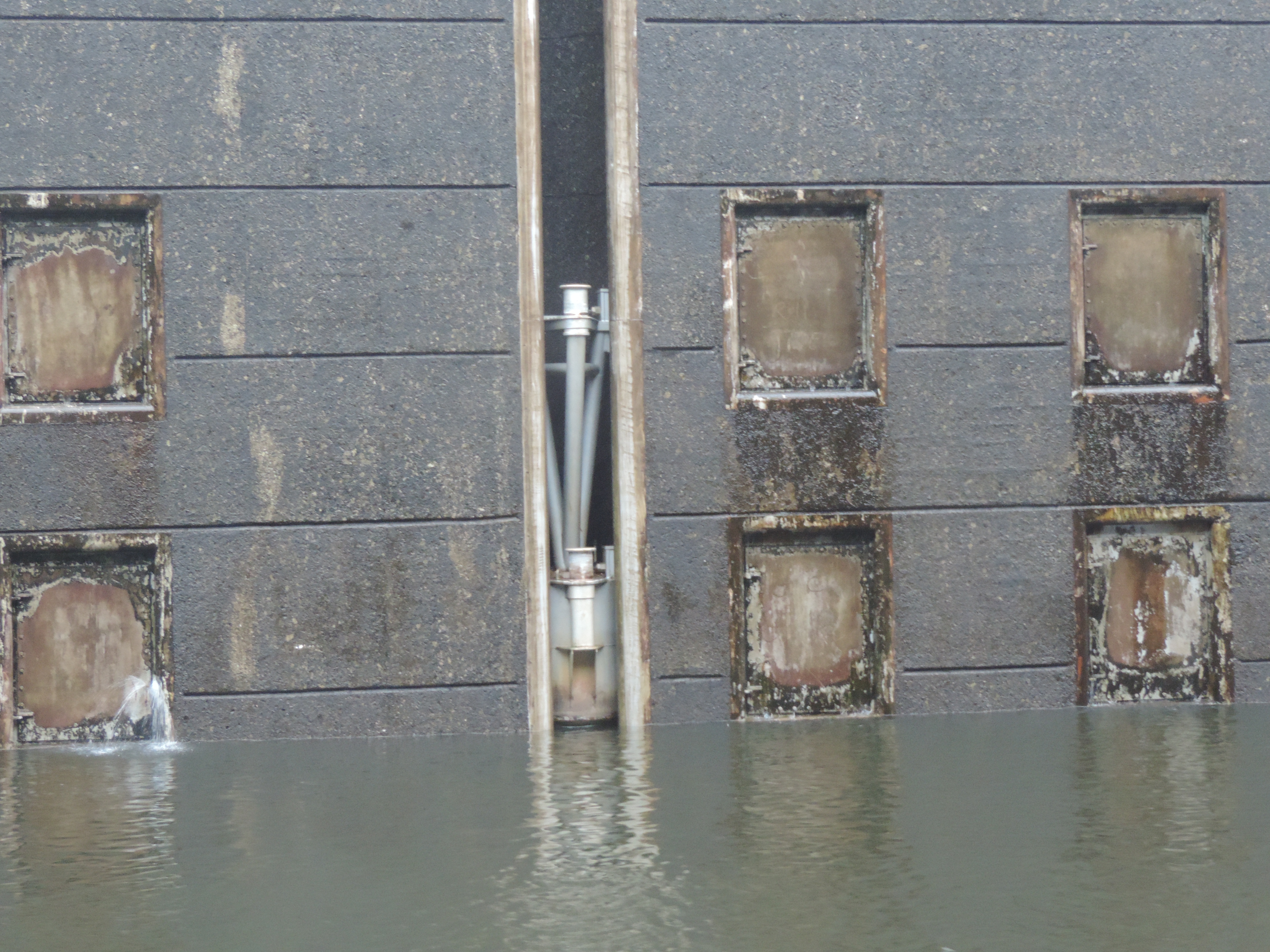
Tuesday, June 30, we were underway at 0615 in order to arrive at South Mills Lock of the Dismal Swamp Canal in time for their 0830 lock thru (the first of four of the day). About the time we reached the narrow part of the river we were hailed by another boat also heading to the lock; we arrived in plenty of time and had to “tread water” for over half an hour before we the lock doors opened and we were able to lock through, clear the bridge (which is raised after the lock is raised), and proceeded into the canal. The canal runs for about 21 miles from South Mills to Deep Creek, with a bridge and lock at each end. The only openings each day (during the season) are at 0830, 1130, 1330 and 1330 – if you don’t make one of those openings you stay in the canal at the visitor’s center, Elizabeth’s Dock (at Deep Creek), or just drop a couple of anchors. The boat that had come up behind us exited South Mills Lock before us (they were going to travel slightly faster) so arrived at Deep Creek about 10 minutes before us at 1215 and tied to the “shopping dock” near a grocery store. They invited us to raft with them, which we did, and then went shopping for a few items while we waited for the 1330 lock-through. We both locked through at 1330 and cleared the lock and were on our way to Norfolk by 1410. In Norfolk we stopped at the Ocean Marine Yacht Center for fuel. It was only the second time we had put fuel in our new tanks so were interested in seeing how well it worked; we now have four fuel fills (one for each tank) rather than the two previously. While I had anticipated that we had used anywhere from 210 to 250 gallons of fuel on the trip from Florida, we were able to squeeze only 283 gallons of fuel into the tanks, making us think that the tanks do not hold 540 gallons as stated by the tank fabricators, but more like 450 gallons – plenty of fuel no matter what the numbers. We topped off the water tanks and got rid of all of our trash, then continued northward.

After leaving Ocean Marine Yacht Center we checked the weather forecast again and discovered that high winds from the south and west were forecast for the night, so instead of going to our “usual” anchorage near Old Point Comfort which is exposed to the south and west, we opted to anchor in Willoughby Bay on the north side of the Navy base. After checking out several locations, we opted for a spot just to the north of the base marina outside of the restricted zone where we would get some protection from waves from the west and south. We anchored at 1840 to the sights and sounds of Navy helicopters practicing shipboard landings at the small air strip just to the south of us. They would fly almost directly over us as they took off from the field, then circle around, hover over a simulated ship deck, then lift and come around again. This continued well into the evening. The winds also continued well into the evening, and (Judy reports – Bob was sleeping) that around 2230 to midnight the winds had picked up to almost 60 MPH with the sky full of lightning as she stoodd anchor watch in the saloon with Sanderling cork-screwing in the wind and waves. The anchor held tight, however, and we were in approximately the same place after the storm passed and things quieted down for the rest of the night.

Today, July 1st, 2015, we were underway at 0800 to sounds of the Star Spangled Banner being played over loud speakers at the Norfolk Naval Base! Seas were just a little rough as we left Willoughby Bay, but soon settled down after we headed north about a mile off the western shore of Chesapeake Bay. At the entrance to the Rappahannock River we turned slightly to the west to head for the entrance to the Great Wicomico River where we anchored off Sandy Point at 1635 with a gentle breeze and clear skies.

Tomorrow we’ll depart early to get to Solomons, Maryland, and a buoy at Zahnizer’s Marine Center, then on to Selby Bay Marine on Friday where we have reservations for three nights so we can spend a few days with our daughter and her significant other.

Follow us on Marinetraffic.com

July 5, 2015 (Sunday)

Now at Selby Bay Marina on Selby Bay, just off the South River south of Annapolis, Maryland. We’ve traveled almost exactly 1,000 NM miles from our home marina in Florida this trip. This is very close to Jen’s house in Edgewater, so we were able to spend the weekend with her and Don after arriving at the marina on Friday, July 3rd, after departing Solomons, Maryland, at 0620 on Friday morning. The trip from Solomons was fairly smooth on Chesapeake Bay, with several other boats (sail and power) departing Solomons basically heading to Annapolis and their great 4th of July fireworks display. It was only a 48.4 NM cruise for us since we stopped about 6 NM short of Annapolis. As we approached the entrance to the South River the number of boats on the water increased substantially, with apparently many boaters out for a long weekend. Once we turned into Selby Bay things quieted down. The marina had assured us that we could fit under their covered slip (the only slip they had available), but when we saw it we approached very slowly at low tide and even then we wouldn’t fit. The young man on the dock (son of the owner/manager) had no idea how high the opening was – only that it wouldn’t be a problem. We assured him that the opening was less than our 22.5 feet in height as Judy watched from the stern as I moved forward very slowly. We backed off and the young man called his father to try to locate another slip for us – there wasn’t one. So we offered to lower our radar mast so we would fit. We pulled up to the fuel dock and the owner and his son came aboard to help us lower the mast by hand (normally we use a gin pole and a six part rope fall). The mast was down in short order and we were in the slip with plenty of room above our 15.5 feet at the bimini top! Next came trying to figure out the electricity, which also seemed to be a mystery to the young man working the dock as well as his father – but that eventually got resolved, also. We met up with Jen and Don for dinner at a great German restaurant nearby, then had a quick tour of their neighborhood and their house – a nice little bungalow about 1 block from the Bay.

The trip from Sandy Point to Solomons on Thursday started quietly at 0630, but by the time we had crossed the mouth of the Potomac River and had Point No Point Light to port the weather turned on us. The wind shifted to the north at 20 to 25 knots and the temperature dropped about 10 degrees. With the wind from the  north and an opposing current, the waves picked up and it was a rough ride for two hours before we rounded Cedar Point and headed up the Patuxent River to Solomons and a quiet mooring ball at Zahnizer’s Yacht center. We prepared the dinghy for use (we hadn’t used it yet on this cruise) and went ashore to eat at one of our favorite restaurants in the area, C&D Cafe! Fortunately we got there early enough that it wasn’t too crowded and we were able to get one of the last tables for two.

Our 4th of July started with Bob spending about 5 hours in the engine room changing out the heat exchanger and two oil coolers (the two coolers arrived at Jen’s earlier in the week). Bob also replaced the electric horns (one of which had stopped working) and put in a new “approved” propane pigtail (all ordered from Defender earlier in the week and shipped to Jen’s). We also have a new rebuild kit for our two heads! The joys of cruising. Judy spent the day working on some of her cases. Later in the afternoon (Bob didn’t even get a nap), we met Jen and Don for hamburgers and hot dogs at their house, then walked around their neighborhood, returned for ice cream and walked to the beach to watch some fireworks across the Rhode River from their beach. By the time we got back to the boat we were both exhausted, went to bed and didn’t wake up until after 0800 this morning.

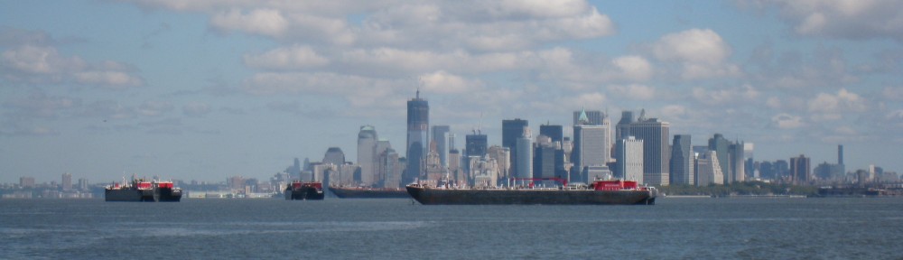
Tomorrow we’ll try to get out of here by 0630 heading north up the Bay. Bob has rigged our rope fall and gin pole so we can raise the mast by ourselves once we clear the slip. We’ll stop at Veasey Cove, Chesapeake City, or Reedy Island (Delaware Bay) depending on how the tidal currents treat us. After that we’ll stop at Cape May, New Jersey, then Atlantic City, and then the big run to Great Kills, Staten Island. From there it’s through New York City and the East River to Long Island Sound, east on the Sound to Rhode Island and Massachusetts. May not have a chance to update the blog between here and there (not sure where “there” might be), but you can follow us on Marinetraffic.com, if you wish.

July 13, 2015 (Monday)
Trying this for first time. Came into Great Kills Harbor yesterday and took a mooring from Richmond County Yacht Club for the night. Judy had a package waiting for her at a nearby UPS store which she picked up at 0800 this morning. Now we’re waiting for the tide to change to flood on the East River in NYC so we won’t have to battle the current (and go backwards) at Hells Gate.

Trip up the NJ coast on Saturday was fairly calm. Saw two whales (we believe to be humpbacks) at different times during the 13.5 hour cruise. Anchored for the night at Sandy Hook, NJ then came the 8 miles to Staten Island on Sunday morning. Had a little excitement involving watching the CG at Sandy Hook respond to an injury aboard a vessel before we got underway.

In less than an hour we get underway for NY harbor, the East River and into Long Island Sound.

More later.

July 14, ,2015 Tuesday
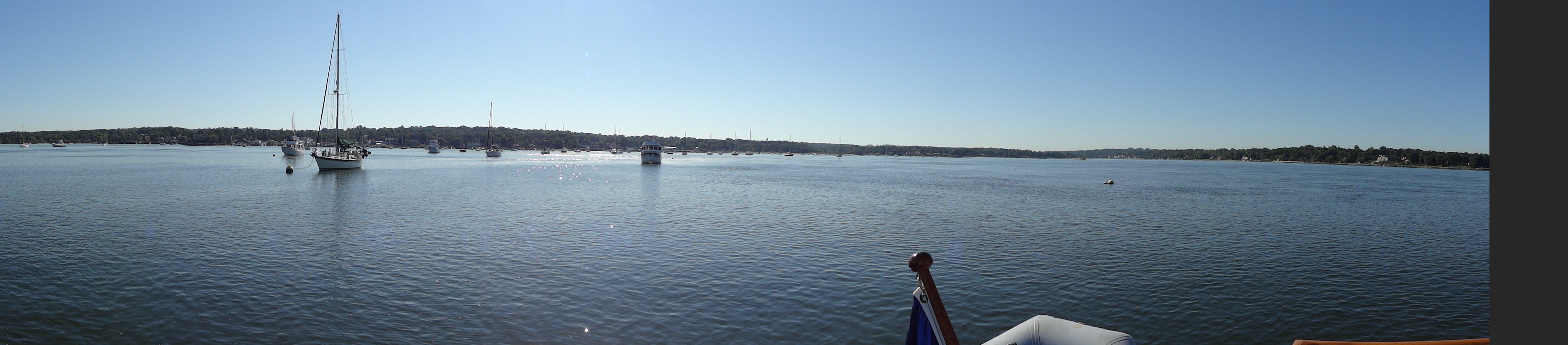
My calculations for the best time to transit the East River didn’t work out and we had a slight current against us until about the time we reached Hell Gate and then the slack tide finally caught up with us. We continued into Long Island Sound and then into Manhasset Bay where we took a free town dock mooring ball for the night.

Today we were underway at 0850 and had our lines to a mooring ball in Port Jefferson at 1410 after 36.5 NM and 5H30M. Tonight we took the launch ashore for dinner at a great little restaurant (Zpita) where we ate during a major rain shower which stopped just in time for the conclusion of our meal and a walk back to the launch dock via a great ice cream store!

Tomorrow (Wednesday) we head for Montauk where we’ll anchor in the pond, possibly for two nights waiting for winds on Thursday to calm down enough to get to Martha’s Vineyard.

July 25th, 2015 (Saturday)

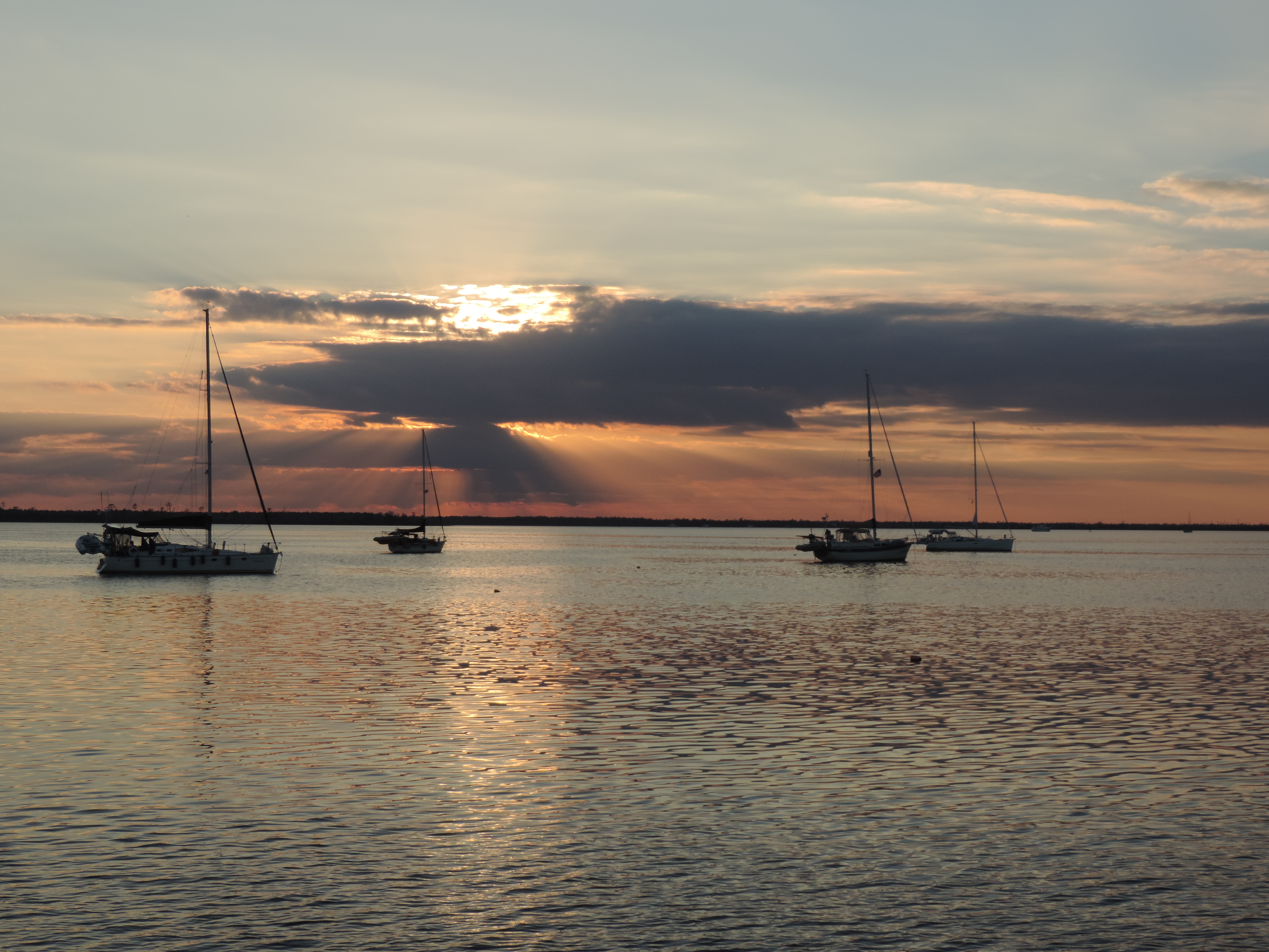
We stayed in quiet Montauk Pond for two nights while winds subsided on Block Island Sound on the 16th. The night of the 16th we ate in the very upscale (ritzy) Montauk Pond Yacht Club and Marina with reservations at 1800 (thank you very much). The Adarondak lawn chairs were perfectly lined up along the manicured lawn so anyone who wished could sit and watch the sun set over the “pond.” We dinghied to the club from our boat anchored about a mile north of the club. Great meal and nice evening!

We were underway in Montauk Pond at 0630 on the 17th (Friday) and headed out into a fairly calm Block Island Sound, past Block Island and Narragansett Bay (and Newport) and into Buzzards Bay. We originally had planned to go to Martha’s Vineyard, but the weather forecast for later in the weekend caused us to opt instead to go into Buzzards Bay instead in order to avoid further delays in getting to Maine. We tried to anchor in Clark’s Cove about 1645 but could not get the anchor to grab despite repeated attempts, so went back to the west around a short peninsula into Apponagansett Bay and took a mooring at the New Bedford Yacht Club at 1745. After the tender showed us the mooring, we discovered that since we were leaving the next morning and weren’t going to use the tender service nor go ashore, we would not be charged for the use of the mooring for the night! It was a good, quiet night on a mooring.

Saturday morning we case off from the mooring at 0635 in order to catch a fair tide all the way up Buzzards Bay and through the Cape Cod Canal. The wind picked up slightly throughout the morning, and by the time we transited Cape Cod Canal (where our speed over the ground topped out at 10.5 knots with the current) and entered Cape Cod Bay it had picked up a bit more. When we turned slightly westward to follow the shoreline leading to Plymouth, Massachusetts, it picked up considerably and the waves were approaching 2-3 feet with gusts to 20. We made it through the channel into Plymouth and contacted the Plymouth Yacht Club for directions to the mooring (which we had reserved), and after a great deal of difficulty picked up the mooring only to realize that we were much too big for the mooring and the surrounding space; the yacht club staff in the tenders agreed and we moved to another mooring with much more room. Judy and the tender driver working together were able to snare one mooring pendant, and then we secured both mooring pendants (two to a ball to make a yoke) with extra line and felt we would be OK for the night. We were secure on the mooring at 1330. The wind continued blowing at 20 knots with higher gusts, so we bounced around a bit. We went ashore later in the afternoon when the wind started to die down a bit we took the tender ashore, confirmed that we would be able to stay a second night night if the winds didn’t improve, and ate at a great little sub shop not far from the marina after walking around town a bit (saw the remnants of Plymouth Rock, looked at the Mayflower replica from a distance, dodged traffic), and then had some great ice cream for desert!

The wind had died down completely by late in the evening and everything looked good to transit Cape Cod Bay and Massachusetts Bay on Sunday. We dropped the mooring at 0640, July 19th (Sunday) heading to Rockport, Maine, at the eastern end of Cape Anne. After about three hours we changed course for Gloucester, Massachusetts, in order to get fuel (we had heard that prices for diesel there were low). We stopped at a fuel dock in Gloucester at 1305, took on 235 gallons of diesel (not at a low price), and departed the fuel dock headeing to Rockport at 1400. We had reserved a mooring at Rockport earlier that day, so when we arrived at Rockport we called the harbormasters office to ask for the location of our mooring. Scott and Rose identified themselves as being on a boat in the harbor and asked if we’d ever taken a fore and aft mooring before; when we let the know that we had not, Scott said he’d come aboard to help us – and before we knew it they were alongside and Scott hopped aboard. This turned out to be the secret to cramming so many boats into such a small space with current from a 9 foot tide – all the bigger boats in the harbor (actually on the south side of the fairway) are tied to moorings at the bow and stern. Scott first talked to me to tell me what we were going to do, then he went forward and talked with Judy. He directed me to a pickup float at the far end of the harbor, he and Judy reached down and picked up the float and hauled it aboard. It was attached to a small stuff line which was in turn fastened to a mooring pendant which would be attached to the bow and a second mooring pendant which would be attached to the stern; both pendants were attached to different locations on the bottom of the harbor and both “ends” had two pendants to form a yoke. By the the time we were through Judy had secured two pendants to the bow, Scott had jumped back on the harbormaster’s boat with Rose driving, reached under the water with a boat hook and grabbed a ring containing the second stern pendant, attached one of our spare lines to the second pendant and had us pull it aboard and cleated at the starboard side of the transom. We were fast in the harbor, fore and aft, facing the harbor entrance, and would not swing with the shifting tidal current or the wind. Other boats were similarly moored no more than 15 feet away. Quite a setup! We ate dinner aboad, then took the dinghy ashore and had ice cream for desert. We like Rockport so much that we stayed a second night in order to walk around the town. The second day we ate a lobster roll for lunch, had a nice dinner ashore with ice cream for desert AND walked around the waterfront area during the day. Rockport, Massachusetts, is still one of our favorite New England towns!

From Rockport we were underway on Tuesday, July 21st, at 0845, and headed to the Navy marina at Sound Basin, Kittery, Maine (across from Portsmouth, NH) with a great view of the old Navy prison where Bob was stationed for a year in 1966-67. We had fog all the way from Rockport to Kittery, and could only see other boats and land via radar, most of the time. We stayed a second day so Judy could get blood drawn at the small clinic there for her doctor in Florida. We also did some shopping at the commissary. Nice place to stay and we had two quiet nights on a mooring (after a storm passed through late on the second afternoon).

We departed Kittery, Maine, a 0630 on Thursday, July 23rd, heading to Portland, Maine. We saw at least one whale southbound about half way and think it might have been a minke whale – rather small – definitely not a humpback or northern right whale. We had lines to the slip at the South Port Marina at 1410 that afternoon. Dinner at our friends Norm’s and Nancy’s house that evening, grocery shopping and a trip to West Marine for a new yacht ensign and VHF radio then dinner out with Norm and Nancy on Friday. Tonight we went with them and other neighbors to a concert at the Cape Elizabeth Lighthouse by the Portland Symphony Orchestra – great evening, great company, great food prepared by Norm and Nancy.

Tomorrow we meet Norm and Nancy for brunch, then we’re heading to South Freeport for at least one night and some of the best lobster rolls in Maine!!!

More later!

Friday, August 7, 2015

WOW! I didn’t realize it had been almost two weeks since I updated this blog. You can’t believe how much effort it takes to keep it relatively up to date when you’re cruising. Tired after a day underway, things to do, meals to prepare and cook, shopping to do, places to visit, no internet access, – to name a few things that get in the way.

We’re now on a mooring at the Wooden Boat School on Eggemggin Reach near Brooklyn, Maine. Arrived here about noon today after departing Pulpit Harbor (across the bay from Camden, Maine) earlier in the morning and having an absolutely spectacular New England (Maine?) day on the water for three hours between points. We went ashore and visited the grounds of the Wooden Boat School. Bob took two 2-week courses here in 1988 and 1990 – place actually hasn’t changed much, except it seems a lot busier. Rich (the current Director who was the shop foreman when Bob was a student) said they had nine courses going on this week, including a women’s sailing course and a week-long cruising course in addition to all the boat-building courses. What a great place!

I’ll try to bring everything up to date later this afternoon (after my nap).

Nap and dinner are over with. Now for a big update!

Thursday, July 23rd, 2015 – Portsmouth, New Hampshire (actually, Kittery, Maine)
After a stormy afternoon on Wednesday and shopping at a small base commissary on Wednesday, we dropped the line to the mooring at the Navy marina at 0630 and headed out the Piscataqua River, then north to Portland, Maine. The ocean was fairly calm and we made a course straight from the sea buoy at Portsmouth to the light at Cape Elizabeth. Seven hours and 40 minutes and 49.8 NM miles later we were in a slip at South Port Marina in Portland, Maine. About half way we saw a whale (probably a finback) heading south; this was one of about six whales we’ve seen on the trip, the first off the coast of New Jersey. We had dinner with friends Norm and Nancy at their beautiful summer home on Cape Elizabeth, then went back to the boat for a quiet night’s sleep knowing we didn’t have to get up early the next morning to get underway.

While in Portland we spent every evening with Norm and Nancy. Dinner at a nearby restaurant on the second night, and on the third night we, along with a group of neighbors, attended a 250th celebration at the Portland Head Light at Cape Elizabeth for a picnic and a pops/light classical concert by the Portland Symphony Orchestra. By the end of the evening everyone was huddled under blankets, even the Mainiacs! We also did some boat shopping with Norm (had to buy a new yacht ensign since the old one had torn and a new VHF radio to replace the inside radio that had decided it wouldn’t receive any of the Coast Guard channels), and some major grocery shopping at Hannafords.

We also met a couple in the marina where we stayed who had recently purchased a DeFever 41 (same as ours) built a year later than ours in the same boat yard. The boats were almost identical in outward appearance, and both Bob and Judy were able to answer many of their questions about how things worked and where various systems were located.

Sunday, July 26, 2015 – Portland, Maine
We had brunch with Norm and Nancy and a visiting friend, then got underway at 1325 after taking out the trash and filling the water tanks. We had a short 13.8NM and 2H05M day going to a mooring at Strauds Point Sharf at South Freeport, Maine, basically north of Portland. We stayed a second day and took a taxi to Freeport, Maine, home of L.L. Bean, as well as many outlet stores from all of the major retailers. We bought a few things at Beans, and Judy found some new boat shoes at one of the other stores. Dinner consisted of more lobster rolls at a lobster shack at South Freeport; we concluded later that we’ve already had our fill of lobster rolls after two dinners – we think lobster is good in some things, but neither of us consider it a delacacy.

Tuesday, July 28, 2015 – South Freeport
We cast off the mooring line at 1010 with fog rolling into the small harbor. By the time we cleared the harbor we were in a heavy fog navigating by AIS and radar, listening for fog horns and the sounds of nearby boats. The fog would clear slightly, then come back in. Most of the three hour trip to Snows Island was in fog through heavy concentrations of lobster pot foats; in several places the floats and the fog were so thick we had to rely on our radar to identify floats in front of us in time to avoid them as we headed up Qauhog Bay with less than 1/16th mile visibility! However, by the time we neared Snows Island the fog lifted and the sun came out to reveal the beautiful anchorage that we remembered from past years. We had the anchor down northeast of Snow Island at 1310 after traveling 3H00M and 18.9NM.

While at this anchorage I had time to catch up with a few things, although there was no internet access. One of the things I was able to bring up-to-date was our electronic log which contains all the data about time, distance, and location in a spreadsheet that displays time underway, statute and nautical miles, etc – all the essential data about our cruise. Here are the cruising stats to date for our cruise:

Total hours underway: 265H30M
Total miles: 1635 nautical miles; 1899 statute miles

On Wednesday, I changed the engine oil and oil filer! We also took a dinghy tour around the island and just enjoyed the quiet, beautiful scenery.

On Thursday, July 30th, we were underway at 0640 in calm, partly cloudy weather. We made good time around the headlands to the east of Quahog Bay and then set course to the northeast into Boothbay Harbor where we took a mooring at Browns Whart, across the harbor from the main town area. About half way we saw seals sunning on the rocks at Fuller Rock – not an uncommon sight but something that we don’t see very often because they like the sun (not fog) and the rocks need to be exposed at high tide – a combination that doesn’t occurr very often when we happen to be in the area.

We took the trolley to the main part of Boothbay and walked the streets with the rest of the tourists. Not much of interest there, but we did find a beautiful painting by a local artist that will go well with another painting from Rockport, Massachusetts, that we have at home (we bough the painting thinking it would look good on Sanderling, but when we got it back to the boat we decided that it was too nice to keep on the boat). We also walked around the harbor to the Boothbay Harbor Shipyard where the Bounty was restored a few years before her ill-fated voyage into the eye of a hurricane! Now they’ve just started work on another wooden ship, the Ernestina-Morrissey (check for the details using Google). It will be a $6 million dollar, 7 year project for the restoration of this beautiful schooner owned by the state of Maine used as a sail training classroom!

On the second day we took our dinghy across the bay and tied up at a dinghy dock in the middle of town. Just after we’d had lunch, we just happened to see a lobster boat in the downtown area with several passengers (obviously not lobstermen) and a sign indicating that the boat was a working lobster boat that gave demonstrations of lobstering. We followed the boat to it’s dock and inquired about the next “class” – it was going to take place in another half-hour where we’d go out with the two lobstermen who would raise six pots with their lobsters and explain what they were doing. We were on the next trip! What a great afternoon with the men. They were extremely informative, answered questions, explained everything they were doing, and obviously enjoyed helping us learn their trade. It is something we’ll never forget, and their explanations helped us understand what we were seeing every day we are on the water up here in “lobster country.” Earlier that day we had called for the free pump out boat to come alongside and pump out our holding tanks. Since so much of the area here is a “no discharge” zone (meaning you cannot pump even treated sewage overboard) many of the towns and harbors offer this free service in order to encourage boaters NOT to dump sewage overboard – a great idea!

Saturday, August 1st we were underway at 0825. We would have loved to stay another day or two in this lovely area, but new areas beakoned! We entered the Damarascotta River a short distance from Boothbay Harbor timed to get the mid-flood tidal current on the river and a gentle push through “The Gut” which was a narrow part of the river where the normal ebb and flow of the tide creates extremely fast currents. Turns out we received a 4 knot “push” through The Gut before turning 180 degrees o enter Seal Cove, an anchorage we had read about in our cruising guides reputed to be one of the most beautiful in Maine with its own family of seals. Sure enough, the area was beautiful, we timed the tide well and had plenty of water over a shallow area leading into the anchorage, and the seals entertained us most of the afternoon after we anchored at 1000 after 1H35M and 10.8NM underway.

On Sunday, August 2nd we were underway at 1120 and at 1405 we had taking a mooring at Round Pond after 17.1NM and 2H45M. This was a mid-day change from our original plan of going to Hog Island and the Audobon Preserve we had visited in 2006. We’d never been to Round Pond (more or less on the way to the Audubon Preserve) so we decided to see something new. We’re glad we did. Round Pond is a delightful small working harbor with just a few mooring balls that are rented out by the local boat yard. As we were looking for an available mooring the boat yard owner and his family showed up in a small center consel boat and to help, and a boat on one of the rental moorings told us that they were leaving and that we could take their mooring which had plenty of swinging room. Interestingly, the boat that left the mooring had spent the afternoon with us in Seal Cove the day before (one of a few boats that came to Seal Cove for a few hours to watch the seals). We dinghied ashore for dinner in a restaurant, followed by . . . ice cream!

The next day, Sunday, August 3rd, we were underway at 0655 heading to Camden. We entered Penobscot Bay at 0825 and soon encountered heavier swells, lots of lobster floats, and FOG! One or two of the three alone isn’t bad, but with the fog, floats, and then heavy swells it makes for a tiring day having to hand-steer (rather than rely on the auto-pilot) all the time to deal with the swells and the pots. We could hear fog hors, see boats and ATONS on radar, and some other boats on AIS. We could also hear boats talking with each other arranging passage in the fog. Everything demands our undevided attention and it’s very tiring. AIS helps tremendously as we’re able to identify the larger vessels (and they us) and talk with them by name to arrange a safe passage. We were glad when the fog started to lift as we approached Camden Harbor and were directed to our mooring for the next two days.

Camden is an interesting town with lots of shops, restaurants, and boats. The thing that boaters do not see, however, is the harbor. It’s a large harbor filled with mooring balls, almost all of which are occupied. Some of the moorings are privately owned, some owned by the yacht club or by the one marina. The harbor faces south-southeast, but even a southerly wind combined with the tidal current seems to constantly stir up the water in the harbor making a very rough ride at the moorings. We only had a few hours of calm each day before the wind and tidal current set the washing machine in motion, again.

We walked the streets, did a little food shopping at a very small food store, and took real showers at the marina! We also filled our water tanks before leaving so we would have an adequate supply to get us to our next marina where we could get water. We had hoped to climb Mount Battie (lies just outside Camden) the second day we were there, but we woke up to fog and rain which continued into mid-morning, so had to forego our second ascent (the first was in 2006)!

We were happy to depart the rockin’ rollin’ harbor of Camden for smoother harbors on Wednesday, August 5th. Before departing the harbor we went to the marina’s fuel dock for water and trash disposal, then headed to Southern Harbor, which is on North Haven Island, just across Penobscot Bay from Camden. It’s a nice, quiet spot and we were the only boat anchored there. The next day we went to Pulpit Harbor on the same island (just about 2 miles directly across the island from Southern Harbor but 12 miles by boat). Pulpit Harbor is a place where every boat on Penobscot Bay stops – it’s crowded, quiet, and anchorage room is limited, and holding is rather poor, but the sunsets (if there is a sunset) are spectacular and it’s well protected from winds. We stopped there for a night in 2008; we probably won’t stop there again!

We departed Pulpit Harbor this morning at 0850 and arrived at the Wooden Boat School at 1220 after 23 NM. The water was spectacularly beautiful with very little wind all the way through Eggemogin Reach to the Wooden Boat School which sits on the northern shore of the reach toward the eastern end. Eggemogin Reach is renouned for it’s great sailing, since it is one of the few places in Maine where sail boats can sail beam reaches (the wind on the beam) with the prevailing south-westerly summer wind for about 10 miles, then turn and have a beautiful beam reach back up/down the reach. We arrived to find an available guest mooring on the outer perimeter of their mooring field filled with beautiful wooden boats, most built at the school by their week and two-week boat building classes. We toured the grounds, talked with the director, and headed back to Sanderling for a peaceful afternoon in the warmish Maine sun.

The next three days will put us about 22 NM east of our current position. We’re going to depart WBS tomorrow and go a few miles to Buckle Cove and then Mackaral Harbor before going to Northeast Harbor on Mount Desert Island for a few days.

Weather is forecast to be great for the next week or so – hope the forecasters are accurate as we still have a lot of Maine to see before heading south toward the end of the month.

Wednesday, August 12, 2015 – Sommes Sound Harbor, Maine

A quick update while we have decent internet.

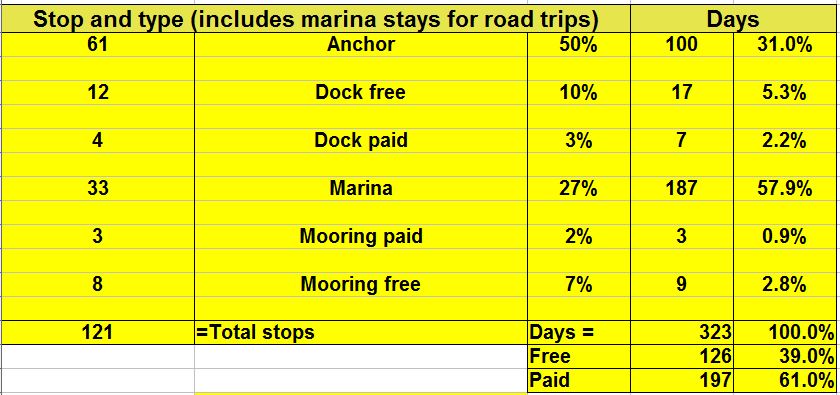
One thing I may not have mentioned earlier is the matter of the distance and time that we’ve cruised that I try to remember to note in the blog. Distance is determined on a daily basis, taken from our two chartplotters which (we hope) we reset every day when we’ve finished cruising that day and are anchored, at a mooring or at a dock/marina. We work with nautical miles now that we’re out of the Atlantic Intercoastal Waterway (ICW), but while we’re in the ICW we use statute miles since the ICW is measured in statute miles rather than nautical miles. Time underway is based on our own observation of the time when we let loose a mooring, raise the anchor, or cast the lines off a dock if in a marina, and again when we anchor for the day, take a mooring, or go into a slip or dock at a marina; the difference is our underway time. The engine is actually running before we get underway by at least 5 minutes or so when starting for the day (longer if we know we’re immediately going to have to get up to full speed, such as in a river with a current) and may run 5-10 minutes after we are no longer underway (when we stop for the day) while we shut off various systems and throttle back to engine rpms to let it cool down before turning it off. Both the distance and the time underway are noted in our ship’s log at the end of each day’s run, then entered in a spreadsheet which calculates total time and total distance, both nautical and statute miles, as well as some averages I like to keep track of and the number and percentage of times we anchored, paid for a mooring ball (or got one free), or paid for a marina or got a free dock.

We departed Wooden Boat School on Sunday, August 9th, 2015, after spending two nights there. We had beautiful sunsets each evening, the weather was perfect with sunny days and quiet nights, but we had to move on. We had intended to go into Buckle Harbor on Swans Island just to see what it was like and then go a short distance further and anchor in Mackeral Cove, but when we got into Buckle Harbor we thought it was so nice and peaceful that we decided to anchor there for the rest of the day and that night. We weren’t disappointed. Two sailboats came in during the day, but the harbor is so large that they anchored some distance away and we hardly noticed that we had company.

Day: 6.1NM   –   1H00M
Trip: 1798.2NM/2066.3SM   –   288H05M

The next day, Monday, August 10th, we were underway (anchor up) at 0930 and at 1145 had our lines to a floating dock in Northeast Harbor on Mt. Desert Island. We had fog most of the way, and as always here, lots of lobster pot floats!

Day: 14.0NM   –   2H15M
Trip: 1812.2NM/2082.4SM   –   290H20M

As we were coming into the harbor friends Glen and Jill on Last Dance hailed us on the VHF radio to let us know that the other side of the floating dock they were on was free, so we had a nice get together with friends whom we see from time to time when we cruise. After going ashore and paying for the mooring, the four of us took their dinghy to another floating dock across the harbor and climbed the 200 steps and the paths to Thuya Gardens which overlooks the harbor and still has many flowers in bloom. After we descended the steps we walked about a mile along the road to an Asticou Azalea Garden created in the Japanese style – both beautiful places to visit; unfortunately, we missed the azalea season by several months! On Tuesday Glen and Jill departed for Sommes Sound, then Judy and I took the free bus into Bar Harbor where we had arranged to get our hair cut at one of the salons, ate breakfast at a little sidewalk cafe next to the salon, and replenished our food supplies at a Hannaford market just down the street. After completing our grocery shopping we schlepted our bags back to the bus stop, took a launch from the harbormaster’s office to Sanderling, and got our groceries aboard just as the rain started to get heavier! Later in the day the rain and wind intensified and we had quite a storm before everything stopped around 2300 in the evening. Our weather station clocked winds as high as 28 knots and we had about 1″ of rain during the day. Between the wind and the rain (and being on a stationary dock so we didn’t cock into the wind) we found a few wind-driven leaks around doors that need to be addressed when we get back to Florida.

Today, Wednesday, August 12th, we filled the water tanks and cast off from the dock at 1035 after waiting as long as we could for the fog to lift. It kept coming and going, so finally we just worked our way out of the harbor using the chartplotters, radar, and AIS (and a sharp lookout) and westerly around the southern end of the island into Sommes Sound (a fiord), up the sound to Sommes Harbor (a small community) and took a mooring at 1145. By the time we got to the harbor the fog had lifted but the sky was still overcast and didn’t clear until later in the afternoon when the sun finally peaked through.

Day: 6.5NM   –   1H10M
Trip: 1818.7NM/2089.8SM   –   291H30M

We’re going to stay here another day and take the free bus to Southwest Harbor just to see the area and check out Hamilton Marine and West Marine in case they have something we need for the boat. Perhaps we’ll luck out and find ice cream!

Weather for the next week looks good, with relatively gentle waves on the ocean to the east, we we are planning to depart this nice spot on Friday and head about 40NM to the east to the Roque Island area, stay a day or two there, then return to Northeast Harbor for a night. At that point we’ll start to work our way west back to Casco Bay where we’ve reserved a mooring at South Freeport starting on the 25th of August for 10 days. More about that later!

Saturday, August 15, 2015

One thing about boating, plans are always subject to change – as we have so many times. Rather than heading further east,from Somes Harbor, we decided to start a slow trip back to the west. For one thing, we’ve already “been there; done that” back in 2008, and for another we were concerned that we’d get further east along the ocean and then have the weather change to something less comfortable which would result in delaying our return to South Freeport. So, our plan changed the last night in Somes Harbor.

On Friday, August 14th we were underway from the mooring at 0815, stopped at Able Yacht Yard at 0830 to pump out our two holding tanks, and were again on our way at 0905. We transited Somes Sound and then southward past the Cranberries, then hung a right and headed east to Mackeral Cove. We had the anchor down at 1145.

Day: 18.3NM   –   2H55M                   Trip:

We plan to stay here through tonight (the 15th) and later tomorrow (Sunday) check on the availability of a mooring (first come, first served) at Frenchboro (Long Island) and the Thorofare (Isle au Haut) and stop at the first location with an available mooring. If not either of those, then we’ll move on to Seal Harbor on Vinylhaven where we’ll spend a couple of days. After that: Hog Island, Goothbay, the Basin (Casco Bay), and then on the 25th to South Freeport. Sounds like a plan – subject to change!

Monday, August 31, 2015 – South Freeport, Maine

Just looked at the blog and realize we’re half a month behind. I’ll do my best to get you up to date now.

We had a nice two-day stay at Mackerel Cove on the west side of Roderick Head. It was quiet, good holding, the weather was sunny, and only a few other boats came into the area to anchor while we were there. We departed on Sunday, August 16 at 1015 and by 1135 we’d traveled 8 NM and taken a mooring at Lunts Harbor, Long Island, Frenchboro.

Day: 8.0NM   –  1H20M
Trip: 1845.0NM/2120.1SM   –   294H25M

What a delightful visit we had in Frenchboro. It’s a small island owned by the state of Maine as a conservation preserve. There are only a few houses scattered around it’s small harbor with fewer than 20 families living there year around. It’s great claim to fame for cruisers is Lunt’s Dockside Deli serving up relatively inexpensive lobster dishes such as steamed lobsters (of course), lobster mac and cheese and lobster grilled cheese sandwiches! We had lunch (the mac and cheese and the grilled cheese) then walked the road which winds around the harbor, stopped at the museum/gift shop, and then headed
back to Lunt’s Deli. We arranged to pick up a home made pizza for dinner (“should I just run a tab?” – “sure”) and I watched the lady make a fresh ice cream sandwich with two home made chocolate chip cookies and two scoops of home made vanilla ice cream that I needed before we headed back to Sanderling on the mooring. Earlier, while walking around the harbor, we noticed a boat that looked familiar take a mooring, and we both commented that it looked like Bruce and Joan Kessler’s Spirit of Zopilate – a beautiful one-off boat that is hard to miss. We didn’t think much more about it, but as I was sitting at Lunt’s eating my ice cream sandwich we watched a dinghy leave that boat with four people aboard; as they drew closer and tied up at the dinghy dock we readily identified Bruce and Joan (we’ve met them a number of times over the years and shared steamed crabs with them at a table at several early Trawler Fests). The other couple came up the ramp from the dock to Lunt’s and the guy was wearing wrap-around sun glasses which mostly hid his face. When Bruce and Joan came up the ramp I wiped as much ice cream from my face as I could and stood up and identified myself to Bruce; the guy with the wrap-arounds exclaimed “Bob McLeran, I thought that was your DeFever on the mooring next to us!” Turned out to be Georgs, the owner benefactor of the Trawler-and-Trawlering Lists whom I’ve worked with since the late 1990s. The last time we saw Georgs was in 2011 at Jones Falls in Canada when he brought us a Canadian Care Package with beer, wine and cheese!

We had a great rendevous on the dock!

We departed Lunt’s Harbor in heavy fog at 0920, Monday, August 17, 2015, and threaded our way around Marshall Island and Isle Au Haute (where the fog eventually lifted to allow us to see the islands, through Merchant’s Row, and entered Seal Bay on Vinalhaven island. This is a spectacularly beautiful bay that reminded us of some of the areas we visited in Georgian Bay, Ontario, Canada. We continued around the granite and tree-covered islands within the bay to the south side of Penobscot Island where we anchored with only a few sailboats in sight.

Day: 23.0NM   –   3H40M
Trip: 1868.0NM/2146.5SM   –   299H25M

During the day a sailboat came into the area where we were anchored, tossed an anchor over the bow and let out some chain, never backed down to ensure that their anchor had “grabbed” the bottom, and went below never to emerge again! At night, but boat didn’t show an anchor light! This isn’t the first time we’ve observed sailboaters being so casual about anchoring – must be something in their genes!

We reluctantly departed Seal Bay the next day (Tuesday, August 18, 2015) as the weather forecast was good and we had to cross the wide open southern (ocean) end of Penobscot Bay to get to our next anchorage at Hog Island. We had the anchor up and were underway at 0640 in clear air; almost as soon as we left Seal Bay we encountered fog which continued until 0930 when we were in the middle of Penobscot Bay. When we approached the recommended shipping lane in Penobscot Bay we issued a “securite” on the VHF radio to let other boats know our location, course and speed since visibility was less than 1/4 mile. We could track other boats on our radar and AIS, but other boats don’t necessarily have those tools available, however, most boats have a working VHF radio onboard. After the fog lifted we had a nice cruise past Port Clyde and into Muscongus Bay.

We arrived at the northern end of Hog Island at 1255 and talked with someone at the Audubon Society’s buildings by shouting across the water to determine which of their moorings might be available. Luckily, there was one available.

Day: 40.1NM/      –   6H15M
Trip: 1908.1NM/2192.6SM   –   305H40M

Hog Island is a nature preserve owned and maintained by the Audobon Society and the Friends of Hog Island. During the summer months they run a series of camps for educators and high schoolers to increase awareness of the environment in the classroom. It’s a beautiful spot, and one of the cruising guides (Tafts) describes this is one of the “prettiest islands in Penobscot Bay.”

The second day there Judy and I hiked some of the trails around and through the island. It is indeed beautiful, with great forests of pines and huge beds of ferns in the low lying areas. As we were hiking the trail along the water on the west side of the island we saw our friends Glen and Jill on Last Dance cruising past in their boat, then turning north into an area with an anchorage. We lost sight of them after they headed north and assumed they had anchored for the night after finding that no mooring balls were available in the area where we were located. After we returned to the main camp area (an old house with several other buildings with dormitories and showers) and were talking to the volunteer head of Friends of Hog Island, Glen and Jill came motoring up to the dinghy dock in their dinghy. Sure enough, no moorings were available when they arrived so they anchored just to the northwest of the Audobon area. We had a nice visit and they came back to Sanderling for cheese with jalapeno jelly and crackers before heading back to their boat, Last Dance. We agreed to keep in touch the next day as both hoped to depart without fog, we wanted to reach Boothbay Harbor and Glen and Jill were heading in the same direction but were unsure where they were going to stop.

On Thursday, August 20, 2015, we were NOT going to have a fog free sendoff. When we awoke at 0700 we could barely make out a sailboat on a mooring not more than 25 yards away; at 0800 we could make out some trees and the buildings at the Audobon Society camp about 100 yards away. By 1055 we decided we might as well get underway as the fog kept coming and going and it appeared that it wasn’t going away any time soon. We dropped the lines to the mooring and headed out in the fog – again! We kep in contact with Last Dance by VHF but we soon lost contact as they were heading down a different channel on the west side of Hog Island and we got underway before they did. We continued in fog all the way down Moscongus Bay and past Pemequid Point Light and into Fisherman Island Passage. We tracked other boats, ATONS, and islands by radar and from time to time actually saw an ATON or another boat. Judy was looking aft trying to see a log that we had dodged when she saw a BIG dorsal fin in the water – twice – and it wasn’t a whale or porpoise as it stayed on the surface for several seconds each time and wasn’t the “humping” type behavior exhibited by both whales and porpoises. Boats were giving out “securite” calls frequently, and several times boats just emerged from the fog yards away and glided by like ghosts. We exited Fishermans Passage and turned northward, still in the fog, and as we approached several ATONS marking the entrance to Boothbay Harbor visibility improved a little and we could actually see the ATONS and some land; when we actually got into the harbor visibility had improved considerably and we took a mooring at the Tug Boat Inn near the “downtown” area of Boothbay.

Day: 19.0NM/      –   3H00M
Trip: 1927.1NM/2214.4SM   –   308H40M
Soon after we picked up our mooring visibility started to decrease, again, and in the distance, before we were totally closed in, we saw what we thought was Last Dance entering the harbor! Sure enough, as the fog lifted again she came into our area and picked up a nearby mooring. They had decided while underway to continue to Boothbay Harbor rather than stopping earlier, as they had originally planned.

We had a delightful few days in Boothbay Harbor and it was particularly enjoyable having friends to hang out with. The dinghy ride to shore was short, and we enjoyed walking the streets and simply relaxing onboard without having to deal with navigating in the fog (which crept in on little cats feet every morning). We walked the main street checking out the stores, and Judy and I found another “bargain” windbreaker similar to ones we purchased earlier in Boothbay Harbor but these were unlined. Glen and Jill showed us the library’s used bookstore and after searching the shelves we found a couple that we wanted to read at bargain prices. Glen arranged reservations at a very nice Italian restaurant our last night there and we enjoyed a good meal ashore before heading back to our boats at sunset.

At 0830, Saturday, August 22nd we shifted location from the mooring ball to the dock for water, filled the water tanks, and at 0900 got underway from the dock. The fog was minimal and visibility was decent when we entered Casco Bay at Cape Small at 1115. At 1330 we had the anchor down at Harpswell Cove. Just before Harpswell Cove, and across the bay, we contacted a small yacht club to ascertain if they had a mooring available for a transient boat for a few days. The helpful lady we talked with said that they did and that she would be out in their launch to direct us to the correct mooring; when we got to the mooring and after taking the mooring line, we looked around and noticed a lobster float that was positioned in such a way that it would lay into Sanderling at about the same location as our wheel (prop) and rudder – a totally unacceptable situation. So, we thanked the young lady and motored across the bay to Harpswell Cove.

Day: 29.0NM/        – 4H30M
Trip: 1947.1NM/2237.4SM   –   313H10M

Harpswell Cove is a nice anchorage with plenty of room for a large number of boats, good holding, protection from the wind from all directions but the north, and NO LOBSTER FLOATS (apparently the “bugs” don’t like the mud bottom). Although the wind was out of the northeast (right down the cove) the entire time we were there, it was light and didn’t cause any wind-driven waves. Sunday was foggy and rainy, and consequently only a few pleasure boaters were out later in the day. One sailboat came in mid-morning and anchored 1/4 mile away, then left in the afternoon.

On Sunday we ran the generator for five hours to equalize the batteries, not something we’ve done before (we normally equalize when at a dock with shore power), but the batteries were getting to the point where they weren’t accepting a full charge and were running down faster than they should – so we equalize them by sending 15.4 volts to them for several hours using a setting on our charger that controls the process. When it was finished, the batteries were topped off and “equalized.”

We decided to check out another anchorage before arriving at South Freeport (we had reservations starting the 25th) and get a little closer to our destination, so on Monday, August 24th we raised the anchor and were underway at 1210, and motored a short distance to The Goslings, where we took a mooring and hoped that no one would show up who claimed ownership!

Day: 9.6NM/     –   1H35M
Trip: 1956.7NM/2248.4SM   –   326H55M

Tuesday, Aaugust 25th, dawned wet and foggy! We waited until 1015 when the visibility had improved somewhat then got underway heading for South Freeport. At 1105 we picked up a mooring from Strouts Point Wharf in South Freeport in a cozy little harbor on the Harraseeket River which would be our “home” for the next 11 days.

Day: 5.3NM/      –  0H50M
Trip: 1962.0NM/2254.5SM   –   327H45M

We are going to stay here for 11 days while Judy flies to Kansas for her mother’s 94th birthday! We had arranged a rental car from Enterprise in North Portland, so later in the afternoon of the 25th the nice young man from Enterprise met us in the parking lot and drove us to their offices in North Portland. Once the legalities were completed we drove to Cape Elizabeth (southeast of Portland) to have an enjoyable evening with friends Norm an Nancy. By the time we returned to the marina it was dark, the tidal current was running, and there was a little bit of fog on the water; the dinghy ride from the dock to Sanderling involved Judy holding the green/red navigation light as well as a flashlight to pick out the “path” through mooring buoys, boats, and debris in the water. Once we arrived at Sanderling it took some effort to attach the dinghy to the davits in the pitch darkness, then get back aboard ourselves without falling overboard, then raising the dinghy and securing it into its stored position on the davits – but we made it without incident.

On Wednesday morning we did a little shopping in a grocery store that tries to pass itself off as being part of the Hannaford chain (but is a far cry from a real Hannaford) in Freeport (about 3 miles away – the home of LL Bean), and then drove to Boston mid-afternoon where we had a hotel for the night. Judy departed by hotel shuttle to Logan Airport early on Thursday morning and arrived in Kansas later in the day. Bob drove back to South Freeport, stopping at both Hamilton Marine and West Marine for boat stuff in Portland on the way.

While Judy is vacationing in Kansas (I have a big smile on my face as I write that – Kansas is far from a “vacation” under the circumstances) – I am staying on Sanderling, taking care of the cats, working on boat projects, repairing things that have broken, and running the generator for about 1 1/2 hours every morning to charge the batteries. Fortunately, I have the rental car, so I can run get to the local stores when need be. Found that the local NAPA dealer will take used engine oil so I was able to offload 4 gallons of used oil from when I changed the engine oil earlier, shopped for a few things that I needed to make some repairs, and discovered the local Shaws grocery store which is much superior to any Hannafords that we’ve visited (even the “real” ones) because they have more of the items that we use (like bacon-wrapped filet mignons, store-prepared hamburger patties, etc). Three different packages have been delivered for us at the marina with “boat stuff” that was ordered online earlier. Included in the deliveries was a new white running light for the dinghy that will attached atop the outboard motor and meets the Coast Guard 2NM requirement while running on batteries and LEDs as well as two quarts of fuel additive that we swear improves the performance of the engine and keeps the filters clean.

Judy returns on Wednesday night. She’s planning on taking a bus from Logan Airport to the terminal in Portland to save me the two-hour drive to Boston, so I’ll meet her in the late evening in Portland. If the weather is decent we’ll consider taking the night dinghy ride back to Sanderlng; otherwise, we’ll stay in a nearby motel and make the trip the next morning.

We hope to depart South Freeport on Saturday, September 5th and head to the marina at the Navy base in Kittery, Maine (weather permitting). We’ll see how that works out!

Summary of 2013-2014 Cruise

Here are just a few facts summarizing our incredibly beautiful cruise around the eastern United States (sometimes referred to as the “Great Loop”). These facts reflect the cruise as we did it this trip; there are a lot of variations which will change some of these facts. We enjoy anchoring whenever we can, but we sometimes need to stay in a marina (such as when we needed groceries and there were no anchorages available, needed to rent a car to drive to another location, or left Sanderling in a marina waiting for favorable weather). As the saying goes, your mileage may vary.

We started this cruise on May 1st at our “home port” at Patrick Air Force Base, Florida. We had already traveled the east coast of the United States through New York City a number of times, and had been on the Erie Canal twice in the past; we had already cruised the Thousand Island area of the St. Lawrence River, the Rideau Waterway, the St. Lawrence River to Sorrel, the Chambly Canal and the Richelieu River, and through Lake Champlain, so our initial goal this time was to get to the beginning of the Trent-Severn Waterway at Trenton, Ontario, Canada, before the middle of June – which we did. We then spent approximately two additional months in Canada working our way through the Trent-Severn Waterway, Georgian Bay and the North Channel taking our time to enjoy the sights as they unfolded.

Weather seemed to be a huge factor throughout this cruise. Only a day and a half underway we had to stay at anchor in Daytona Beach, Florida, for two days waiting for torrential rain and wind to subside, then were able to proceed only a short distance to Marineland when it did. We delayed our arrival at Waterford to kill time while the water on the Erie Canal subsided enough to allow the canal to reopen and the backlog of boats to disperse, and then had to speed up once we were in the Erie Canal in order to get to the western slope and near Lake Oneida before more rain threatened to close the eastern portion of the canal, again. We only had a few days while in Canada when we had to wait out high winds, but there were about 8-10 days where we didn’t move because of high wind warnings. Lake Michigan upheld it’s reputation; we moved slowly down the eastern side of the lake ducking into harbors of refuge to wait out high winds and seas. All went well through the inland rivers, except our insurance provided that we could not proceed south of a certain line of latitude until the end of hurricane season (November 1st) so we could not get onto the Tennessee River heading to Chattanooga until after the magic date since it dipped below that line for a short distance before turning northward above the line; consequently we killed a couple of weeks in a marina in Clarksville and drove home for a short visit. Once we reached Mobile, Alabama, weather again had a dramatic affect on our cruising. We stayed in a marina south of Mobile for four days waiting for the wind to die down to acceptable levels so we could get across Mobile Bay. When we got to Apalachicola the weather windows for crossing the Gulf were fewer and farther between, and we wanted to see some of the Big Bend area where the water was now too low due to winter winds to allow us to enter some of the areas we wanted to see. We left Sanderling in a marina in Carrabelle for three months while we waited for decent weather to return. Bottom line: you can control a lot of things during a cruise, but not the weather!

An interesting feature of this particular cruise, and any cruise through Canadian waters, is the number of locks encountered. Here’s a rough count of the locks and other forms of vertical boat movement we encountered on this cruise:

Lifts and Locks:

  • – Dismal Swamp Canal, North Caroline/Virginia  = 2
  • – Troy, New York, Federal Lock                            = 1
  • – Erie Canal to the Oswego Canal                       = 22
  • – Oswego Canal (to Lake Ontario)                       = 7
  • – Trent-Severn Waterway – locks                         = 43
  •                                            – lifts                          = 2
  •                                            – marine railway        = 1
  • – Illinois Waterway (Lake Mich to Miss River)      = 8
  • – Mississippi River (to the Ohio River)                 = 2
  • – Ohio River (to the Cumberland River)               = 2
  • – Cumberland River (to Nashville)                        = 2
  • – Tennessee River (to Florence, Alabama)          = 2
  • – Tenn-Tombigee Waterway                                 = 10
  • – Black Warrior-Tombigbee Waterway                 = 2
  • – Okeechobee Waterway                                     = 7

                                Total Locks/Lifts                          = 101

Number and type of stops along the way:

2014 Cruise Stop and Type chart

  Fuel consumed and gallons per hour burn rate:

2014 Cruise fuel consumed


This cruise filled out our cruising map for the Great Loop. If you’re not familiar with what is commonly referred to as the “Great Loop,” here are the details from a screen shot of google earth showing actual traks from our gps (left-click on the image for a better view):

Google Earth traks-1


We’ve been working our way around the United States and Canada since 1997. Side trips have included many rivers along the east coast of the United States (St. Johns River to Sanford, Florida; James River to Richmond, Virginia; Potomac River to Washington, DC; the Cumberland River to Nashville, Tennessee; the Tennessee River to Florence, Alabama),  NYC to Maine and the Bay of Fundy, and the Florida Keys to Dry Tortugas (70 miles west of Key West).

Clearwater to Manatee Cove Marina (home)

Posted March 22, 2014

By mid-day on Thursday, March 13th the forecast was for decent weather the next day, so we made plans to get underway then. We were going to leave our car at the marina in Clearwater and return to get it after getting back home.

Friday, March 14th, we were underway at 0840 in sunny skies with the temperature a chilly 53 degrees and wind out of the east at 5-10 knots. The day grew warmer as the sun climbed higher. The water along the intracoastal south of Clearwater was clear and blue-green. By about 1330 in the afternoon we were across the shipping channel leading into Tampa Bay. We anchored for the evening at 1810 at the east side Stickney Point, about mid-way between Clearwater and Ft. Myers.

Day: 64.3SM/56.0NM – 9H30M      Trip: 4762.3NM/5472.2SM – 795H20M

Saturday, March 15th we were underway at 0735 with the temperature of 56 degrees and practically no wind. The forecast was for beautiful, warm weather for the day, then cloudy and cooler on Sunday. We knew that we would encounter a lot of weekend boaters and we weren’t disappointed. It’s amazing how inconsiderate and downright dangerous some boaters can be, particularly when the inexperienced weekenders get on the water cramming all the boating into a day or two after sitting working all week. The waterway along this stretch of the coast runs through some narrow channels and wide bodies of shallow water with narrow channels, so all the boats get funneled into a relatively small area. One extremely dangerous boater, proceeding at a high rate of speed (for the water) and throwing a large wake chose to thread his way between us and a pontoon boat full of older boaters rather than slow down and wait for a safe passage; he passed about 20 feet away from each of us, nearly capsizing the pontoon boat. We were so shocked at his actions that we didn’t have time to get the name of his boat and report his dangerous behavior to the Coast Guard. Fortunately, the pontoon boat managed to stay upright.

We then entered the Ft. Myers area late in the afternoon when all the boaters in the area were returning after a day in the sun drinking and playing in the water. It was an incredible process threading through a long, narrow channel leading eastward from San Carlos Bay into Ft. Myers/Cape Coral and the Caloosahatchee River leading to Lake Okeechobee. The entire channel and river is a slow speed, no wake area, but everyone is heading home, are tired, and want to get to their destination as soon as possible. There were literally hundreds of boats of all shapes and sizes in an easterly parade. By the time we passed Cape Coral the parade had thinned out with only a few larger boats continuing up the river. We anchored in a wide area of the Caloosahatchee River just upstream of Negro Head in six feet of water. The full moon rose early in the evening and provided a bright light on the water throughout the night.

Day: 75.6SM/65.8NM – 10H55M       Trip: 4828.1NM/5547.8SM – 806H15M

The forecast for Sunday, March 6, indicated that the weather was going to deteriorate during the day bringing 20-25 MPH winds, possible rain and cooler weather. We decided to proceed a short distance up the river through the Franklin Lock and try to get a slip at the Franklin Marina and Park, operated by the Army Corps of Engineers. Our Golden Age Pass would get us a discounted price of $12.00 per night for a slip with electricity and water – just the place to spend a blustery day or two. Judy contacted the park and there were slips available, so upon exiting the Franklin Lock we proceeded into the park marina to our assigned slip. What a beautiful place. Operated mainly for RVers, they have eight slips available, several of which will accommodate a boat the size of Sanderling.

Day: 19.6SM/17.1NM – 3H30M     Trip: 4845.2NM/5567.4SM – 809H45M

Due to conditions on Lake Okeechobee (known for it’s rough water) forecast for Monday and into Tuesday, we decided to stay at the Marina and Park at Franklin Lock for another day, then to depart on Tuesday to go to the west side of Lake Okeechobee, giving the lake a little extra time to settle down for a decent passage. Consequently, we spent the day on Monday, March 17th at the park; Judy worked on various things dealing with her legal nurse consulting business and I reading.

On Tuesday, March 18th, we departed the park at 0830 and continued up the Caloosahatchee River and through the Ortona Lock. At Moore Haven Lock we tied bow and stern to two dolphins after passing through the lock. We were now on the “lake” side of the river and locks and dams leading to the lake. The next day would take us a short distance southerly around the rim of the lake (protected from the lake itself by land) and then out into the lake for the 22 mile crossing.

Day: 42.9SM/37.3NM – 6H30M   Trip: 4891.5NM/5620.7SM – 816H15M

Wednesday, March 19th and we were underway at 0715. The wind was calm and the temperature 55 degrees with the promise of sunshine for most of the day. A good day for crossing the lake. We worked our way through what is essentially a canal around the rim of Lake Okeechobee for a few miles, then turned eastward at Clewiston (the Clewiston Lock is not on the rim route, but is used only when proceeding away from the lake into the town of Clewiston). We turned into the channel that crosses the lake and immediately were greeted by wind out of the northeast at about 10-15 MPH – not enough to cause us to abandon our crossing, but nonetheless enough to make the crossing a bit “lumpy.” The autopilot was able to steer us in a good straight line to keep us in the narrow channel in the shallow lake, and at 1225 we motored through the Port Mayaca Lock on the eastern side of the lake. No lock opening was required, as the lake level was high enough that both lock doors were open and we could simply pass through into the St. Lucie Canal on the eastern side of the lock. In all the hundreds of locks we have been through in the past several years, this is the only time that we didn’t have to “lock” through – that is, tie up to the lock wall in the chamber while the water was raised or lowered. We continued down the St. Lucie Canal, Locked through the St. Lucie Lock and into the St. Lucie River. We anchored for the night in Stuart, Florida, off Britt Point at 1725.

Day: 70.2SM/61.1NM – 10H10M   Trip: 4952.6NM/5690.9SM – 826H25M

Thursday, March 20th brought an overcast day but the temperature was a balmy 67 degrees and wind was negligible. We were underway at 0710, motoring back out into the river, through the old road bridge and then the railroad bridge, and a few miles later into the Atlantic Intracoastal Waterway at mile 990. Home was less than ninety miles away. It was the first time in almost 10 1/2 months since we were in the Indian River Lagoon. We turned northward through Ft. Pierce, Vero Beach, past Sebastian Inlet, and anchored just south of the Melbourne Causeway for the night at 1755.

Day: 77.7SM/67.6NM – 10H45M    Trip: 5020.3NM/5768.6SM – 837H10M

The next morning, Friday, March 21, 2014, we were underway at 0750 even though we had a very short distance to complete our circumnavigation of the east coast (the “Great Loop”). When we turned into the Banana River and passed through Mathers Bridge we were almost home; we also encountered dozens of rowers, both male and female, in all sorts of water craft, including eights, fours, quads, paddle boards, and kneeling boards (not sure if that’s the correct name). They must have been from one of the local high schools judging from their ages. We turned into the channel leading to the Manatee Cove Marina, then entered the marina area and tied to the fuel/pumpout dock before heading to our assigned temporary slip. While we were gone many of the old docks were removed and new docks constructed in their place necessitating moving boats around the marina to avoid the construction areas. Just before we returned one dock had been completed by the contractor and all the boats from “our” dock had been moved temporarily to slips on the newly completed dock.

After a friend gave Bob a ride home (with our two cats) to retrieve a car, we offloaded most of the things we needed to remove from the boat right away while we were at the fuel dock which enabled us to back the car close to the boat so we wouldn’t have to carry things as far as we would have to were we in a slip. We then proceeded to our assigned temporary slip only to discover that the new slip was too narrow (by about 8 inches) for Sanderling’s beam. We slowly backed out into the fairway and contacted the marina office. Mark, the new manager, came up with another empty slip and when we nosed into that slip we had about a foot to spare. Friends on the dock helped catch us and hold us in position while we got lines, fenders and fenderboard in place.

WE WERE HOME!

Day: 11.9SM/10.4NM – 1H40M  Trip: 5030.6NM/5780.5SM – 838H50M

Since Chicago we had traveled 3,127SM (well over half of the total mileage). We had traveled 593SM from Mobile, Alabama (I had estimated 600 miles from Mobile).

Total fuel consumed: TBD


Carrabelle Florida . . . around the Big Bend

Thursday, March 13, 2014

Just as we had hoped (and had been forecast), by early afternoon on Friday (March 7) the wind had subsided to the point where we felt confident that we could depart Carrabelle and have a good 3-4 day weather window to make it around the Big Bend to Tarpon Springs. Everything on Sanderling was in order, and we cast off lines (it took about half an hour to get all the lines secured) and were underway down the Carrabelle River at 1415. We cut the corner of the channel after departing the river in order to save a few miles, then headed east in the deep water toward Alligator Point. A barrier island provided some additional shelter from the 1-2 foot waves that were still on the Gulf. By the time we reached the area where we intended to anchor the waves had died down to less than one foot; we spent a quiet night anchored in about eight feet of water about 1/2 mile off the spit of land that is named Alligator Point on the chart. Interestingly, there were a few houses on the narrow peninsula and a restaurant with unsecured WiFi which we could access with our ubiquiti  WiFi antenna from Island Times so we were able to download our email and check the weather-related web sites to confirm that we’d have good weather while continuing our trip around the Big Bend.

Day: 18.5SM/16.1NM – 2H45M              Trip 4520.8NM – 758H15M

On Saturday (March 8) we had the anchor up and were underway at 0640, just before sunrise. The wind was less than 5 MPH and the water surface was about as calm as it gets without being a “mirror” surface. We had an easy day cruise to Steinhatchee. The channel from the Gulf to Good Times Motel and Marina was no less than 8.5 feet in depth with the tide about 1.5 feet at the time we transited. When we got to the marina we called them on the phone (they didn’t seem to be interested in using the VHF radio) and suddenly four guys appeared on the dock to help take our lines. We got tied up and chatted with the volunteer dock hands from the bar for awhile – they were interested in what we were doing there and in Sanderilng – obviously they don’t see many boats and boaters like us since the majority of boaters doing this section of Florida do not stop at any of the Big Bend towns but rather head straight across the 180 miles from Apalachicola or Carrabelle to either Tarpon Springs or Clearwater. We ate dinner in the tiki bar (every marina in Florida has a tiki bar) and returned to Sanderlng and read while listening to loud music shared by a Hatteras sports-fishing boat and karaoke from the tiki hut bar.

Day: 68.8SM/59.9NM – 9H10M    –   Trip: 4850.7NM/5263.5SM – 767H25M

On Sunday (March 9) with the change to daylight savings time we were underway just after sunrise in order to see better with the topside plastic windows slightly glazed after trying to remove most of the heavy dew from the night. Even at 0745 there were a lot of small fishing boats heading out for early morning fishing on the Gulf and low tide there was still plenty of water for us in the long channel leading to the Gulf. Again, the water was about as calm as it could get with waves less than one foot. We headed essentially south after coming back into the Gulf and set a series of courses to just south of Seahorse Key (about 3-4 miles southwest of Cedar Key. We crossed the northern end of the Seahorse Reef and anchored on the southern side in about 15 feet of water about a mile from Seahorse Key and the entrance to the Main Ship channel heading into Cedar key. Since it was almost a 5 mile trip into Cedar Key and because the wind was so calm, we elected to simply anchor out in the Gulf rather than traveling and additional five miles in to Cedar Key where we’d have to anchor anyway and then another five miles back out to rejoin our route down to Tarpon Springs from Steinhatchee. At the time we anchored the wind was from the northwest at less than 6 MPH and the waves were less than one foot.

Day: 62.5SM/54.4NM – 8H05M    Trip: 4635.1NM/5326.0SM – 775H30M

On Monday, March 10th we were underway just about sunrise and headed basically south to the entrance to Tarpon Springs, about 65 miles away. Again, the water was calm and although we had some 1 foot waves on the port beam for about 15 miles (caused a little rocking), when we turned slightly to the SSE the waves were quartering and we had a nice, quiet ride again. We entered the channel into Tarpon Springs and decided we might as well continue further south to an anchorage we identified near Dunedin since we still had a lot of daylight remaining in the day; we also decided to go into a marina in Clearwater the next day (rather than stopping at Tarpon Springs) for another land-trip back home so I could attend a chorus rehearsal Tuesday evening. We pulled into an anchorage between two spoil islands just off the marked channel and joined about six sailboats that were already at anchor. We had a very calm, restful evening at anchor.

Day: 78.3SM/68.1NM – 9H30M       Trip: 4703.2NM/5404.3SM – 785H00M

Tuesday morning (March 11th) we slept in since we only had about 3 miles to go to get to the marina where we had reservations for a few days (Clearwater Harbor Marina – mainside). The weather is forecast to become very windy starting Tuesday evening and Bob wanted to get to a chorus rehearsal (only a month to go to the Brevard Community Chorus’s production of Carmina Burana), and we wanted to restage our car from Carrabelle to Clearwater so it would be closer to home when the time came to get it after we got Sanderling home. We pulled into the marina and had lines to the dock at 1035. By 1230 we were in a rental car from Enterprise and heading home to Merritt Island. Bob attended the chorus rehearsal while Judy worked from her home computer that evening.

Day: 3.6SM/3.1NM – 00H50M    Trip: 4706.4NM/5407.9SN – 785H50M

On Wednesday, March 12th, we left home about 0740 in our rental car and headed to Carrabelle, Florida. At Carrabelle Bob got our car and followed Judy back to Clearwater. We arrived back in Clearwater about 2000, fed the cats (who had remained aboard Sanderlng during our absence) and walked a few blocks up the hill from the marina to have a late evening meal of pizza (at Tony’s – very good, a nice place and close to the marina). With high gusting winds forecast for Thursday we’ll be here for at least another day; depending on Friday’s forecast we hope to get underway and start down the west coast of Florida to Ft. Myers and the Okeechobee Waterway across the state to Stuart, then home!

Thursday, March 6, 2014

We’ve been watching the weather forecast and the tides since returning home in early December, waiting for a good time to cruise through the Florida’s Big Bend. By mid-February the northerly winds had receeded to some extent and the water levels in the northeast corner of the Gulf of Mexico were returning to near normal. Daylight was getting longer. Temperatures were . . . well, generally rising. Storm fronts kept sweeping across the US dumping snow throughout the midwest and stirring up the Gulf every week or so.

We had returned to Sanderling in early January and again in early February to ensure that all was well, and Bob changed the oil and equalized the batteries on one visit.

In late February it seemed like there would be a window developing around the 8th or 9th of March, if the storms would just stay away from the Gulf. By March 2nd the forecast had started to be consistently good for the second weekend in March, so we made our preparations to get to Carrabelle in anticipation of a departure on Friday or Saturday (March 7th or 8th). We loaded up the car with the few things we needed to bring back to Sanderling (including the cats) and drove to Carrabelle on Wednesday. Since Sanderling had sat for three months without being underway, there were quite a few things we wanted to do to ensure that she was still her reliable self, fill the 20# propane tank and water tanks, check out the engine and generator, run the windlass and bow thruster, check the running, anchor and deck lights, make sure the electronics were still playing nicely together, etc.

Currently there are some 20 plus knot winds on the Gulf just south of Carrabelle, but they’re predicted to die down on Friday. Although we can hardly feel a breeze here on the river in Carrabelle, we wouldn’t want to go anywhere today because those winds are stirring up the waves. Everything should calm down starting early Friday morning, and by early afternoon the wind and waves should become manageable enough for us to depart and proceed about 10 miles to the east where we can anchor in the lee of the shore (wind is predicted to be about 10 knots from the north by 1600) while the wind continues to abate. By Saturday morning the wind is predicted to be in the 5 knot range! Even if we decide we can’t depart Friday afternoon we’ll be able to leave the marina on Saturday morning. We hope to make the Friday departure – it will take us an hour or so just to remove all the lines that are holding us in position against the cross-current in the river.

No matter which day we depart Carrabelle, we’ll be in Steinhatchee on Saturday by late afternoon. From there we have a good weather forecast for the next two days, so we should get from Steinhatchee to Crystal River and then to Tarpon Springs without difficulty.

More later!


Mobile, Alabama to . . . Home. Not so fast, Sanderling!

Posted December 8, 2013

The weather cooperated and we were able to leave Dog River Marina on the west side of Mobile Bay about 0900 on Thanksgiving Day. We waited to depart to give the wind on the bay a chance to die down a little more and make our crossing easier. Three other faster boats left at the same time and by the time we had traveled the roughly 24 miles down and across the bay they were well out of radio range. We entered the Gulf Coast Intracoastal Waterway at 1235 at mile 120 (that is, 120 miles east of Harvey Lock at New Orleans). The crossing was fairly calm with a southerly wind creating small waves of 1-2 feet.

Thanksgiving Day anchorage

Thanksgiving Day anchorage

Sanderling Thanksgiving 2013 (3)After passing through Gulf Shores, Alabama and past several large marinas, we anchored for the night in a beautiful small bay (Ingram Bayou) at mile 164.0. There were already several boats anchored when we arrived and two more entered after our arrival. There was plenty of room for all of us and we enjoyed our Thanksgiving dinner of turkey breast, blender potato puree, green beans, sweet potato casserole and cranberries. We had a quiet, peaceful night.

Day: 44.7SM/ 38.9NM – 5H50M            Trip: 4313.4NM/4956.5SM – 724H50M


 Friday, November 29, 2013 – Ingram Bayou – mile 164.0

We were underway at 0635 with the sun barely peaking over the horizon. Another boat was leaving at the same time and we journeyed together for a short way until we slowly pulled away from them. At 0750 we entered Florida waters on the Gulf Intracoastal Waterway. As we continued eastward we passed numerous homes and condos with the Gulf beaches on our starboard side not more than 1/2 mile away most of the time.

Although we had several options for anchorages toward the end of the day, we wanted to inspect the free town docks at Ft. Walton Beach Landing, which would put us within walking distance of a West Marina store and a Florida West Coast chart book which we needed (we apparently forgot to take our existing chart book with us when we left home in May). The docks have been newly renovated or perhaps even replaced, and although they provided no water or electricity they were adjacent to a beautiful town park and within walking distance of numerous restaurants and a Publix grocery store. We took one of the outside slips in 6.5 feet of water, called the number provided on the dock to get permission to stay overnight, then walked about a mile to West Marine where they were holding the chart book for us. On the return hike we stopped at Publix for several items including ice cream!

Day: 59.9SM/52.1NM – 8H05M   Trip: 4365.6NM/5016.3SM – 732H55M

Strange tower - revolving restaurant? Not!

Strange tower – revolving restaurant? Not!

On Saturday, November 30th we were underway as the sun came over the horizon and transited lengthy Choctahatchee Bay, near where Judy lived when she was stationed at Eglin AFB. We passed a very unusual tower near the beach which we learned, thanks to Wiki, was a prototype of a Secure Boarder Initiative monitoring tower. Here’s what Wiki has to say:

The 98-foot high tower is a key element of the mobile component of the SBInet system. It provides the relocatable version of the platform for SBInet’s main sensing capability that will deliver the ability to detect and identify entries into the U.S. when they occur (who they are, how many, etc.); allowing the Border Patrol to effectively and efficiently respond to the entry and resolve the situation with appropriate law enforcement. The tower houses cameras and radars, wireless data access points, communications and computer equipment, and a tower security system to prevent tampering with its operations.

We passed through Panama City and anchored in Parker Bayou – a beautiful, well-protected bayou (I understand that term refers to a body of water, such as a creek or small river, that is a tributary of a larger body of water) with a few homes on its shoreline.

Day: 71.7SM/62.4NM – 9H15M   Trip: 4428.0NM/5088.0SM – 742H10M

Sand banks of one of the rivers along the Gulf ICW

Sand banks of one of the rivers along the Gulf ICW

We were underway with the sun again at 0630 on Sunday, December 1, 2013. We passed through East Bay, Wetappo Creek, Lake Wimico and the Apalachicola River. At 1123 that day we crossed back into the Eastern Time Zone – it was interesting to reflect that we had been in the Central Time Zone since crossing Lake Michigan to Chicago in September. In the Apalachicola River we saw two golden eagles attacking a small group of cormorants on the water surface, but they were too far away to tell if the eagles got their dinner.

We arrived in Apalachicola, Florida with the expectation of spending one night at the Municipal Dock, but it turned out to be way to shallow. Fortunately for us, the bottom was mud and although we stirred up a lot when we came alongside the pier, the depth was only slightly over four feet and our tide tables showed that the water would recede another foot before starting it’s one-day cycle back up to high water (called a “diurnal” cycle – as opposed to a “semi-diurnal” cycle which has two high tides and two low tides daily – see Wiki at http://en.wikipedia.org/wiki/Tide). We slowly moved away from the dock and went to the Apalachicola Marina just north of the Maritime Museum with the intent of staying one night and moving on to Carrabelle the next day (about 26 miles away by water). Carrabelle would be our jumping off point for our trip directly across the Big Bend to Tarpon Springs, or the start of our short-hops through the Big Bend with several stops prior to getting to Tarpon Springs. The direct route was totally weather-dependent; the short-hops were water depth dependent.

Day: 58.6SM/51.0NM – 9H35M    Trip: 4479.0NM/5146.6SM

The next morning (Monday, December 2nd) found us debating whether we would continue with our plan to make several stops through the Big Bend area, cut directly across 180 statute miles to Tarpon Springs, or wait for several months. The decision was helped along by the fact that the weather was not going to be particularly conducive to a peaceful crossing of the 180 mile route, the fact that the predominant weather had driven water away from the Big Bend area making the water depths lower than charted, the fact that daylight was getting too short for even 70 mile cruises, and the fact there was an inexpensive and well-rated marina in Carrabelle, only 26 miles away. It was also apparent that we would not get home in time for Christmas at the current rate of advance even if we cut directly across from Carrabelle to Tarpon Springs.

The choice was made to put the cruise on hold for a few months to give the negatives a chance to clear up. We’d get Sanderling to Carrabelle which was a little closer to home and leave the boat there until we were ready to resume our cruise in the spring.

Consequently, we rented a car at the local airport and packed it with our two cats and as much other gear as it would hold and drove to Merritt Island on Tuesday. Judy then drove back to Orlando on Tuesday night to attend a meeting of her Florida Legal Nurse Consulting organization, then we returned to Apalachicola with my car (plus the rental) which we dropped off at the marina in Carrabelle along the way (about a 5.5 hour drive from home). Judy returned the rental car that afternoon, and on Thursday we departed by boat for Carrabelle.

We were underway for Carrabelle at 0930 on Thursday, December 5th, 2013. Although the wind was blowing 10-15 knots from the south (making the direct crossing to Tarpon Springs rather rough), the waves inside Apalachicola Bay and St. Georgs Sound on the way to Carrabelle were only 1-2 feet at the most. We arrived at the C-Quarters Marina in Carrabelle, got Sanderling situation in a slip and started packing my car for the trip back to Merritt Island.

Day: 29.6SM/25.8NM – 3H45M    Trip: 4504.7NM/5176.2SM – 755H30M

We drove home on Friday, unloaded the car, and started the process of transitioning to our home. Lot of things to do: remove hurricane shutters around the pool enclosure and back of the house, take the outdoor furniture back onto the lanai, move two kayaks and other outdoor items from the garage to the pool area, etc. We’re already part way there with all the shutters removed and put in their storage area behind the house. In another few days all will be back to “normal” at home.

We plan to return to Sanderling every few weeks to check on her lines and make a few repairs. We also still have some canned and boxed food onboard which will need to be brought home.

We hope to be back on the water cruising in March and will continue our blog at that point.


Florence to Mobile, Alabama

Written and posted November 27, 2013

We’re now sitting in Mobile, Alabama, at Dog River Marina, having arrived on Sunday, November 24th. We’ve been waiting for high winds and waves on Mobile Bay to subside before continuing the 18 or so miles down the bay and into the Alabama Canal heading east. Tomorrow, Thanksgiving day, may be the day we get out of here and closer to home!

Restored Chris Craft Commander in the Aberdeen Lock at mile 358

Restored Chris Craft Commander in the Aberdeen Lock at mile 358

Four boats left Aberdeen Marina at 0630, Monday, November 18th and a few minutes later were in the Aberdeen Lock and then on our way. One of the boats was a beautifully restored Chris Craft Commander. Here she is in the Aberdeen Lock.


A few hours later we transited the Stennis Lock and by mid-afternoon had the anchor down in a large body of water at Pickensville, mile 308.1. The night was calm but cold and we ran the generator for a few hours in the evening to warm the boat up before going to bed with the electric blanket!

Day: 51.8SM/45.1NM – 7H35M  Trip: 3988.8NM/4583.4SM – 676H10M

The next day, Tuesday, November 19th, we transited the Bevill Lock and five hours later the Heflin Lock. We anchored for the night in the ox-bow immediately below the Heflin Lock and it provided a good shelter from the wind that picked up a little during the night.

Day: 43.2SM/37.6NM – 6H25M    Trip: 4026.4NM/4626.6SM – 682H35M

The current from the dam spillway was about 2 MPH the next morning when we awoke and got underway at 0735, Wednesday, November 20th..There was a thin layer of fog on the water as the temperature had dropped to about 36 degrees overnight and the water was still relatively warm.

White chalk cliffs at Eppes, Alabama

White chalk cliffs at Eppes, Alabama

We passed several sections of spectacular white cliffs along the riverbanks.These at Epes, Alabama, consist of chalk deposited about the same time as the White Cliffs of Dover (England).


White chalk cliffs at Eppes, Alabama

White chalk cliffs at Eppes, Alabama

White chalk cliffs at Eppes, Alabama

White chalk cliffs at Eppes, Alabama


By 1405 we were tied to a dock at Kingfisher Marina at Demopolis, Alabama, mile 217. We used the provided golf cart to drive from our dock to the marina office about a mile away to register and pay for the night, and later in the day drove to an on-site restaurant where I sampled shrimp and fried grits – a little different from the standard shrimp and grits that I’ve gotten in other places.

Day: 49.8SM/43.3NM – 6H30M   Trip: 4069.8NM/689H05M

Our next day underway, Thursday, November 21st, was a day of animal sightings! The photos tell it all.

2013 Cruise-2013-11-21-07-33-04-

Coyote


Bobcats (we think)

Bobcats (we think)


2013 Cruise-2013-11-21-09-44-39-

Kingfisher


Bald Eagle

Bald Eagle


2013 Cruise-2013-11-21-14-20-50-

Alligator


2013 Cruise-2013-11-21-15-04-26-

White egret


2013 Cruise-2013-11-21-15-50-24-

Domestic short hair (Ernie)


2013 Cruise-2013-11-22-11-20-49-


We stopped for the night at Bashi Creek, mile 145.0.

Day: 71.2SM/62.0NM – 9H00M    Trip: 4131.7NM/4747.6SM – 698H05M

Friday, November 22, 2013 was our special day – our 10th wedding anniversary – so we wanted to stop somewhere that we could celebrate in grand style, and Bobby’s Fish Camp seemed to fit the bill (furthermore, it was the only game in town). So after getting underway from Bashi Creek at 0815 we arrived at Bobby’s about noon.

2013 Cruise-2013-11-22-14-00-00 from phone


We took the furthest upstream position on the relatively short dock so subsequent arrivals could obtain fuel at the fuel pump, if they wished. Since we arrived so early we had plenty of time to look around and take pictures before getting dressed for our special evening.

2013 Cruise-2013-11-22-12-20-52-


Bob and Judy at Bobby's Fish Camp

Bob and Judy at Bobby’s Fish Camp


2013 Cruise-2013-11-22-18-00-00 from phone

Catfish, hush puppies and french fries in an elegant setting


What a great celebration!


Day: 26.2SM/22.8NM – 3H40M      Trip: 4154.5NM/4778.8SM – 701H45M

On Saturday, 23 November, we got an early start so we could get to our anchorage of choice before sunset. We were off the dock at 0620 and through our last lock, Coffeeville Lock, by 0705 and on our way. We wound our way through numerous horseshoe bends (I’d classify them as omega-bends) traveling 4-5 river miles in order to make 1 or 2 miles to the good toward the south. The AIS came in extremely handy in identifying tows before we could see them.

2013 Cruise-2013-11-23-12-20-59-

Here’s how an approaching tow appears on our chart plotter displaying information received from the connected AIS. An audible alarm also sounds when the other vessel is within a certain distance, but because of the numerous omega bends the alarm sounded frequently when the tow was two bends ahead of us but pointing in our direction. We eventually shut off the audible alarm and relied on the visual display to keep us appraised of approaching tows.

By 1500 we had entered the Alabama Rive Cut-Off where we found the water depth to be at least 12 feet all the way to where we anchored about 1/2 mile in from the river. Because the cut-off was narrow, we used a stern anchor to keep the stern from swinging us cross-stream. There was also a slight current which helped keep Sanderling aligned with the stream’s banks.

Day: 69,0SM/60.0NM – 8H45M   Trip: 4214.6NM/4842.8SM – 710H30M

Sunday, November 24th was clear and sunny and a balmy 41F. We were up and away at 0750 anticipating that we would get to Mobile, Alabama, and the 6 miles down the Mobile Bay as the wind was laying down and before sunset. We entered the Mobile River (the junction of the Alabama River and the Black Warrior River) and shortly were passing through the extremely busy port of Mobile. There were tows, tugs, barges and ships everywhere, some stationary and others moving their cargoes. We were constantly watching the water ahead of us and the chart plotter, determine which boats we needed to watch out for and which ones were not going to be a problem.

2013 Cruise-2013-11-24-14-32-17- 2013 Cruise-2013-11-24-14-18-38- 2013 Cruise-2013-11-24-14-10-02- 2013 Cruise-2013-11-24-13-56-17-


After we departed the Mobile River we entered the expansive Mobile Bay. The water got noticeably rougher from the northerly wind and the tide rushing upriver, and we were in the ship channel which heads south and into the Gulf of Mexico. We tied to the fuel dock at Dog River Marine on the west side of Mobile Bay at 1620, took on 194 gallons of diesel fuel and pumped out the port-side holding tank, then at 1700 moved to the transient dock where the two boats that we had met at Aberdeen Marina were located.

Day: 68.9SM/    NM  – 6H30M   Trip:

Although we had originally considered getting across Mobile Bay and into the Alabama Canal on Monday morning before the wind picked up (according to the forecast) we changed our minds on Monday morning and decided to stay and wait out the forecasted high winds and cold temperatures at a cozy marina with dockside electricity and a courtesy van which we could use to go to restaurants and shopping.

Here we still sit on Wednesday. We’re hoping the Bay is calm enough by mid-morning tomorrow (Thanksgiving Day) that we can get across without too much trouble and into the Alabama Canal heading east to Carrabelle and hopefully warmer weather. The front has just about passed, and the bay forecast for tomorrow looks promising with winds of only 10-15 MPH and wave height at 1 foot (rather than 2 feet today). We’ll see!

Written November 17, 2013

We departed Florence, Alabama, on November 14th, which just happened to be Judy’s birthday! Before departing the marina we moved to the pumpout dock and pumped out our forward holding tank (Ava, the marina owner, had left the cabinet unlocked so we could get to the necessary equipment early in the morning). As much as we hated to leave this nice area (the marina and the surrounding towns) we needed to get heading south to warmer weather. We finished pumping out the holding tank and were underway at 0820.

White pelicans on the Tennessee River

White pelicans on the Tennessee River

It wasn’t much later on our way down the Tennessee River that we encountered huge flocks of white pelicans, much larger numbers than anything we’d seen before. The water and when they took flight, the sky, was literally white.

White pelicans on the Tennessee River

White pelicans on the Tennessee River


The birds seemed to be everywhere in the area of the nature preserve at Seven Mile Island (actually a string of islands partially submerged). Small numbers were exhibiting the unique fishing behavior we’d read about and observed before, even when they were in large groups like this.

2013 Cruise-2013-11-14-14-05-42-

Goats on goat island


Eagle on the Tenn-Tom

Eagle on the Tenn-Tom

2013 Cruise-2013-11-15-09-23-22-

Baffled spillway from creek into the Tenn-Tom

2013 Cruise-2013-11-16-07-50-16-

Judy tending the line attached to a floating bollard in one of the locks

2013 Cruise-2013-11-16-07-53-10-

One of the floating bollards with pins for taking lines for two different heights

2013 Cruise-2013-11-16-08-45-52-

A different type of floating bollard

2013 Cruise-2013-11-16-11-30-28-

Great blue heron preparing to hunt fish trapped in the upstream lock door braces

2013 Cruise-2013-11-16-11-48-38-

Loading station for barges at the Weyerhauser paper plant

2013 Cruise-2013-11-16-14-40-38-

One of the locks looking upstream before the gate closes


By mid-day we reached the junction of the Tennessee River and Yellow Creek, the northern end of the Tenn-Tombigbee Waterway. We hung a left in front of some beautiful homes then past a rather large marina resort (nothing but big boats, thank you) and a few miles further anchored at Goat Island – appropriately named.

Day: 44,9SM/39.1NM – 5H50M

Trip: 3864.9NM/4441.0SM – 653H45M

The Tenn-Tombigbee Waterway is another combination of land cuts (canals) and rivers. Created by the Army Corps of Engineers, it opened in 1985 as a means of shortening the distance between the inland rivers and the Gulf of Mexico. The amount of dirt moved to create the “ditch” in the northern part of the waterway exceeded the amount of earth moved to create the Panama Canal!  The upper waterway, from mile 443 to mile 417, is a 24-mile stretch known as the Divide Cut – basically a man-made canal lined with rocks.

On Friday, November 15th, we were underway a 0755 heading through the Divide Cut (The Ditch) and to an anchorage just before our first lock. We reached Cotton Springs and anchored in a quiet cove by a boat shed belonging (we think) to the Bay Springs Visitors Center.

Day: 34.8SM/30.3NM – 4H55M

Trip: 4475.8SM/3895.2NM – 658H40M

Judy and I have a well-established routine for entering and departing locks. When we contact the lock we determine whether there are any restrictions as to which side is available. We prefer to tie on our starboard side, since the stern of the boat moves to starboard when the transmission is put in reverse to slow us down. Judy has the fenders and line or lines all set on the appropriate side (sometimes both sides if there are a lot of locks coming up or if we know we’ll be in small locks with several boats). When we enter the lock (after getting the green light) we will discuss where we’re going to tie along the lock chamber wall, then I head toward that point and get the boat as close to the wall and tie-off point as I can, Judy has the first line in her hand with the end tied to a cleat, and as bow gets close to the tie-off point she loops the line and walks back aft as I bring the boat to a stop. In these locks, as well as all of the inland river locks we’ve encountered, we use a single line at the mid-ship cleat with large orange ball-fenders fastened about half way forward and half way aft to keep the boat from hitting the lock wall. The tie-off point is a floating bollard that rises and falls with the water level. (Locks in other locations have several different kinds of tie-off points including vertical pipes and loose lines.) Then we just wait for the water level to go up or down (in this case we’re locking down). Once we get the signal that we can depart the lock Judy removed the line from the tie-off point and I use the bow thruster to move the bow away from the lock wall. When the bow is angled out sufficiently I put the boat in gear with about 5 degrees of rudder to push the stern out from the wall, and we’re off agin!

Saturday, November 16th would be our “locking” day! We were underway at 0655 and entered the Whitten Lock at 0740. This is one of the tallest locks in the United States – 84 feet. By the end of the day we had locked through six locks and dropped a total of 234 feet. When we exited the Amory Lock at 1455 we still had 13 miles to go to get to an anchorage or a marina just before the next lock. Fortunately, the further south we go the later sunset becomes, so we made it into a small marina exactly as the sunset and we were able to follow the small private markers without having to use a search light. We’re going to stay the day on Sunday due to high winds and rain in the forecast. We’ll enjoy a day with shore-side electricity and heat from our two heat pumps at Aberdeen Marina, immediately upstream of the Aberdeen Lock at mile 358.

Day: 55.8SM/48.6NM – 9H55M    Trip: 3943.7NM/4531.6SM – 668H35M

Clarksville to Chattanooga

Written November 13, 2013 – Florence, Alabama

Judy has driven to Kansas and back, her mother’s pacemaker was replaced and her mother is doing extremely well. Only problem – while driving through Arkansas about dusk a deer decided to broadside the car Judy was driving, resulting in enough damage to the vehicle that it needed to be replaced; unfortunately, the nearest Enterprise Rental Agency was closed for the night and the only one open was 150 miles away at the airport at Memphis – so she stayed in a resort hotel for the night and took possession of a different vehicle mid-morning on Monday. Had a lot of helpful folks providing advice and comfort along the way, including a local policeman who went out to search for a deer along the roadway (nothing to be seen) and then escorted Judy to the hotel. She arrived back in Florence on Monday afternoon.

In the meantime, I had talked with some boaters who had just returned from Chattanooga who said that the fall foliage had passed its peak. The temp for the next several days was going to be in the 20s at night and 40s during the day with wind gusting to 30 MPH, which makes for some really cold cruising and miserable anchoring out without a constant source of heat. We are also trying to get home before Christmas – only a month and a half away! So . . . .

The decision has been made not to continue upstream to Chattanooga. We’ll tour Chattanooga on another trip by car (we still want to get to Memphis for the Elvis and blues experience). We stayed in this nice marina in Florence through today and tonight (November 13th) and will depart tomorrow morning to head back downstream and join us with the Tenn-Tombigbee Waterway at mile 215 and head toward Mobile, Alabama, and hopefully warmer weather (although even southern Alabama and Florida are experiencing low temperatures, just not as low as here in upper Alabama at 450 feet of elevation).

Today, while Judy worked on some of her consulting cases, I toured the W.C. Handy Home and Museum and the Alabama Music Hall of Fame – both fascinating places and worth the visit if you’re in the area. Although I was slightly familiar with W.C. Handy’s music (St. Louis Blues, for one) I was not aware of how extensive his compositions were and how much he contributed to the music industry beyond being considered “The Father of the Blues.” I was also not aware of the connection between this area, Muscle Shoals (the documentary just hit the movie theaters) and the rest of the country-western, blues, jazz and recording industry. There are still some major recording studios in this area, particularly in Muscle Shoals.

So . . . Mobile, here we come!

Before leaving, here are a few pictures of some of the local sights.

Delta Mariner - the ship that took out the bridge on the lower Tennessee River in 2012

Delta Mariner – the ship that took out the bridge on the lower Tennessee River in 2012


W.C. Handy's piano at the W.C. Handy House and Museum

W.C. Handy’s piano at the W.C. Handy House and Museum


W.C. Handy's trumpet

W.C. Handy’s trumpet


Display about SUN Recording Studio at Muscle Shoals at the Alabama Music Hall of Fame

Display about SUN Recording Studio at Muscle Shoals at the Alabama Music Hall of Fame


Written November 9, 2013 – Florence, Alabama

The last blog entry had us anchored behind Diamond Island a short distance below the Pickwick Lock and Dam on November 1st. As we departed the next morning (Saturday, November 2nd) a tow came upriver and passed the island. We knew we had a race on our hands to get to Pickwick Lock and Dam before the tow or we would have to wait several hours while the tow locked through ahead of us. The tow was about 1.5 miles ahead of us as we came back out into the main river channel, but with a little extra rpms we managed to pass it several miles before the lock; the lock was open for us when we arrived and we locked right through into Pickwick Lake. We had arranged to meet friends Lynn and Wayne (Bones) for a day, so after getting our slip at the Pickwick Landing State Park Marina (mile 208) we called them and a short time later they arrived to take us to their farm for the day. Wayne and Lynn lived aboard their large Marine Trader for a number of years, cruising the waterways and being pirates, until they swallowed the anchor and bought a 20 acre farm in the area that they refer to as the “wet confluence of Mississippi, Alabama and Tennessee.” Now they are really into the concept of sustainable farming as described in the book “Omnivore’s Dilemma” a few years ago.

Wayne, Judy and goats

Wayne, Judy and goats

We had a most enjoyable day with them riding around their farm and meeting the donkeys, goats, chickens, and catfish, seeing their extensive garden, and talking about farming and boating. We had a great dinner with their very own vegetables and chicken, and talked into the evening about boating, pirates, farming and such things. We returned to Sanderling on Sunday morning and readied everything for our departure the next day. It was great seeing them again. Sunday evening a park ranger gave us a ride into the small town nearby where we had some great pulled barbeque pork at a small mom and pop restaurant; after dinner, the same ranger came back and returned us to the marina! The next morning (Monday) we walked to the Park’s Inn for breakfast – what a beautiful location overlooking Pickwick Lake.

We were underway on November 4th at 1055 and heading upstream on the Tennessee. It was cold and windy, but the waves on the broad expanses of the lake weren’t bad and we made good time, turning into our chosen anchorage at Ross Branch (mile 229.8) and anchoring at 1415. The little anchorage was very well protected from the southerly wind, and we enjoyed a peaceful night.

Day: 23.0SM/20.0NM – 3H20M     Trip: 3802.4NM/4369.2SM – 643H35M

On Tuesday, November 5th we were underway at 0825. The Tennessee started to narrow down a bit but continued it’s serpentine route through the beautiful Tennessee countryside.

Great Blue Heron fishing

Great Blue Heron fishing

Tennessee River

Tennessee River

The trees are putting on their fall colors, but because the day was overcast the colors were subdued and not as brilliant as we would have liked. However, it was obvious that we’d continue to have some colorful landscapes for a few weeks as we continued upstream to Chattanooga. The lack of sunshine also made for a chilly day and we welcomed the sun from time to time as it broke through an opening in the overcast and warmed our topside steering area, at least temporarily. We arrived at Florence Harbor Marina at 1255 and tied starboard side to the long transient dock in this nicely protected harbor surrounded by a beautiful park.

Florence Harbor Marina

Florence Harbor Marina

There are several large boat launching ramps in the basin as well as a fuel dock and a number of covered floating docks for fairly large boats. We were offered the option of a covered slip (max height was 24 feet) or the uncovered transient dock – we chose the uncovered transient dock so we could get some sunshine when the clouds departed!

Day: 26.9SM/23.4NM – 4H30M   Trip: 3825.8NM/4396.1SM – 648H05M

We ate dinner the first night at the River Bottom Grille at the marina – it was great! On Wednesday Judy got her rental car from Enterprise and we did some major shopping at Publix (one of our favorite store chains) since we don’t know how easy it will be to shop once we get to Chattanooga.

Frank Lloyd Wright usonian home

Rosenbaum usonian home by Frank Lloyd Wright

Rosenbaum house interior

Rosenbaum house interior

We also toured the Frank Lloyd Wright usonian home built by the son of a wealthy theater owner and his wife in the late 1940s.


We had chili and corn bread for dinner and Judy got underway for Kansas at 0430 on Thursday. It took her just about 12 hours to drive to Wichita where she is going to be with her mother while she has her pacemaker replaced. I’m staying behind to take care of the cats and work on a few little projects on Sanderlng (equalize batteries, change oil in the generator, update this blog, etc).

Written November 3, 2013 – Pickwick Marina

While we were in Florida we learned that Judy would be making another trip to Kansas in early November to be with her mother while she (Mom) was having her pacemaker’s battery replaced. Because of her age it would require an overnight stay in the hospital. Consequently we had to come up with a location where we could put the boat (and the cats and me) in a marina somewhere on the Tennessee River while Judy rented a car to drive to Kansas.

We returned to Clarksville (from our home in Florida) on Thursday, October 24th, reprovisioned, turned in the rental car and readied Sanderlng for getting underway on Friday, and departed the Clarksville Marina on Saturday morning, October 26th.

With the river’s current giving us a little “push” we made good 61 miles by 1740 that afternoon and anchored in Terrapin Creek as the sun was going down, where we raised the radar mast (with anchor light) before it got dark. Our trip down river was delayed about an hour when we were hailed by two young men (turned out they were stationed at Fort Campbell) in a john boat who’s motor had stopped working. We turned around and towed them back up river to a boat launch ramp where they were then going to walk further upstream to a boat ramp where they had left their truck and boat trailer earlier in the day. We were happy to give them a tow, but it did cause us a bit of concern about whether we would be able to get to our hoped-for anchorage before dark. The only slight difficulty we encountered was due to the low water level (about 4.5 feet below “normal” pool) – the entrance to the creek (more like a small bay) was very shallow and we dragged our keel through mud for a short distance when entering. Fortunately, the lake level did not drop any further during the night, so we were able to exit without difficulty.

Day: 65.4SM/56.9NM – 8H40M          Trip: 35907NM/4125.9SN – 606H50M

Sunday morning (October 27th) we were underway at 0845, entered the Barkley Canal (connects the Cumberland Rive (Lake Barkley) and the Tennessee River (Kentucky Lake) at 1310 and were heading up the Tennessee River. It was a bright, sunny day and there were a number of pleasure vessels (and a few tows) out enjoying the day on Kentucky Lake. We anchored for the night at 1510 in Ewes Bay, a small, isolated bay just off Higgins Bay. Judy commented that it was the nicest anchorage we’d been in since Georgian Bay. There was no sign of civilization anywhere around (except for a few fishing boats) and birds careening overhead. We had been told by a passing trawler that there was a family of coyotes living in the area that we might hear at night – we didn’t!

Day: 46.0SM/40.0NM – 6H25M      Trip: 3630.7NM/4171.9SM – 613H15M

We were underway again at 0845 on Monday, October 28th, and another beautiful day – light wind, sunny, and temps in the low 70s. We were still in Kentucky Lake, which runs essentially from mile 30 to mile 208 (Pickwick Lock and Dam) on the Kentucky River. The waterway was wide and deep and we encountered only a few tows during the day. Since we had decided to stay at Florence, Alabama, while Judy drives to Kansas, we were in no hurry, so stopped early at another spectacular anchorage, Clay Bay, at 1120, only 17 miles for the day.

This “embayment” (a small bay between hills) was rather long and was the stopping place for a number of white pelicans as well as hosting an eagle nest in the trees on the south bank. Throughout the remainder of the day we watched as the white pelicans engaged in their unusual fishing behavior along the northern shore opposite Sanderling. Unlike brown pelicans which are so common along the east coast of the US and dive into the water beak-first to get their intended prey, the white pelicans heard schools of small fish from the surface, then strike their necks and beaks downward into the water to grab their prey. The technique seemed to be quite successful as the birds frequently tipped their heads back to swallow after letting the water drain out of their “mouths.”

Day: 17.8SM/15.5NJ – 2H35M          Trip: 3646.2NM/4189.7SM – 615H50M

On Tuesday, October 19th, we were underway at 0915 and anchored for the night at 1625 in Birdsong Creek, this time not an embayment but a meandering, shallow river running along he northern side of a wildlife preserve.

Birdsong Creek and fishermen

Birdsong Creek and fishermen

From the charts/maps it was difficult to tell the water depths in advance, but our cruising guide indicated that by following the private markers we would be able to get a distance away from the river and into a good area. We slowly followed the small red and green markers through water that at a few spots was only 6 feet deep, but eventually came to a nice wide area of 9 foot water with a few homes on one side where we anchored for the night.

Day: 50.1SM/            – 7H10M       Trip:

We departed Birdsong Creek and continued upstream on Wednesday, looking for marinas where we could buy diesel. There was no urgency, but we wanted to fill our tanks as we had cruised about 125 hours since we last obtained fuel and our fuel gauges were reading about 1/2 which in reality means the tanks are about 1/4 full (a little less than 100 gallons). Our cruising guide indicated that we would pass several marinas, so Judy began calling them only to learn that they were closed on Mondays, Tuesdays and Wednesdays this time of year! She finally contacted the Clifton Marina and learned that they were open and that their fuel price was comparable to other marinas ($4.19/gallon), and told them that we would be in later in the afternoon. Shortly after that conversation we decided to simply spend the night in that marina, so Judy called them back and got a reservation. Later in the day when checking the next day’s weather forecast we learned that high winds and rain were predicted, so we decided to extend our stay through Thursday as there were no good, protected anchorages beyond the Clifton area until well after the Pickwick Lock and Dam which were too far for us to make that day.

As we rounded the hairpin turn and headed toward Clifton and the marina we heard another boat calling the marina to confirm that they were about to arrive and had a reservation for the night. We saw them approaching as we entered the marina’s entrance; then we tied up at the fuel dock and they entered and tied up on the long transient dock and pulled forward so we can reposition ourselves behind them after fueling. We took 220 gallons of fuel (we never purposely fill the tanks to capacity to avoid spilling diesel fuel out the air vents) and backed out and onto the transient dock. In the meantime we met Linda and Pete on Carina while fueling and they provided a wealth of information about the Tennessee River.

Day: 55.9SM/      – 8H225M   Trip:

Thursday was just as forecast – winds reading 40MPH and heavy rain off and on throughout the day. Thursday evening the rain slacked off but the wind increased in intensity and lasted well into the late evening. We were glad that we had decided to stay in this well protected marina during the passing of the storm front.

From Clifton Marina we cruised 6 hours upriver against a current of about 1.5 to 2 MPH and anchored behind Diamond Island. We had a lot of difficulty getting the anchor to hold in a hard-pan riverbed that had been swept clear of any mud and soft clay by the 2-3MPH current through the area. After several tries we got the anchor to catch in about 16 feet of water, and after backing down to 1000 RPM (we usually back to 1200RPM) we called it good enough, let out 175 feet of chain (at one pound per foot plus the 55 pound anchor) and set two anchor alarms. We didn’t budge the entire night although the water level dropped about three feet during the night.

Day: 36.6SM/           – 6H00M