
Some of you may be curious about the various navigation instruments (and others) that we are using aboard Sanderlng, so this will provide a little explanation.
This is a photo of our topside steering station when we were underway on May 7th, 2013 (various instruments have since been upgraded). The instruments, from left to right, are:
(1) Black rectangle – Simrad auto pilot display console and controls (new 2018);
(2) Upper right of autopilot – fish/depth finder;
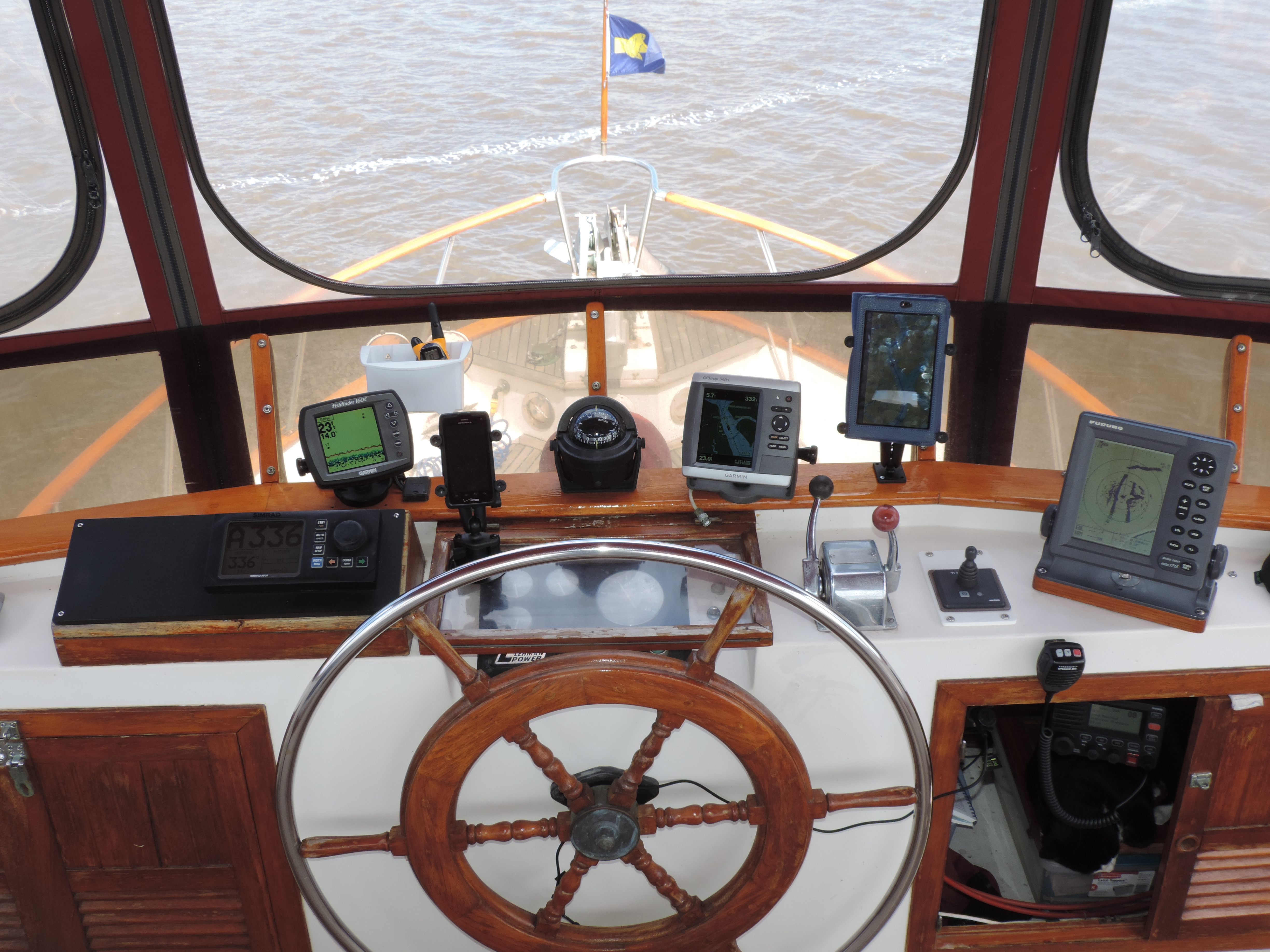
Navigation and other instruments
(3) Cell phone;
(4) Magnetic compass;
(5) Chart plotter;
(6 Nexus tablet displaying screen of navigation laptop running at the lower steering station;
(7) Furuno radar;
(8) Under cabinet – Lowrance Link-8 DSC VHF radio (new 2018);
(9) Under cabinet below – Ernie taking a break from his watch-stander duties.
(10) AIS VesperMarine XB-8000 is located under the counter. It feeds AIS data to the topside Garmin chart plotter and our computers running Polar Navy (formerly used Fugawi) and OpenCPN located at the lower navigation station.
Everything is connected electronically with a NMEA 2000 circuit installed in 2018 as part of the installation of a new Simrad NAC-3 autopilot, AP-48 display/controll unit, and Precision-9 solid-state compass. A new Lowrance Link-8 DSC VHF radio was installed at the topside steering area in 2018 and connected to the NMEA 2000 circuit.
At the lower steering station we are running Polar Navy and OpenCPN (as backup) (formerly used Fugawi) navigation software on a reconditioned Dell Latitude laptop being fed navigation and AIS data from a VesperMarine XB-8000 AIS via WiFi and a USB cable (WiFi for Polar Navy; cable for other navigation software). Everything connects to our boat-wide WiFi system. The AIS data (other boats/ships within 12-15 miles) dislays on the laptop via the navigation software. Consequently, we have the ability to display AIS data at the lower steering station on the laptop, and at the upper steering station on the chart plotter (directly from the VesperMarine XB-8000) and on the a tablet (via the VNC connection to the WiFi/laptop).
The VesperMarine XB-8000 also transmits our position frequently so other ships/boats with an AIS receive can see us in real time. The same information is retransmitted to MaineTraffic.com via a cell phone app where anyone with an internet connection can follow us, although not in real time as is the case with the direct AIS transponder.
Bob:
I assume that if this is my only AIS output, that I need a multiplex or some such thing to get the NMEA to be wifi:
NMEA Output: 38kbaud VDM, VDO, RMC, ALR
Right?
Thanks.
Hi, Mike. If your AIS doesn’t output a WiFi signal then I’m not sure what you do to get it but I know it can be done using the NMEA output. My AIS transponder (VesperMarine) outputs in all the NMEA protocols, USB, and Wifi, so it was easy.
Additionally, if you’re just going to a laptop then to a tablet, you can use the existing NMEA outputs to go directly to the laptop via an adapter (not a multiplexer). Then with the laptop and the tablet connected to your boat’s WiFi you can use VNC software to display the laptop’s screen on the tablet.
OMG so smiling, work with Judy and my guy Gary is going to go NUTZ with this sight, so informative and your photography is spot on!! We can’t wait to retire to the water! 🙂 So thankful to have met your Judy!!