Here are just a few facts summarizing our incredibly beautiful cruise around the eastern United States (sometimes referred to as the “Great Loop”). These facts reflect the cruise as we did it this trip; there are a lot of variations which will change some of these facts. We enjoy anchoring whenever we can, but we sometimes need to stay in a marina (such as when we needed groceries and there were no anchorages available, needed to rent a car to drive to another location, or left Sanderling in a marina waiting for favorable weather). As the saying goes, your mileage may vary.
We started this cruise on May 1st at our “home port” at Patrick Air Force Base, Florida. We had already traveled the east coast of the United States through New York City a number of times, and had been on the Erie Canal twice in the past; we had already cruised the Thousand Island area of the St. Lawrence River, the Rideau Waterway, the St. Lawrence River to Sorrel, the Chambly Canal and the Richelieu River, and through Lake Champlain, so our initial goal this time was to get to the beginning of the Trent-Severn Waterway at Trenton, Ontario, Canada, before the middle of June – which we did. We then spent approximately two additional months in Canada working our way through the Trent-Severn Waterway, Georgian Bay and the North Channel taking our time to enjoy the sights as they unfolded.
Weather seemed to be a huge factor throughout this cruise. Only a day and a half underway we had to stay at anchor in Daytona Beach, Florida, for two days waiting for torrential rain and wind to subside, then were able to proceed only a short distance to Marineland when it did. We delayed our arrival at Waterford to kill time while the water on the Erie Canal subsided enough to allow the canal to reopen and the backlog of boats to disperse, and then had to speed up once we were in the Erie Canal in order to get to the western slope and near Lake Oneida before more rain threatened to close the eastern portion of the canal, again. We only had a few days while in Canada when we had to wait out high winds, but there were about 8-10 days where we didn’t move because of high wind warnings. Lake Michigan upheld it’s reputation; we moved slowly down the eastern side of the lake ducking into harbors of refuge to wait out high winds and seas. All went well through the inland rivers, except our insurance provided that we could not proceed south of a certain line of latitude until the end of hurricane season (November 1st) so we could not get onto the Tennessee River heading to Chattanooga until after the magic date since it dipped below that line for a short distance before turning northward above the line; consequently we killed a couple of weeks in a marina in Clarksville and drove home for a short visit. Once we reached Mobile, Alabama, weather again had a dramatic affect on our cruising. We stayed in a marina south of Mobile for four days waiting for the wind to die down to acceptable levels so we could get across Mobile Bay. When we got to Apalachicola the weather windows for crossing the Gulf were fewer and farther between, and we wanted to see some of the Big Bend area where the water was now too low due to winter winds to allow us to enter some of the areas we wanted to see. We left Sanderling in a marina in Carrabelle for three months while we waited for decent weather to return. Bottom line: you can control a lot of things during a cruise, but not the weather!
An interesting feature of this particular cruise, and any cruise through Canadian waters, is the number of locks encountered. Here’s a rough count of the locks and other forms of vertical boat movement we encountered on this cruise:
Lifts and Locks:
- – Dismal Swamp Canal, North Caroline/Virginia = 2
- – Troy, New York, Federal Lock = 1
- – Erie Canal to the Oswego Canal = 22
- – Oswego Canal (to Lake Ontario) = 7
- – Trent-Severn Waterway – locks = 43
- – lifts = 2
- – marine railway = 1
- – Illinois Waterway (Lake Mich to Miss River) = 8
- – Mississippi River (to the Ohio River) = 2
- – Ohio River (to the Cumberland River) = 2
- – Cumberland River (to Nashville) = 2
- – Tennessee River (to Florence, Alabama) = 2
- – Tenn-Tombigee Waterway = 10
- – Black Warrior-Tombigbee Waterway = 2
- – Okeechobee Waterway = 7
Total Locks/Lifts = 101
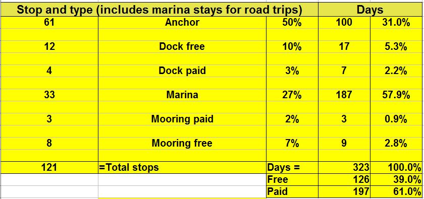
Number and type of stops along the way:
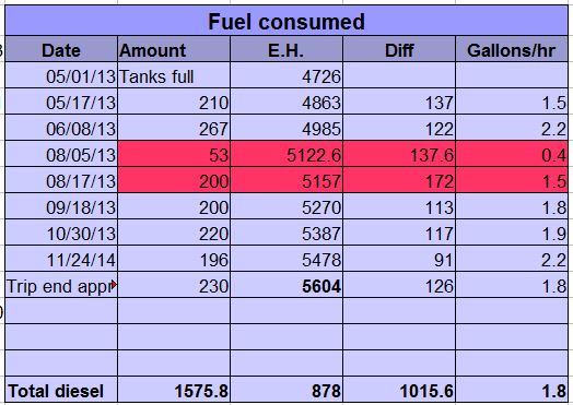
Fuel consumed and gallons per hour burn rate:
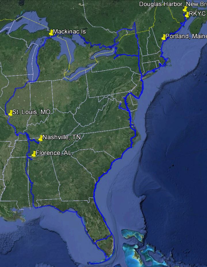
This cruise filled out our cruising map for the Great Loop. If you’re not familiar with what is commonly referred to as the “Great Loop,” here are the details from a screen shot of google earth showing actual traks from our gps (left-click on the image for a better view):
We’ve been working our way around the United States and Canada since 1997. Side trips have included many rivers along the east coast of the United States (St. Johns River to Sanford, Florida; James River to Richmond, Virginia; Potomac River to Washington, DC; the Cumberland River to Nashville, Tennessee; the Tennessee River to Florence, Alabama), NYC to Maine and the Bay of Fundy, and the Florida Keys to Dry Tortugas (70 miles west of Key West).
I’ve enjoyed reading your blog and website and am envious of your journey. My husband and I have not been coastal boating for long. We bought a 25 Sea Ray Sundancer, in fall of 2012, sold it fall of 2013, and bought a 390 Mainship in January of this year.
We hired a captain to train us for several weekends and to also deliver the MS to us in NC from the Chesapeake area. The training money was well spent. Because of weather and work/family obligations we haven’t spent as much time on the water as we’d like but, even so, are beginning to feel more comfy operating in good weather on the ICW.
We are interested in learning about anchoring but are more than a bit nervous about it. I think it’s the thought of troubleshooting in the middle of the night that makes my eyes bulge! Any suggestions for getting started and learning the basics so that troubleshooting isn’t just a random “Chinese Fire-Drill”? We’re hoping to one day cruise the Loop; anchoring would definitely be budget friendly.
Thanks! Vicky