Project: Refinish an interior teak deck

This process was recommended by a very knowledgeable boater on Trawlers and Trawlering List who refurbished Grand Banks fast trawlers. It made our interior teak & holly decks look like new.

Day—

1-Sand to bare wood with 60 and 150 grit paper then 2 coats of CPES and dry. Don’t try to remove all the deep dings and dents; some will remain and only you will notice them when the project is completed.

2-Sand with 220, then CPES – 1 coat until tacky, then 1 coat Captains Varnish

3-Captains – 1 coat

4-Captains – 1 coat

5-Sand with 220 – Captains – 1 coat

6-Captains – 1 coat

7-pour Captains into still-open seams and brushed across seams in attempt to fill (will probably not be totally successfully)

May need more very light sanding and more Captains to obtain the appearance you want. If want satin finish, do not sand final coat.

How to remove bungs from teak

There’s a trick to removing bungs and the underlying screws! Most bungs are 3/8″ or the next increment smaller. You’ll want to get a large “nail” slightly smaller than the bung (for a 3/8″ bung, get a 5/16″ “nail” or bolt). Cut the pointy end off the nail so you have a nice flat surface. Place the nail in the center of the bung and give it a tap with a hammer; that creates an indentation in the bung with the surrounding wood still standing proud and frees up the edge of the bung. Then using a small drill bit (no bigger than 1/8″) drill a hold in the center of the bung down until it bottoms out on the underlying screw (the bit will stop when it hits the screw). Position a construction screw in the hole and using an electric drill screw the construction screw down the hole you drilled; it will bottom out on the underlying screw and lift the bung right out of the hole! Any remaining bung material in the hole you can get out with an awl or small screw driver.

Then you you’ll have access to the underlying screw. It will probably be a Phillips head screw on an older boat; if you catch a bad break it will be a standard single channel (they’re much harder to remove). With a Phillips head you can take a Phillips head bit and set it on the screw into the X channels and give it a good hard tap with a hammer which will loosen the screw in the hold and break it away from any “glue” that might have been used to put it in place and also gouges out any leftover material in the X channels; once you’ve done that it should back out relatively easily. This should work (based on my experience) about 90% of the time; the remaining 10% of the time you may have to drill out the screw or use a screw extractor to “grab” the screw and back it out.

MV Sanderling has been sold

On January 14, 2021, Sanderling was turned over to her new owner who has taken her to a marina just over the Florida/Alabama boarder on the GICW.

We will continue to update our blog with information about trawlers and cruising in trawlers from time to time. Meanwhile, you might want to subscribe to the Trawlers-and-Trawlering email list (T&T List) to ask questions or learn more about boating from some very knowledgeable and experience people. You can subscribe to T&T List by sending an email to trawlers-join@lists.trawlering.com.

After almost 25 years, the Trawlers and Trawlering list is closing. You can download the archives from the T&T List here.

Navigation instruments/equipment

Some of you may be curious about the various navigation instruments (and others) that we are using aboard Sanderlng, so this will provide a little explanation.

This is a photo of our topside steering station when we were underway on May 7th, 2013 (various instruments have since been upgraded). The instruments, from left to right, are:

(1) Black rectangle – Simrad auto pilot display console and controls (new 2018);
(2) Upper right of autopilot – fish/depth finder;

Navigation and other instruments

Navigation and other instruments

(3) Cell phone;
(4) Magnetic compass;
(5) Chart plotter;
(6 Nexus tablet displaying screen of navigation laptop running at the lower steering station;
(7) Furuno radar;
(8) Under cabinet – Lowrance Link-8 DSC VHF radio (new 2018);
(9) Under cabinet below – Ernie taking a break from his watch-stander duties.

(10) AIS VesperMarine XB-8000 is located under the counter. It feeds AIS data to the topside Garmin chart plotter and our computers running Polar Navy (formerly used Fugawi) and OpenCPN located at the lower navigation station.

Everything is connected electronically with a NMEA 2000 circuit installed in 2018 as part of the installation of a new Simrad NAC-3 autopilot, AP-48 display/controll unit, and Precision-9 solid-state compass. A new Lowrance Link-8 DSC VHF radio was installed at the topside steering area in 2018 and connected to the NMEA 2000 circuit.

At the lower steering station we are running Polar Navy and OpenCPN (as backup) (formerly used Fugawi) navigation software on a reconditioned Dell Latitude laptop being fed navigation and AIS data from a VesperMarine XB-8000 AIS via WiFi and a USB cable (WiFi for Polar Navy; cable for other navigation software). Everything connects to our boat-wide WiFi system. The AIS data (other boats/ships within 12-15 miles) dislays on the laptop via the navigation software. Consequently, we have the ability to display AIS data at the lower steering station on the laptop, and at the upper steering station on the chart plotter (directly from the VesperMarine XB-8000) and on the a tablet (via the VNC connection to the WiFi/laptop).

The VesperMarine XB-8000 also transmits our position frequently so other ships/boats with an AIS receive can see us in real time. The same information is retransmitted to MaineTraffic.com via a cell phone app where anyone with an internet connection can follow us, although not in real time as is the case with the direct AIS transponder.

Underway Southbound – 2015

Southbound!

Follow us on MarineTraffic.com – just search for Sanderling and then select the pleasure boat registered in the United States.

September 21, 2015 (Monday)

Judy returned from Kansas on Thursday night, September 3rd, and Bob met her at the bus station in Portland after having dinner with Norm and Nancy at the Snow Squall Restaurant. On Friday we did some final shopping and prepared for our departure the next day. We did depart South Freeport on Saturday morning, September 5th, heading south and are now in a Navy-operated marina at Solomons, Maryland, having arrived here on Saturday, September 19th, two weeks to the day after departing South Freeport, Maine. We had dinner the last night with friends Norm and Nancy who were kind enough to meet us at the Enterprise Rental location in Portland on Friday afternoon, then drive us to Freeport where we had a great dinner together at the Tuscan Brick Oven Bistro – the pizza was super! Then Norm and Nancy drove us back to Straut’s Point Wharf marina where we said our goodbyes and dinghied back to Sanderling just before sunset. We departed South Freeport the next morning (Saturday),

September 5, 2015 (Saturday)

We dropped the lines to the mooring at 0625 and were underway – heading home! As much as we enjoy cruising in Maine, the weather was turning “fallish” and the temp this morning was 52F – too cold for our Florida blood. We cruised past Cliff Island and into the Atlantic Ocean, passed Cape Elizabeth at 0855 (Norm and Nancy’s summer home) and enjoyed a relatively calm day on the water with the sun shining, and at 1500 had our lines to the dock at the Portsmouth Naval Shipyard Marina Back Basin (actually in Kittery, Maine). We had quite a battle with the flood tide as we crabbed sideways into our assigned slip, but with the help of two other boaters were able to get the lines secured without difficulty.

Day: 58.4NM/67.1SM   –   8H35M
Trip: 2020.4NM/232.6SM   –   336H20M

While in Kittery we replenished our food stuffs from the small commissary, Bob took some photos of the now vacant former Navy prison (U.S. Naval Disciplinary Command, as it was known in the late 60s), and Judy ran five loads (small) of laundry through our onboard combination washer/dryer. The weather was pleasant with the sun shining every day and no fog!

On Monday, September 7, 2015, we cast off the lines at slack tide and made our way down the Piscataqua River and out into the Atlantic. Today we were heading around Cape Ann (since it was a holiday we didn’t want to risk tangling with “weekend” boaters in the Annisquam River/Canal) to Gloucester, where we are going to fill up with diesel fuel at about $2.00 per gallon! The ocean getting to Cape Ann was fairly smooth, but as we started to round Cape Ann the wind picked up from the south/south-west and the waves became a bit rough until we reached Gloucester Harbor. As we approached Gloucester, Judy contacted the Harbormaster’s office and got a mooring for the night. We decided to take the mooring while it was still available and get fuel early in the morning before departing, so at 1300 we picked up a mooring at the junction of the two channels into the eastern end of the harbor. We had dinner aboard and a relaxing evening.

Day: 37.2NM/42.7SM   –   5H55M
Trip: 2057.6NM/2364.4SM   –   342H15M

Tuesday, September 8, 2015, we left the mooring at 0715 to shift location to the fuel barge, filled with 202.4 gallons at $2.14 (with tax), and were on our way by 0755. We had a straight shot across Massachusetts Bay to Plymouth, Massachusetts (remember Plymouth Rock, such as it is), and the bay smoothed out about an hour out of Gloucester. As we approached Plymouth the weather forecast for the night was for very light winds from the south, so instead of going about four miles out of our way into Plymouth Harbor, we anchored in Warren Cove which is right on the coast a few miles east of Plymouth, in an area well protected from southerly winds. The night was quiet!

Day: 41.5NM/47.7SM   –   5H55M
Trip: 2099.1NM/2412.0SM   –   358H35M

The next morning, Wednesday, September 9, 2015, we timed out departure from Warren Cove to put us in the Cape Cod Canal with favorable current. We were underway at 0740 and at 0955 we entered the canal with the current which had turned westward at 0730. When we got to the Buzzards Bay (west) end of the canal we encountered 4-6 foot standing waves in the channel of the canal leading out into Buzzards Bay. The boat took water over the bow which was blown over the top of our bimini (which stands 15 feet above the water) even though we slowed down to the point of only going 6 knots through the water with the rapid current pushing us. It quickly became apparent that we couldn’t tolerate the hobby-horsing for long so we slowly worked our way over to the south side of the channel without broaching (turning sideways to the waves) and into some slightly less rough water (no standing waves) out of the channel. From there we were able to motor to the south a short distance to a channel running back east and from there to a small cove with some substantial unused moorings (Judy referred to them at “guest” moorings) that looked as though they hadn’t been used for awhile, and at 1155 had taken one. We decided to spend the night there and rest up from our ordeal in the canal. No one came out to ask us to move, and we had another peaceful night, out of the current and with only a little wind.

Day: 28.7NM/33.0SM   –  4H15M
Trip: 2127.8NM/2445.0SM   –   352H50M

We left the “guest” mooring at 0640 on Thursday, September 10, 2015, heading to Bristol, Rhode Island, for several nights to visit with friends Helga and Vic. The trip down Buzzards Bay was punctuated by fog, heavy rain with lightning and thunder, and some 3 foot waves during the rain storms, but we turned the corner into the Sakonnet River in the rain at 1120 and at 1415 had lines to a mooring at Bristol Marine, in Bristol, Rhode Island. Judy was amazed at the number of sailboats on moorings in Bristol Harbor; included were a number of Nathanial Herreshoff designs maintained in good shape by the owners who love them!

Day: 51.0NM/58.6SM   –   7H35M
Trip: 2178.8NM/2503.6SM   –   360H25M

We were in Bristol, RI, for two nights, and spent the day on Friday with friends Helga and Vic. With them we walked the grounds of Blithewold and they showed us the newly renovated Bristol Art Museum in which they had a major roll in arranging the long-term lease, soliciting major contributions and donors, meeting with architects, and doing a lot of the interior work. They have received a special award from Blithewold, and one of the galleries at the Art Museum is being named after them! We had an early dinner with Helga and Vic and two other friends from the 80s when Bob lived in Bristol, then Vic drove us back to the marina where we caught the last launch of the evening (around 1900) back to Sanderling.

Saturday morning, September 12, 2015, dawned overcast but calm, and we were underway at 0605 heading for the Long Island Sound. We turned out of Narragansett Bay rounding Point Judith at 0945, and at 1205 Watch Hill and it’s beautiful homes was to starboard as we entered Long Island Sound north of Fisher’s Island to avoid the higher tidal currents at the Race or at Plum Gut – the water was nonetheless turbulent as we crossed the boundary between ocean and sound. We continued westward along the north shore of the Sound to Duck Island about four miles west of the Connecticut Rive along the north shore of the Sound. Duck Island is a very small island with long breakwaters extending from the island to the west and to the north, making a good anchorage when then wind is from the east or south. The NOAA forecast for Saturday night was for winds 10-15 MPH from the southeast, so this was an ideal spot. When we arrived at 1730 there were four sailboats and three power boats anchored in various locations in the protected area. We picked a good spot with plenty of swinging room in 8 feet of water and let out 125 feet of chain; we backed down at 1200 rpm to make sure the anchor was holding well.

Day: 74.4NM/85.5SM   –  11H25M
Trip: 2253.2NM/2589.1SM   –   372H10M

As the afternoon turned to evening several boats departed the area as the wind (and waves) increased. By 2000 it was apparent that NOAA and the other weather services had badly misjudged the wind on the Sound, although it continued out of the southeast and later from the east. Here’s what Judy wrote in the log about our experience that night:

What a night! The weather folks, including NOA really missed this one! Winds were predicted 10-15 with gusts to 20 [MPH] – we had steady winds of 30-35 for about 6 hours! Anchor alarm was sounding [GPS location issue], winds were terribly loud, boat was swinging, cats were scared, sailboat next to us had sail come loose at 0200 in the morning! Bob got about 4 hours of sleep; Judy got about 2! Wild night!

The wind started slacking about 0400 (I think that’s when Judy went to bed for some much needed sleep) and by 0700 they were still gusting in the 20s, but but 0800 they had slacked even more. The anchor was really buried in mud/sand and we had to use the boat’s forward momentum to break it loose as the windlass couldn’t pull it out without help.

We were underway at 0805, Sunday, September 13, heading across the Sound and to the west to Port Washington. The wind continued from the east as did the tidal current for a good part of the day, so we made some good time. As we approached Fort Washington/Manhasset Bay the current turned against us and with the easterly wind the water again became rough and we slowed down a bit. We had our lines to one of the 18 free-for-two-days moorings in Manhasset Bay at 1825.

Day: 67.4NM/77.4SM   –   10H20M
Trip: 2320.6NM/2666.6SM   –   382H30M

Weather in the New York/Long Island area was poor on Monday (windy), so we stayed the day on the mooring. Later in the afternoon we took the water taxi to Port Washington and ate an early dinner at Diwan, a great Indian restaurant recommended by the water taxi driver. After dinner we got a few items at a nearby grocery store and then hailed the taxi by VHF radio for a ride back to Sanderling.

Port Washington mooring field

Port Washington mooring field

Tuesday, September 15th we were underway at 1045 in order to catch the fair ebb current at 1130 on the East River through New York City. Interestingly, although Long Island Sound and the East River are connected, Long Island Sound floods from east to west and the East River floods from west to east – the flood tides meet on the western end of Long Island Sound and the tide charts actually have current arrows pointing at each other in the area in the area between Frogs Neck and Manhasset Bay! Ebb tide is just the opposite in the two bodies of water.

We were traveling at 9.1 knots through Hell Gate (not bad considering that the current alone can reach 6 knots) and shot under the Brooklyn Bridge at 1325 and under the Verrazano Narrows Bridge at 1415. We continued south out of New York Harbor and anchored on the west side of Sandy Hook just north of the Coast Guard station at 1535. The night was quiet!

Day: 33.4NM/38.4SM   –   4H50M
Trip: 2354.0NM/2704.9SM   –   387H20M

The next four days were a race to get to Solomons, Maryland, before forecast winds with gusts near 30 from the north started on Sunday. So we were underway before we could see the surface of the water at 0545 on Wednesday, September 16, following the “bread-crumb” trail on the chart plotter out of the anchorage and around the western side of Sandy Hook. By the time we reached the northern side we could see the water and make out the navigation aids without the help of a spot light. We ran down the east coast of New Jersey to Atlantic City where we tied to the dock at Gardners Basin and went ashore to eat dinner at the Back Bay Ale House, filled the water tanks, had a good night’s sleep, and were underway at 0655 on Thursday. As we were getting ready to cast off lines, we discovered that our bow line had been cut with a knife during the night and was dangling in the water; fortunately our spring lines were holding us in place as the large clam boats passed on their way out to vacuum the bottom for clams! In the six times we’ve stayed at Gardners Basin, this is the first time that we’ve experienced any sort of vandalism – it’s hard to tell if it occurred from someone on the dock or in a small boat. The line was definitely cut with a rather dull knife!

By the time we reached Cape May we decided we’d continue on into Delaware Bay and find an anchorage along the north shore south of the nuclear power plant. We exited the Cape May Canal into Delaware Bay at 1305 and anchored at Cohansey Cove at 1815 in 11 feet of water. The current from the Cohansey River was causing the water in the area to move rather quickly into the Bay, and I misjudged the speed at which we were backing when we set the anchor. Consequently, the anchor chain snapped tight as the anchor held firm (very unusual) and the block supporting the anchor chain stopper cracked near the base between two layers of wood and fiberglass. Not a catastrophy, but another repair to think about.

Here’s what I wrote in the log about the night at Cohansey River entrance:

Terrible night with wave induced rolling along with 15 MPH wind from the south until after mid-night, then continuing with only 2 short periods of sleep! Tide and river current interaction?

We were underway at 0625 on Friday, September 18th, after again having to use forward motion of the boat to free the anchor – it was buried deep in mud (guess that’s why it held so quickly when anchoring). The current on Delaware Bay was against us and we were making only 4.5-5.0 knots most of the way to the Chesapeake and Delaware Canal, then the current in the canal was against us as well. When we entered the canal at Reedy Point Judy spotted an eagle perched on a short tower. We followed a sailboat who seemed to know what he was doing along the northern bank of the canal, and found that the current was about 0.4 knots less close to the bank – a good trick to keep in mind in the future. We exited the canal at 1310 and anchored in Bodkin Bay (just off the southern shipping channel into Baltimore) at 1620 in a beautiful, quiet location.

Day: 71.8NM/82.5SM   –   11H55M
Trip: 2575.9NM/2955.9SM   –   422H20M

When we awoke on Saturday morning, September 19, 2015, the fog had descended. Nothing as thick as we experienced in Maine, and it soon lifted enough that we could see several other boats anchored nearby and eventually the shoreline about 1/4 mile away. We were underway at 0735, under the Annapolis Bay Bridge at 0920, turned into the Patuxent River at 1455 at Cove Point, and had our lines to the dock at Point patience Marina (Navy Recreation Center, Solomons) at 1615. We’re going to stay here for a few days while Judy drive home for some professional meetings and to work at “her” hospital. Bob is going to work on boat projects and take care of the cats!

Day: 54.8NM/63.0SM   –   8H40M
Trip: 2630.7NM/3022.9SM   –   431H00M

We had dinner on Sunday evening with Jennifer and Don from Edgewater at the CD Cafe – one of our favorites in this area! They departed shortly after dinner as they both teach the next day in high schools south of Annapolis.

Judy picked up a rental car from Enterprise in Lexington Park on Monday morning, we did some quick shopping, and then around noon she headed south to Florida.

While Judy was in Florida, Bob worked on maintenance items and had dinner on the following Saturday with Jennifer and Don. We ate at Stoney’s Kingfisher restaurant and I had “original” crab cakes. They were just as good as I remembered; this is the only place I get crab cakes on the east coast – nowhere else compares!

Judy returned from Florida on Sunday evening. While she still had the rental car we did some last minute grocery shopping. On Monday she turned in the rental car, then we got Sanderling ready to get underway, filled the water tanks, and ate dinner with dock friends at Boomerang’s Restaurant – good burgers and ribs.

The weather forecast for Chesapeake Bay for the next two days was decent; by Wednesday evening the weather was deteriorating – waves on the lower Chesapeake and Hampton Roads were forecast to reach 5-6 feet on Thursday – not a day we would want to be crossing into Norfolk from any anchorage on the northern side of the area. Our goal was to be through Hampton Roads and into Norfolk and into a protected anchorage by Wednesday afternoon.

On Tuesday, September 29, 2015 we were underway from Point Patience Marina at 0635, headed out the Patuxent River, and turned south into Chesapeake Bay. The tidal current was with us and we made good time; even the 15 mile leg from Point No Point Light to Smith Point Light (across the mouth of the Potomac River) was relatively calm. Once we had Smith Point Light abeam the waves picked up to 2-3 feet from the south-east, and the ride from there to the Piankatank River (Stingray Point) was rough; we had to tack back and forth to lessen the impact of the waves which resulted in a much longer leg than originally planned. We anchored in the rain in Godfrey Bay on the south side of the Piankatank River at 1630, with some protection from the waves and the main body of Chesapeake Bay. After a few hours the smaller wind generated waves died down and the rest of the evening and night were quiet and pleasant.

Day: 62.0NM/71.2SM   –   9H55M         Trip: 2692.7NM/3094.1SM   –   40H55M

Wednesday, September 30th, dawned overcast so it wasn’t as light as early as we had hoped. We got underway in the dark at 0630, with Judy following our “bread crumbs” on the chart plotter from our entrance into the river the day before. Several other boats were leaving the river at about the same time, so we had a small procession heading back into Chesapeake Bay and turning south toward Norfolk and Hampton Roads, about 35 miles away. We had planned a route into a small anchorage in the Lafayette River, just south of the naval base, as a good place to stop for the day (and get off the Bay), but with a nice push from the ebb tide for the first couple of hours and a boost in our engine’s RPMs we made good time down the Bay. By 1000 it was apparent that we could get further than planned, and we extended our route into the Dismal Swamp Canal. We were also getting weather forecasts discussing hurricane Joaquin, so we wanted to get not just to a protected anchorage but into a good hurricane hole in case Joaquin developed into a major threat or even if he dwindled into a bad nor’easter. Elizabeth’s Dock in the Dismal Swamp Canal became our goal.

We passed Old Point Comfort and entered Hampton Roads at 1215 after having a foul tidal current for several hours. The chart plotter showed that we should be at the mouth of the small river leading to the Dismal Swamp Canal (Deep Creek Lock) at 1500 – the last lock up for the day is at 1530, so we would have to run the three miles up Deep Creek in 30 minutes – should be plenty of time. And we did. We got to the junction of the ICW and Deep Creek at 1500 after sailing through Norfolk with no delays for bridges (most low bridges have been replaced with high bridges, except for the three railway bridges), turned into the creek, and arrived at Deep Creek Lock at 1520! The lock tender was cutting the grass at the lock so didn’t get to us until about 1530, then had to lower the water in the lock. By the time we entered the lock, chatted with Robert, exited, and hung a sharp right we had our lines to Elizabeth’s Dock at 1610.

Day: 58.7NM/67.55SM   –   9H00M      Trip: 2751.4NM/3161.5SM   –   449H55M

We will be staying here at Elizabeth’s Dock for a few days until hurricane Joaquin gets sorted out. A large sailing cat came into the canal and moored to the dock at 1130, and it sounds like two more sailboats are currently entering the lock and have asked about mooring at the dock. We’ll soon have a storm party!

October 5, 2015 (Monday)

After five days at Elizabeth’s Dock at Deep Creek Lock in the north end of the Dismal Swamp Canal, the winds are finally slowly abating and Wednesday looks like a good day to cross Albermarle Sound. We’re going to depart the dock tomorrow morning (Tuesday) at around 0900 and continue south through the canal and out at South Mills; then we’ll anchor in the Pasquotank River north of Elizabeth City for the afternoon and evening. We hope the forecast holds true; by Wednesday the wind should be out of the north at 10-15 MPH and conditions on Albermarle Sound should be conducive to a decent crossing into the Alligator River where we’ll anchor for the night just before entering the Alligator-Pungo Canal. We’ll stop for fuel the following day (Thursday) at Dowry Creek Marina on the Pungo River just east of Bellehaven, then go a little further and anchor for the night, again. With any luck the various rivers and sounds we have to transit for the rest of the week will be gentle and allow an uneventful passage.

October 12, 2015 (Monday)

Here’s where we’ve been for the past week:

Tuesday, October 6th, departed Dismal Swamp Canal and anchored for the night at Goat Island in the Pasquotank River.

Wednesday, October 7th, finished the Pasquotank River past Elizabeth City, NC, and across Albermarle Sound (fairly calm) to anchor for the night near Tuckahoe Point, just before the Alligator-Pungo Canal.

Alligator River Deep Point anchorage

Alligator River Deep Point anchorage


Thursday, October 8th, transited the Alligator-Pungo C

anal into the Pungo River, stopped at Dowrey Creek Marina for 254 gallons of diesel fuel (no water available because their well had flooded with all the recent rain), then continued on a short distance and anchored in Pungo Creek for the night.

Washington NC free town dock

Washington NC free town dock

Friday, October 9th, finished the Pungo River and entered the Pamlico River where we turned westward and cruised the 30 miles upstream to Washington, North Carolina (Little Washington), where we filled the water tanks at the “shopping dock” at no charge, then were directed to a 48-hour free dock a short distance away. Had a nice time in this quaint little town incorporated in 1776 (the first town in the US named after George Washington). Had the best shrimp and grits at a nearby restaurant (perhaps second to Bob’s very own). We stayed for two nights.

Sunday, October 11th, returned the 30 miles back down the Pamlico River and resumed the ICW track into Goose Creek where we anchored in Campbell Creek for the night.

Oriental NC Town Dock

Oriental NC Town Dock

Monday, October 12th, finished Goose Creek past the Coast Guard station and fishing boats, then into the Neuse River (got a little rough with following seas blown by 15 MPH winds from the NE out of Pamlico Sound). Continued up the Neuse to Oriental where, for the first time in eight or so visits, we were able to get a spot on the free town dock (free for 48 hours). Ernie (the young cat) had a cut that required the attention of a veterinarian, so Judy took him to one just two blocks from the town dock (this is a very small town, pop. 900); the cut required stitches to close, and we had Ernie back by mid afternoon, thanks to vet Sherri Hicks. Ernie is groggy and wearing a collar – you can only imagine how much he hates that!

Tomorrow, Tuesday, we’ll head to Morehead City/Beaufort and then west toward Camp Lejeune and Mile Hammock Bay where we’ll anchor for the night. OR, we’ll stop in Morehead City at the Sanitary Seafood Company dock and have dinner there, then head to Mile Hammock Bay the next day.

Water from the recent storms is still causing flooding in some of the rivers in South Carolina so we’re taking our time getting there. Forecasts indicate the water should be back to near normal by Thursday this week.

All is well!

Posted October 18, 2015

Ernie is almost back to his normal, rambunctious self (except for the shaved area on his butt where the hair is slowly growing out).

Cedar Creek

Cedar Creek

We left Oriental on Tuesday, October 13th as planned, at 0915 but only went as far as Cedar Creek (MM 187.7), about 8.3SM/7.2NM, where we anchored at 1030. We were able to anchor mostly out of the SW winds so had a fairly calm day at anchor catching up on work and reading. Ernie wore his collar at night, only, and kept Judy awake for a good part of the night dealing with his collar. During the evening the wind subsided and the forecast for Bogue Sound for the next day was good.

Day: 8.3SM/7.2NM – 1H15M      Trip: 2972.6NM/3415.7SM – 493H30M

We were underway from Cedar Creek (MM187.7) at 0735, Wednesday, October 14th, rounded the bulkhead at Morehead City (next to Beaufort) at 10:15, and turned into Bogue Sound. The dock at the Sanitary Fish Company had only one sailboat, but we decided to keep going since the Sound was fairly peaceful and we wanted to get further along our route south. Bogue Sound turned out to be a great transit; the wind and water were calm, and there were very few boats moving in our direction. We did pass several small working boats dragging nets in the channel, but they moved off to the side to let us pass. We anchored in Mile Hammock Bay at Camp LeJeune, North Carolina, just off the ICW, at 1550. During the rest of the afternoon we were joined by two other power boats (a trawler and a beautiful Legacy MK3 tug) and four sailboats (including Toby with CJ aboard with whom we shared the town dock at Oriental).

Day: 66.5SM/57.9NM – 8H15M    Trip: 3030.4NM/3482.2SM – 493H30M

We were underway at 0735, October 15, 2015, from Mile Hammock Bay (MM244.5), went through two bridges with minimal delays waiting for openings, then arrived at the Wrightsville Beach Bridge where the bridge tender would not open even three minutes past the normal on-the-hour opening at 1300 to let us and Second Option (a sailboat from Mile Hammock Bay the night before) get through – so we waited – and talked from boat to boat – and about 1330 a southbound commercial tug called the bridge for an opening. We hadn’t been able to identify the tug visually, but as soon as we heard it call the bridge we looked again, and sure enough, there was a small tug pushing what appeared to be a LCM – so we were able to join the parade and pass through the bridge at 1335 (25 minutes earlier than the “normal” bridge opening). We followed the tug (and Second Option) through the shallow spots between Wrightsville Beach and Snows Cut, with the tug grounding several times while leading the way and “dredging” the shallows! Just before Snows Cut, which leads to the Cape Fear River, we turned off into Carolina Beach and took a mooring ball at 1530. Second Option got to a mooring ball a few minutes earlier.

Day: 51.1SM/44.5NM – 7H55M     Trip: 3074.9NM/3533.3SM – 501H25M

From Carolina Beach mooring field it was a short trip through Snows Cut, down the Cape Fear River to Southport, then a short distance to the South Harbor Village Marina at MM 311. We had dinner at a nice Italian Restaurant (others would describe it as “excellent” but I’m not a big fan of Italian food, other than pizza) with Bill and Terri from Second Option.

Day: 16.9SM/14.7NM – 2H45M   Trip: 3089.6NM/3550.2SM – 504H10M

Today’s weather was questionable when we arrived at the marina, but we decided to wait until we awoke in this morning to decide whether to stay a second night at the marina – we’re glad we waited to decide; overnight the forecast changed from high, gusting winds, to fairly calm conditions on the ICW.

Barefoot Landing Marina,Myrtle Beach, SC

Barefoot Landing Marina,Myrtle Beach, SC

We were underway at 0730, October 17th, from the South Harbor Village Marina (MM 311.1), at 0835 we transited Lockwood Folly at mid-flood tide and saw no less than 8.7 feet of water depth. This is an area of shifting shoals with temporary buoys placed to help guide boats through the hazards. At 1330 we had our lines to the dock at Barefoot Landing Marina with the help of Nick, Bruce, and Jordan, where we are staying for two nights in order to do some grocery shopping and change the engine oil. This is a nice stop with a good variety of restaurants to choose from, and interesting people-watching among the crowds from the Myrtle Beach area who seem to frequent the Barefoot Landing shopping/entertainment area. Bruce gave us tickets for House of Blues where we heard a Bon Jovi tribute group playing to an enthusiastic crowd!

Day: 42.7SM/37.2NM – 6H00M   Trip: 3126.8NM/3592.9SM – 510H10M

Posted October 31, 2015

A quick summary of the past two weeks since Barefoot Landing Marina

Departed Barefoot Landing Marina on October 20, 2015; anchored in South Santee River (west branch) MM415.

Departed South Santee River on Wednesday, October 21st; anchored Church Creek (south of Charleston) at MM487

Departed Church Creek on Thursday, October 22, 2015; anchored Bull Creek (by Dufusky Island and south of Beaufort, SC) at MM566

Departed Bull Creek on Friday, October 23, 2015; anchored Walburg Creek (immediately off St. Catherine Sound) at MM619

Departed Walburg Creek on Saturday, October 24, 2015: anchored at Wallys Leg MM666.2

Departed Wallys Leg on Sunday, October 24, 2015; anchored Little Cumberland Island (west side) at MM693.3

Departed Little Cumberland Island on Monday, October 26, 2015; took a mooring ball at Fernandina Beach (just south of the Florida/Georgia border) at MM717

Judy drove home and to Orlando in a rental car for meetings; returned on Wednesday, October 28th

Departed Fernandina, Florida, on Thursday, October 29, 2015; took mooring ball at St. Augustine at MM777.9

Departed St. Augustine on Friday, October 30, 2015; anchored in north end of Mosquito Lagoon at MM862 (a long day – almost 12 hours underway)

Departed Mosquito Lagoon on Saturday, October 31, 2015; anchored in the Banana River just west of Port Canaveral at what would be MM902 except we’re no longer on the ICW.

Tomorrow we have about 15 miles to go to reach Manatee Cove Marina; we anticipate arriving around noon. It will take us most of the afternoon to get essentials from the boat to our home and get our home back in semi-living condition.

Underway Northbound -2015

2015-06-14 Sunday

After four months in the boat yard and almost two weeks getting things ship-shape (at least good enough), loading supplies and purchasing food, we cast off lines at 1415 Sunday, June 14, 2015, on our way toward Maine. Whether we make it that far with this late start only time will tell, but at least we’re going to make the effort. This will be our 13th transit of the Atlantic Intracoastal Waterway (ICW) so there’s not much we have to stop for on the way north; perhaps we’ll take more time when we head back south.

In the meantime, we’ll try to keep this blog up to date as much as possible (whenever we have a decent internet connection and time permits). For now, we anchored the first night out just south of the NASA railroad bridge near Titusville, and anchored the second night north of SeaBreeze Bridge in Daytona. We stopped short today so we could visit and have dinner with our friend who lives in Palm Coast – staying the night at Marineland Marina between Palm Coast and St. Augustine. Tomorrow we’ll continue heading north through St. Augustine and will probably anchor at Pine Island.

2015-06-23 Tuesday

Have a chance to update the blog. We went into Barefoot Landing Marina in North Myrtle Beach late yesterday afternoon and have a good WiFi connection via our antenna and router, so will do what I have time for before getting to work.

After leaving MCM, we anchored for the night just south of the NASA Railway bridge on the Indian River for the night. The next day, Monday, June 15th, we were underway at 0725 (the day was already hot) and anchoredat 1440 that afternoon at SeaBreeze Bridge in Daytona Beach, Florida. Had a quiet night with only one other boat coming into the anchorage. We had arranged to meet a friend from Palm Coast on Tuesday evening for dinner, so we were cutting our cruising days short so as not to arrive early. On Tuesday morning we were underway at 0730 and had lines to the dock at Marineland Marina by 1215, a cruise of only 32.9 miles and 4H45M! The air conditioning felt good after the heat of the last three days. We met Melissa (who presented us with various 30 amp and 50 amp electrical cords and a folding bike from her boating days on MV Fullstep) and then we went to an early dinner at a restaurant about five miles south of the marina (the only problem with Marineland Marina is that there are absolutely no facilities close at hand).

On Wednesday morning we were ready to move out. We departed Marineland Marina at 0650, transited St. Augustine (where we saw the Spanish Galeon Andalucia at the new docks) just south of the Bridge of Lions), crossed the St. Johns River at 1410, and at 1830 anchored at Cumberland Island, Georgia (mile marker 711), for a 90.2 mile , 11H40M, day!

On Thursday morning we were underway at 0720, overtook a “dredge train” with tug Rachael leading dredge Brunswick and tug George, passed through Little Mud River at near low tide where we saw a depth of 4.9 feet (mud bottom), and anchored at 1740 in Crescent River at mile marker 643.Had a very pleasant evening (although it was hot, with a nice breeze) and observed a brilliant moon, Jupiter and Venus in the same section of the sky just after sunset.

On Friday (June 19th) we were again underway at 0720, crossed the Savannah River into South Carolina after passing the same “dredge train” at Thunderbolt, Georgia, and anchored at Bull Creek (MM 565) at 1825, after a 78.6 mile, 11H05M, day! Since it was Friday, we grilled hamburgers for dinner!

The next day, Saturday, we were underway at 0715 and anchored in Church Creek (mm 488) at 1730, along with another DeFever trawler (this one heading to St. Petersburg, Florida.

On Sunday morning while doing a getting underway engine room check, I heard a drip-drip-dripping sound occurring about 3-4 times per second. No little aquatic animals nibbling at the hull, no leaking fuel – it was raw (outside) water leaking from a pipe on the engine heat exchanger. After checking the easy source first (a rubber hose) it was obvious that the leak was in the pipe itself. I wrapped it tightly with emergency tape (self-amalgamating tape), replaced the hose leading to the transmission oil cooler, and tested my handy work by running the engine and observing – no more leak! Even with that work we got underway at 0740. A check of the engine room about an hour later revealed no further leak, so we continued on through Charleston, South Carolina, past Mt. Pleasant and Isle of Palms, and anchored in South Santee River (mm420) at 1650 after 67.7 miles and 9H10M. It was unbelievably hot so we started the generator and then the two air conditioners; a short time later Judy said she smelled diesel fuel (her “smeller” is much more sensitive than mine) and when I checked the engine room the generator was leaking diesel fuel at the fuel filter/water separator housing. When I tightened the nylon plug less than a 12th of a turn, the plug snapped off at the base of the nut and fuel spurted out! Emergency generator shutdown, mop up diesel fuel (only a small amount), open windows, suffer with the heat!

Monday morning we were underway at 0620. On Sunday we had made reservations for two nights in a very nice marina in North Myrtle Beach anticipating a stop to take delivery of a new heat exchanger sent overnight FedEx on Monday from American Diesel in Virginia, install the new heat exchanger, and spend a cool night with the air conditioners running. Now it became a place to replace the heat exchanger and try to repair the leak in the generator. Shortly before we arrived at the marina we heard a loud pop and couldn’t determine what had happened – nothing had fallen from the mast, nothing seemed amis. Then Judy smelled propane and heard a hissing sound – it took us about 5 nanoseconds to determine that the propane line between the tank and the regulator had broken – and it took another 20 nanoseconds to turn off the propane. Now we had a third thing to fix in the marina (if we could find a new propane line). We arrived at Barefoot Landing Marina (MM 353) at 1630 after delaying an hour for a rather severe thunderstorm with high winds to pass to the west of us – it never came far enough east to be of any concern. It was nice to have air conditioning, get off the boat, walk around, and enjoy a meal ashore (we ate at Joe’s Crab Shack), oh yes, and have some ice cream!

On Tuesday the marina manager drove us to three different locations to shop for boat parts and a few groceries. The heat exchanger was delivered by FedEx before we left for shopping. By the time we returned it was too late to change out the heat exchanger, but I was able to fix the fuel leak in the generator (I hope), and replaced the  propane tank hose. The heat exchanger can wait until the next marina1

Tomorrow (Wednesday) we head out again and probably won’t stop until we make a short stop for groceries at the northern end of the Dismal Swamp Canal in Virginia.

 June 27, 2015 (Saturday)

A quick update while we have some surreptitious WiFi!

After Barefoot Landing for two days (where we were able to do some grocery shopping, I got the propane line part and fixed the generator so we can have air conditioning), we made good time northward. First night at Caroline Beach, North Carolina (just north of the Cape Fear River) at mile 295, then Mile Hammock Bay at Marine Corps Base, Camp LeJeune, NC, at mile 244, (where we stayed two nights to wait for better weather on Bogue Sound and also to allow Judy to put in a full day’s work on a case she had with a deadline), and today to an anchorage just off the Neuse River in South River (and a little creek off South River) mile 178. Storms with high winds are predicted for tonight and part of tomorrow, so we wanted a good anchorage with a lot of protection from the wind from the southwest, and this looked like just the place. We pulled into the little creek in a torrential downpour, but it soon let up and Judy was able to work the anchor windlass from the foredeck to get town 75 feet of chain in seven feet of water! We backed down on the anchor at 1200 rpm and we held firm – that should hold us through the forecast 40 knots of wind!

Only time will tell whether the storm materializes tonight, but the weather forecasts for this area for the past several days have been quite accurate, so we’re planning on rain and wind with gusts to around 40 tonight. Will let you know next time I’m able to update the blog

The first morning we were at Mile Hammock Bay we alerted the Coast Guard to a small skiff calling for help over the VHF. We could hear them, but apparently the Coast Guard could not, and after several attempt to establish a location for their boat via VHF, Judy called the Coast Guard using her cell phone. Shortly after that the Coast Guard attempted to contact the boat, but for whatever reason the boat wasn’t responsive but yet still continued calls for assistance at short intervals. The boat indicated they had taken on water in New River Inlet (just south of Camp LeJeune) and needed help. Hard to tell whether a call like that is a hoax or the real thing, but later in the morning the Coast Guard called Judy’s cell and informed her that SeaTow had found the boat full of water and washed up ashore and that everyone aboard was safe – they thanked Judy for her assistance. Nice work!

Just checked the weather forecast and WindGuru and while there are storms in the area the wind forecast isn’t as severe as it was four hours ago – now forecast to be SW with gusts to around 28! Much better than 40! And the wind forecast for tomorrow is just as good – generally less than 10 with gusts to around 20.

Wednesday, July 1, 2015

We have a little catching up to do and tonight we have WiFi so I’ll bring you up to date.

We left Big Creek on South River (off the Neuse River) on Sunday, June 28th, at 0945. The late start was caused by another small leak in the transmission oil cooler which Bob discovered at about 0615 as he was doing the morning engine room check. A little brushing with a wire brush, some JB Weld, and three hours later – we were ready to go! The Neuse River was a bit rough with winds out of the west at about 15 knots, and most of the day through the Pamlico River and the Pungo River was much the same. We continued on through the Pungo-Alligator River Canal to Tuckahoe Point at MM104, arriving at 2005 to a beautiful sunset and calm winds just about the time the pizza (which had been baking in the oven) was ready to eat! We spent a quiet night at anchor with no major wind, no storms and no bugs along with another trawler and a sailboat which were there prior to our late arrival.

On Monday, June 29, 2015, we were underway at 0635 after the first cool night of the cruise! No problems to deal with in the engine room! We were thru the Alligator River Bridge at MM84.2 at 0915, crossed Albermarle Sound with a 10-15 knot wind on our port quarter making the ride a little rough, and entered the Pasquatank River at 1145. We passed by Elizabeth City (and their terribly short, but free, finger piers) and anchored at Goat Island MM45 at 1515. The rest of the day was fairly pleasant – Judy working and Bob got a nap (a rarity these days).

Tuesday, June 30, we were underway at 0615 in order to arrive at South Mills Lock of the Dismal Swamp Canal in time for their 0830 lock thru (the first of four of the day). About the time we reached the narrow part of the river we were hailed by another boat also heading to the lock; we arrived in plenty of time and had to “tread water” for over half an hour before we the lock doors opened and we were able to lock through, clear the bridge (which is raised after the lock is raised), and proceeded into the canal. The canal runs for about 21 miles from South Mills to Deep Creek, with a bridge and lock at each end. The only openings each day (during the season) are at 0830, 1130, 1330 and 1330 – if you don’t make one of those openings you stay in the canal at the visitor’s center, Elizabeth’s Dock (at Deep Creek), or just drop a couple of anchors. The boat that had come up behind us exited South Mills Lock before us (they were going to travel slightly faster) so arrived at Deep Creek about 10 minutes before us at 1215 and tied to the “shopping dock” near a grocery store. They invited us to raft with them, which we did, and then went shopping for a few items while we waited for the 1330 lock-through. We both locked through at 1330 and cleared the lock and were on our way to Norfolk by 1410. In Norfolk we stopped at the Ocean Marine Yacht Center for fuel. It was only the second time we had put fuel in our new tanks so were interested in seeing how well it worked; we now have four fuel fills (one for each tank) rather than the two previously. While I had anticipated that we had used anywhere from 210 to 250 gallons of fuel on the trip from Florida, we were able to squeeze only 283 gallons of fuel into the tanks, making us think that the tanks do not hold 540 gallons as stated by the tank fabricators, but more like 450 gallons – plenty of fuel no matter what the numbers. We topped off the water tanks and got rid of all of our trash, then continued northward.

After leaving Ocean Marine Yacht Center we checked the weather forecast again and discovered that high winds from the south and west were forecast for the night, so instead of going to our “usual” anchorage near Old Point Comfort which is exposed to the south and west, we opted to anchor in Willoughby Bay on the north side of the Navy base. After checking out several locations, we opted for a spot just to the north of the base marina outside of the restricted zone where we would get some protection from waves from the west and south. We anchored at 1840 to the sights and sounds of Navy helicopters practicing shipboard landings at the small air strip just to the south of us. They would fly almost directly over us as they took off from the field, then circle around, hover over a simulated ship deck, then lift and come around again. This continued well into the evening. The winds also continued well into the evening, and (Judy reports – Bob was sleeping) that around 2230 to midnight the winds had picked up to almost 60 MPH with the sky full of lightning as she stoodd anchor watch in the saloon with Sanderling cork-screwing in the wind and waves. The anchor held tight, however, and we were in approximately the same place after the storm passed and things quieted down for the rest of the night.

Today, July 1st, 2015, we were underway at 0800 to sounds of the Star Spangled Banner being played over loud speakers at the Norfolk Naval Base! Seas were just a little rough as we left Willoughby Bay, but soon settled down after we headed north about a mile off the western shore of Chesapeake Bay. At the entrance to the Rappahannock River we turned slightly to the west to head for the entrance to the Great Wicomico River where we anchored off Sandy Point at 1635 with a gentle breeze and clear skies.

Tomorrow we’ll depart early to get to Solomons, Maryland, and a buoy at Zahnizer’s Marine Center, then on to Selby Bay Marine on Friday where we have reservations for three nights so we can spend a few days with our daughter and her significant other.

Follow us on Marinetraffic.com

July 5, 2015 (Sunday)

Now at Selby Bay Marina on Selby Bay, just off the South River south of Annapolis, Maryland. We’ve traveled almost exactly 1,000 NM miles from our home marina in Florida this trip. This is very close to Jen’s house in Edgewater, so we were able to spend the weekend with her and Don after arriving at the marina on Friday, July 3rd, after departing Solomons, Maryland, at 0620 on Friday morning. The trip from Solomons was fairly smooth on Chesapeake Bay, with several other boats (sail and power) departing Solomons basically heading to Annapolis and their great 4th of July fireworks display. It was only a 48.4 NM cruise for us since we stopped about 6 NM short of Annapolis. As we approached the entrance to the South River the number of boats on the water increased substantially, with apparently many boaters out for a long weekend. Once we turned into Selby Bay things quieted down. The marina had assured us that we could fit under their covered slip (the only slip they had available), but when we saw it we approached very slowly at low tide and even then we wouldn’t fit. The young man on the dock (son of the owner/manager) had no idea how high the opening was – only that it wouldn’t be a problem. We assured him that the opening was less than our 22.5 feet in height as Judy watched from the stern as I moved forward very slowly. We backed off and the young man called his father to try to locate another slip for us – there wasn’t one. So we offered to lower our radar mast so we would fit. We pulled up to the fuel dock and the owner and his son came aboard to help us lower the mast by hand (normally we use a gin pole and a six part rope fall). The mast was down in short order and we were in the slip with plenty of room above our 15.5 feet at the bimini top! Next came trying to figure out the electricity, which also seemed to be a mystery to the young man working the dock as well as his father – but that eventually got resolved, also. We met up with Jen and Don for dinner at a great German restaurant nearby, then had a quick tour of their neighborhood and their house – a nice little bungalow about 1 block from the Bay.

The trip from Sandy Point to Solomons on Thursday started quietly at 0630, but by the time we had crossed the mouth of the Potomac River and had Point No Point Light to port the weather turned on us. The wind shifted to the north at 20 to 25 knots and the temperature dropped about 10 degrees. With the wind from the  north and an opposing current, the waves picked up and it was a rough ride for two hours before we rounded Cedar Point and headed up the Patuxent River to Solomons and a quiet mooring ball at Zahnizer’s Yacht center. We prepared the dinghy for use (we hadn’t used it yet on this cruise) and went ashore to eat at one of our favorite restaurants in the area, C&D Cafe! Fortunately we got there early enough that it wasn’t too crowded and we were able to get one of the last tables for two.

Our 4th of July started with Bob spending about 5 hours in the engine room changing out the heat exchanger and two oil coolers (the two coolers arrived at Jen’s earlier in the week). Bob also replaced the electric horns (one of which had stopped working) and put in a new “approved” propane pigtail (all ordered from Defender earlier in the week and shipped to Jen’s). We also have a new rebuild kit for our two heads! The joys of cruising. Judy spent the day working on some of her cases. Later in the afternoon (Bob didn’t even get a nap), we met Jen and Don for hamburgers and hot dogs at their house, then walked around their neighborhood, returned for ice cream and walked to the beach to watch some fireworks across the Rhode River from their beach. By the time we got back to the boat we were both exhausted, went to bed and didn’t wake up until after 0800 this morning.

Tomorrow we’ll try to get out of here by 0630 heading north up the Bay. Bob has rigged our rope fall and gin pole so we can raise the mast by ourselves once we clear the slip. We’ll stop at Veasey Cove, Chesapeake City, or Reedy Island (Delaware Bay) depending on how the tidal currents treat us. After that we’ll stop at Cape May, New Jersey, then Atlantic City, and then the big run to Great Kills, Staten Island. From there it’s through New York City and the East River to Long Island Sound, east on the Sound to Rhode Island and Massachusetts. May not have a chance to update the blog between here and there (not sure where “there” might be), but you can follow us on Marinetraffic.com, if you wish.

July 13, 2015 (Monday)
Trying this for first time. Came into Great Kills Harbor yesterday and took a mooring from Richmond County Yacht Club for the night. Judy had a package waiting for her at a nearby UPS store which she picked up at 0800 this morning. Now we’re waiting for the tide to change to flood on the East River in NYC so we won’t have to battle the current (and go backwards) at Hells Gate.

Trip up the NJ coast on Saturday was fairly calm. Saw two whales (we believe to be humpbacks) at different times during the 13.5 hour cruise. Anchored for the night at Sandy Hook, NJ then came the 8 miles to Staten Island on Sunday morning. Had a little excitement involving watching the CG at Sandy Hook respond to an injury aboard a vessel before we got underway.

In less than an hour we get underway for NY harbor, the East River and into Long Island Sound.

More later.

July 14, ,2015 Tuesday
My calculations for the best time to transit the East River didn’t work out and we had a slight current against us until about the time we reached Hell Gate and then the slack tide finally caught up with us. We continued into Long Island Sound and then into Manhasset Bay where we took a free town dock mooring ball for the night.

Today we were underway at 0850 and had our lines to a mooring ball in Port Jefferson at 1410 after 36.5 NM and 5H30M. Tonight we took the launch ashore for dinner at a great little restaurant (Zpita) where we ate during a major rain shower which stopped just in time for the conclusion of our meal and a walk back to the launch dock via a great ice cream store!

Tomorrow (Wednesday) we head for Montauk where we’ll anchor in the pond, possibly for two nights waiting for winds on Thursday to calm down enough to get to Martha’s Vineyard.

July 25th, 2015 (Saturday)

We stayed in quiet Montauk Pond for two nights while winds subsided on Block Island Sound on the 16th. The night of the 16th we ate in the very upscale (ritzy) Montauk Pond Yacht Club and Marina with reservations at 1800 (thank you very much). The Adarondak lawn chairs were perfectly lined up along the manicured lawn so anyone who wished could sit and watch the sun set over the “pond.” We dinghied to the club from our boat anchored about a mile north of the club. Great meal and nice evening!

We were underway in Montauk Pond at 0630 on the 17th (Friday) and headed out into a fairly calm Block Island Sound, past Block Island and Narragansett Bay (and Newport) and into Buzzards Bay. We originally had planned to go to Martha’s Vineyard, but the weather forecast for later in the weekend caused us to opt instead to go into Buzzards Bay instead in order to avoid further delays in getting to Maine. We tried to anchor in Clark’s Cove about 1645 but could not get the anchor to grab despite repeated attempts, so went back to the west around a short peninsula into Apponagansett Bay and took a mooring at the New Bedford Yacht Club at 1745. After the tender showed us the mooring, we discovered that since we were leaving the next morning and weren’t going to use the tender service nor go ashore, we would not be charged for the use of the mooring for the night! It was a good, quiet night on a mooring.

Saturday morning we case off from the mooring at 0635 in order to catch a fair tide all the way up Buzzards Bay and through the Cape Cod Canal. The wind picked up slightly throughout the morning, and by the time we transited Cape Cod Canal (where our speed over the ground topped out at 10.5 knots with the current) and entered Cape Cod Bay it had picked up a bit more. When we turned slightly westward to follow the shoreline leading to Plymouth, Massachusetts, it picked up considerably and the waves were approaching 2-3 feet with gusts to 20. We made it through the channel into Plymouth and contacted the Plymouth Yacht Club for directions to the mooring (which we had reserved), and after a great deal of difficulty picked up the mooring only to realize that we were much too big for the mooring and the surrounding space; the yacht club staff in the tenders agreed and we moved to another mooring with much more room. Judy and the tender driver working together were able to snare one mooring pendant, and then we secured both mooring pendants (two to a ball to make a yoke) with extra line and felt we would be OK for the night. We were secure on the mooring at 1330. The wind continued blowing at 20 knots with higher gusts, so we bounced around a bit. We went ashore later in the afternoon when the wind started to die down a bit we took the tender ashore, confirmed that we would be able to stay a second night night if the winds didn’t improve, and ate at a great little sub shop not far from the marina after walking around town a bit (saw the remnants of Plymouth Rock, looked at the Mayflower replica from a distance, dodged traffic), and then had some great ice cream for desert!

The wind had died down completely by late in the evening and everything looked good to transit Cape Cod Bay and Massachusetts Bay on Sunday. We dropped the mooring at 0640, July 19th (Sunday) heading to Rockport, Maine, at the eastern end of Cape Anne. After about three hours we changed course for Gloucester, Massachusetts, in order to get fuel (we had heard that prices for diesel there were low). We stopped at a fuel dock in Gloucester at 1305, took on 235 gallons of diesel (not at a low price), and departed the fuel dock headeing to Rockport at 1400. We had reserved a mooring at Rockport earlier that day, so when we arrived at Rockport we called the harbormasters office to ask for the location of our mooring. Scott and Rose identified themselves as being on a boat in the harbor and asked if we’d ever taken a fore and aft mooring before; when we let the know that we had not, Scott said he’d come aboard to help us – and before we knew it they were alongside and Scott hopped aboard. This turned out to be the secret to cramming so many boats into such a small space with current from a 9 foot tide – all the bigger boats in the harbor (actually on the south side of the fairway) are tied to moorings at the bow and stern. Scott first talked to me to tell me what we were going to do, then he went forward and talked with Judy. He directed me to a pickup float at the far end of the harbor, he and Judy reached down and picked up the float and hauled it aboard. It was attached to a small stuff line which was in turn fastened to a mooring pendant which would be attached to the bow and a second mooring pendant which would be attached to the stern; both pendants were attached to different locations on the bottom of the harbor and both “ends” had two pendants to form a yoke. By the the time we were through Judy had secured two pendants to the bow, Scott had jumped back on the harbormaster’s boat with Rose driving, reached under the water with a boat hook and grabbed a ring containing the second stern pendant, attached one of our spare lines to the second pendant and had us pull it aboard and cleated at the starboard side of the transom. We were fast in the harbor, fore and aft, facing the harbor entrance, and would not swing with the shifting tidal current or the wind. Other boats were similarly moored no more than 15 feet away. Quite a setup! We ate dinner aboad, then took the dinghy ashore and had ice cream for desert. We like Rockport so much that we stayed a second night in order to walk around the town. The second day we ate a lobster roll for lunch, had a nice dinner ashore with ice cream for desert AND walked around the waterfront area during the day. Rockport, Massachusetts, is still one of our favorite New England towns!

From Rockport we were underway on Tuesday, July 21st, at 0845, and headed to the Navy marina at Sound Basin, Kittery, Maine (across from Portsmouth, NH) with a great view of the old Navy prison where Bob was stationed for a year in 1966-67. We had fog all the way from Rockport to Kittery, and could only see other boats and land via radar, most of the time. We stayed a second day so Judy could get blood drawn at the small clinic there for her doctor in Florida. We also did some shopping at the commissary. Nice place to stay and we had two quiet nights on a mooring (after a storm passed through late on the second afternoon).

We departed Kittery, Maine, a 0630 on Thursday, July 23rd, heading to Portland, Maine. We saw at least one whale southbound about half way and think it might have been a minke whale – rather small – definitely not a humpback or northern right whale. We had lines to the slip at the South Port Marina at 1410 that afternoon. Dinner at our friends Norm’s and Nancy’s house that evening, grocery shopping and a trip to West Marine for a new yacht ensign and VHF radio then dinner out with Norm and Nancy on Friday. Tonight we went with them and other neighbors to a concert at the Cape Elizabeth Lighthouse by the Portland Symphony Orchestra – great evening, great company, great food prepared by Norm and Nancy.

Tomorrow we meet Norm and Nancy for brunch, then we’re heading to South Freeport for at least one night and some of the best lobster rolls in Maine!!!

More later!

Friday, August 7, 2015

WOW! I didn’t realize it had been almost two weeks since I updated this blog. You can’t believe how much effort it takes to keep it relatively up to date when you’re cruising. Tired after a day underway, things to do, meals to prepare and cook, shopping to do, places to visit, no internet access, – to name a few things that get in the way.

We’re now on a mooring at the Wooden Boat School on Eggemggin Reach near Brooklyn, Maine. Arrived here about noon today after departing Pulpit Harbor (across the bay from Camden, Maine) earlier in the morning and having an absolutely spectacular New England (Maine?) day on the water for three hours between points. We went ashore and visited the grounds of the Wooden Boat School. Bob took two 2-week courses here in 1988 and 1990 – place actually hasn’t changed much, except it seems a lot busier. Rich (the current Director who was the shop foreman when Bob was a student) said they had nine courses going on this week, including a women’s sailing course and a week-long cruising course in addition to all the boat-building courses. What a great place!

I’ll try to bring everything up to date later this afternoon (after my nap).

Nap and dinner are over with. Now for a big update!

Thursday, July 23rd, 2015 – Portsmouth, New Hampshire (actually, Kittery, Maine)
After a stormy afternoon on Wednesday and shopping at a small base commissary on Wednesday, we dropped the line to the mooring at the Navy marina at 0630 and headed out the Piscataqua River, then north to Portland, Maine. The ocean was fairly calm and we made a course straight from the sea buoy at Portsmouth to the light at Cape Elizabeth. Seven hours and 40 minutes and 49.8 NM miles later we were in a slip at South Port Marina in Portland, Maine. About half way we saw a whale (probably a finback) heading south; this was one of about six whales we’ve seen on the trip, the first off the coast of New Jersey. We had dinner with friends Norm and Nancy at their beautiful summer home on Cape Elizabeth, then went back to the boat for a quiet night’s sleep knowing we didn’t have to get up early the next morning to get underway.

While in Portland we spent every evening with Norm and Nancy. Dinner at a nearby restaurant on the second night, and on the third night we, along with a group of neighbors, attended a 250th celebration at the Portland Head Light at Cape Elizabeth for a picnic and a pops/light classical concert by the Portland Symphony Orchestra. By the end of the evening everyone was huddled under blankets, even the Mainiacs! We also did some boat shopping with Norm (had to buy a new yacht ensign since the old one had torn and a new VHF radio to replace the inside radio that had decided it wouldn’t receive any of the Coast Guard channels), and some major grocery shopping at Hannafords.

We also met a couple in the marina where we stayed who had recently purchased a DeFever 41 (same as ours) built a year later than ours in the same boat yard. The boats were almost identical in outward appearance, and both Bob and Judy were able to answer many of their questions about how things worked and where various systems were located.

Sunday, July 26, 2015 – Portland, Maine
We had brunch with Norm and Nancy and a visiting friend, then got underway at 1325 after taking out the trash and filling the water tanks. We had a short 13.8NM and 2H05M day going to a mooring at Strauds Point Sharf at South Freeport, Maine, basically north of Portland. We stayed a second day and took a taxi to Freeport, Maine, home of L.L. Bean, as well as many outlet stores from all of the major retailers. We bought a few things at Beans, and Judy found some new boat shoes at one of the other stores. Dinner consisted of more lobster rolls at a lobster shack at South Freeport; we concluded later that we’ve already had our fill of lobster rolls after two dinners – we think lobster is good in some things, but neither of us consider it a delacacy.

Tuesday, July 28, 2015 – South Freeport
We cast off the mooring line at 1010 with fog rolling into the small harbor. By the time we cleared the harbor we were in a heavy fog navigating by AIS and radar, listening for fog horns and the sounds of nearby boats. The fog would clear slightly, then come back in. Most of the three hour trip to Snows Island was in fog through heavy concentrations of lobster pot foats; in several places the floats and the fog were so thick we had to rely on our radar to identify floats in front of us in time to avoid them as we headed up Qauhog Bay with less than 1/16th mile visibility! However, by the time we neared Snows Island the fog lifted and the sun came out to reveal the beautiful anchorage that we remembered from past years. We had the anchor down northeast of Snow Island at 1310 after traveling 3H00M and 18.9NM.

While at this anchorage I had time to catch up with a few things, although there was no internet access. One of the things I was able to bring up-to-date was our electronic log which contains all the data about time, distance, and location in a spreadsheet that displays time underway, statute and nautical miles, etc – all the essential data about our cruise. Here are the cruising stats to date for our cruise:

Total hours underway: 265H30M
Total miles: 1635 nautical miles; 1899 statute miles

On Wednesday, I changed the engine oil and oil filer! We also took a dinghy tour around the island and just enjoyed the quiet, beautiful scenery.

On Thursday, July 30th, we were underway at 0640 in calm, partly cloudy weather. We made good time around the headlands to the east of Quahog Bay and then set course to the northeast into Boothbay Harbor where we took a mooring at Browns Whart, across the harbor from the main town area. About half way we saw seals sunning on the rocks at Fuller Rock – not an uncommon sight but something that we don’t see very often because they like the sun (not fog) and the rocks need to be exposed at high tide – a combination that doesn’t occurr very often when we happen to be in the area.

We took the trolley to the main part of Boothbay and walked the streets with the rest of the tourists. Not much of interest there, but we did find a beautiful painting by a local artist that will go well with another painting from Rockport, Massachusetts, that we have at home (we bough the painting thinking it would look good on Sanderling, but when we got it back to the boat we decided that it was too nice to keep on the boat). We also walked around the harbor to the Boothbay Harbor Shipyard where the Bounty was restored a few years before her ill-fated voyage into the eye of a hurricane! Now they’ve just started work on another wooden ship, the Ernestina-Morrissey (check for the details using Google). It will be a $6 million dollar, 7 year project for the restoration of this beautiful schooner owned by the state of Maine used as a sail training classroom!

On the second day we took our dinghy across the bay and tied up at a dinghy dock in the middle of town. Just after we’d had lunch, we just happened to see a lobster boat in the downtown area with several passengers (obviously not lobstermen) and a sign indicating that the boat was a working lobster boat that gave demonstrations of lobstering. We followed the boat to it’s dock and inquired about the next “class” – it was going to take place in another half-hour where we’d go out with the two lobstermen who would raise six pots with their lobsters and explain what they were doing. We were on the next trip! What a great afternoon with the men. They were extremely informative, answered questions, explained everything they were doing, and obviously enjoyed helping us learn their trade. It is something we’ll never forget, and their explanations helped us understand what we were seeing every day we are on the water up here in “lobster country.” Earlier that day we had called for the free pump out boat to come alongside and pump out our holding tanks. Since so much of the area here is a “no discharge” zone (meaning you cannot pump even treated sewage overboard) many of the towns and harbors offer this free service in order to encourage boaters NOT to dump sewage overboard – a great idea!

Saturday, August 1st we were underway at 0825. We would have loved to stay another day or two in this lovely area, but new areas beakoned! We entered the Damarascotta River a short distance from Boothbay Harbor timed to get the mid-flood tidal current on the river and a gentle push through “The Gut” which was a narrow part of the river where the normal ebb and flow of the tide creates extremely fast currents. Turns out we received a 4 knot “push” through The Gut before turning 180 degrees o enter Seal Cove, an anchorage we had read about in our cruising guides reputed to be one of the most beautiful in Maine with its own family of seals. Sure enough, the area was beautiful, we timed the tide well and had plenty of water over a shallow area leading into the anchorage, and the seals entertained us most of the afternoon after we anchored at 1000 after 1H35M and 10.8NM underway.

On Sunday, August 2nd we were underway at 1120 and at 1405 we had taking a mooring at Round Pond after 17.1NM and 2H45M. This was a mid-day change from our original plan of going to Hog Island and the Audobon Preserve we had visited in 2006. We’d never been to Round Pond (more or less on the way to the Audubon Preserve) so we decided to see something new. We’re glad we did. Round Pond is a delightful small working harbor with just a few mooring balls that are rented out by the local boat yard. As we were looking for an available mooring the boat yard owner and his family showed up in a small center consel boat and to help, and a boat on one of the rental moorings told us that they were leaving and that we could take their mooring which had plenty of swinging room. Interestingly, the boat that left the mooring had spent the afternoon with us in Seal Cove the day before (one of a few boats that came to Seal Cove for a few hours to watch the seals). We dinghied ashore for dinner in a restaurant, followed by . . . ice cream!

The next day, Sunday, August 3rd, we were underway at 0655 heading to Camden. We entered Penobscot Bay at 0825 and soon encountered heavier swells, lots of lobster floats, and FOG! One or two of the three alone isn’t bad, but with the fog, floats, and then heavy swells it makes for a tiring day having to hand-steer (rather than rely on the auto-pilot) all the time to deal with the swells and the pots. We could hear fog hors, see boats and ATONS on radar, and some other boats on AIS. We could also hear boats talking with each other arranging passage in the fog. Everything demands our undevided attention and it’s very tiring. AIS helps tremendously as we’re able to identify the larger vessels (and they us) and talk with them by name to arrange a safe passage. We were glad when the fog started to lift as we approached Camden Harbor and were directed to our mooring for the next two days.

Camden is an interesting town with lots of shops, restaurants, and boats. The thing that boaters do not see, however, is the harbor. It’s a large harbor filled with mooring balls, almost all of which are occupied. Some of the moorings are privately owned, some owned by the yacht club or by the one marina. The harbor faces south-southeast, but even a southerly wind combined with the tidal current seems to constantly stir up the water in the harbor making a very rough ride at the moorings. We only had a few hours of calm each day before the wind and tidal current set the washing machine in motion, again.

We walked the streets, did a little food shopping at a very small food store, and took real showers at the marina! We also filled our water tanks before leaving so we would have an adequate supply to get us to our next marina where we could get water. We had hoped to climb Mount Battie (lies just outside Camden) the second day we were there, but we woke up to fog and rain which continued into mid-morning, so had to forego our second ascent (the first was in 2006)!

We were happy to depart the rockin’ rollin’ harbor of Camden for smoother harbors on Wednesday, August 5th. Before departing the harbor we went to the marina’s fuel dock for water and trash disposal, then headed to Southern Harbor, which is on North Haven Island, just across Penobscot Bay from Camden. It’s a nice, quiet spot and we were the only boat anchored there. The next day we went to Pulpit Harbor on the same island (just about 2 miles directly across the island from Southern Harbor but 12 miles by boat). Pulpit Harbor is a place where every boat on Penobscot Bay stops – it’s crowded, quiet, and anchorage room is limited, and holding is rather poor, but the sunsets (if there is a sunset) are spectacular and it’s well protected from winds. We stopped there for a night in 2008; we probably won’t stop there again!

We departed Pulpit Harbor this morning at 0850 and arrived at the Wooden Boat School at 1220 after 23 NM. The water was spectacularly beautiful with very little wind all the way through Eggemogin Reach to the Wooden Boat School which sits on the northern shore of the reach toward the eastern end. Eggemogin Reach is renouned for it’s great sailing, since it is one of the few places in Maine where sail boats can sail beam reaches (the wind on the beam) with the prevailing south-westerly summer wind for about 10 miles, then turn and have a beautiful beam reach back up/down the reach. We arrived to find an available guest mooring on the outer perimeter of their mooring field filled with beautiful wooden boats, most built at the school by their week and two-week boat building classes. We toured the grounds, talked with the director, and headed back to Sanderling for a peaceful afternoon in the warmish Maine sun.

The next three days will put us about 22 NM east of our current position. We’re going to depart WBS tomorrow and go a few miles to Buckle Cove and then Mackaral Harbor before going to Northeast Harbor on Mount Desert Island for a few days.

Weather is forecast to be great for the next week or so – hope the forecasters are accurate as we still have a lot of Maine to see before heading south toward the end of the month.

Wednesday, August 12, 2015 – Sommes Sound Harbor, Maine

A quick update while we have decent internet.

One thing I may not have mentioned earlier is the matter of the distance and time that we’ve cruised that I try to remember to note in the blog. Distance is determined on a daily basis, taken from our two chartplotters which (we hope) we reset every day when we’ve finished cruising that day and are anchored, at a mooring or at a dock/marina. We work with nautical miles now that we’re out of the Atlantic Intercoastal Waterway (ICW), but while we’re in the ICW we use statute miles since the ICW is measured in statute miles rather than nautical miles. Time underway is based on our own observation of the time when we let loose a mooring, raise the anchor, or cast the lines off a dock if in a marina, and again when we anchor for the day, take a mooring, or go into a slip or dock at a marina; the difference is our underway time. The engine is actually running before we get underway by at least 5 minutes or so when starting for the day (longer if we know we’re immediately going to have to get up to full speed, such as in a river with a current) and may run 5-10 minutes after we are no longer underway (when we stop for the day) while we shut off various systems and throttle back to engine rpms to let it cool down before turning it off. Both the distance and the time underway are noted in our ship’s log at the end of each day’s run, then entered in a spreadsheet which calculates total time and total distance, both nautical and statute miles, as well as some averages I like to keep track of and the number and percentage of times we anchored, paid for a mooring ball (or got one free), or paid for a marina or got a free dock.

We departed Wooden Boat School on Sunday, August 9th, 2015, after spending two nights there. We had beautiful sunsets each evening, the weather was perfect with sunny days and quiet nights, but we had to move on. We had intended to go into Buckle Harbor on Swans Island just to see what it was like and then go a short distance further and anchor in Mackeral Cove, but when we got into Buckle Harbor we thought it was so nice and peaceful that we decided to anchor there for the rest of the day and that night. We weren’t disappointed. Two sailboats came in during the day, but the harbor is so large that they anchored some distance away and we hardly noticed that we had company.

Day: 6.1NM   –   1H00M
Trip: 1798.2NM/2066.3SM   –   288H05M

The next day, Monday, August 10th, we were underway (anchor up) at 0930 and at 1145 had our lines to a floating dock in Northeast Harbor on Mt. Desert Island. We had fog most of the way, and as always here, lots of lobster pot floats!

Day: 14.0NM   –   2H15M
Trip: 1812.2NM/2082.4SM   –   290H20M

As we were coming into the harbor friends Glen and Jill on Last Dance hailed us on the VHF radio to let us know that the other side of the floating dock they were on was free, so we had a nice get together with friends whom we see from time to time when we cruise. After going ashore and paying for the mooring, the four of us took their dinghy to another floating dock across the harbor and climbed the 200 steps and the paths to Thuya Gardens which overlooks the harbor and still has many flowers in bloom. After we descended the steps we walked about a mile along the road to an Asticou Azalea Garden created in the Japanese style – both beautiful places to visit; unfortunately, we missed the azalea season by several months! On Tuesday Glen and Jill departed for Sommes Sound, then Judy and I took the free bus into Bar Harbor where we had arranged to get our hair cut at one of the salons, ate breakfast at a little sidewalk cafe next to the salon, and replenished our food supplies at a Hannaford market just down the street. After completing our grocery shopping we schlepted our bags back to the bus stop, took a launch from the harbormaster’s office to Sanderling, and got our groceries aboard just as the rain started to get heavier! Later in the day the rain and wind intensified and we had quite a storm before everything stopped around 2300 in the evening. Our weather station clocked winds as high as 28 knots and we had about 1″ of rain during the day. Between the wind and the rain (and being on a stationary dock so we didn’t cock into the wind) we found a few wind-driven leaks around doors that need to be addressed when we get back to Florida.

Today, Wednesday, August 12th, we filled the water tanks and cast off from the dock at 1035 after waiting as long as we could for the fog to lift. It kept coming and going, so finally we just worked our way out of the harbor using the chartplotters, radar, and AIS (and a sharp lookout) and westerly around the southern end of the island into Sommes Sound (a fiord), up the sound to Sommes Harbor (a small community) and took a mooring at 1145. By the time we got to the harbor the fog had lifted but the sky was still overcast and didn’t clear until later in the afternoon when the sun finally peaked through.

Day: 6.5NM   –   1H10M
Trip: 1818.7NM/2089.8SM   –   291H30M

We’re going to stay here another day and take the free bus to Southwest Harbor just to see the area and check out Hamilton Marine and West Marine in case they have something we need for the boat. Perhaps we’ll luck out and find ice cream!

Weather for the next week looks good, with relatively gentle waves on the ocean to the east, we we are planning to depart this nice spot on Friday and head about 40NM to the east to the Roque Island area, stay a day or two there, then return to Northeast Harbor for a night. At that point we’ll start to work our way west back to Casco Bay where we’ve reserved a mooring at South Freeport starting on the 25th of August for 10 days. More about that later!

Saturday, August 15, 2015

One thing about boating, plans are always subject to change – as we have so many times. Rather than heading further east,from Somes Harbor, we decided to start a slow trip back to the west. For one thing, we’ve already “been there; done that” back in 2008, and for another we were concerned that we’d get further east along the ocean and then have the weather change to something less comfortable which would result in delaying our return to South Freeport. So, our plan changed the last night in Somes Harbor.

On Friday, August 14th we were underway from the mooring at 0815, stopped at Able Yacht Yard at 0830 to pump out our two holding tanks, and were again on our way at 0905. We transited Somes Sound and then southward past the Cranberries, then hung a right and headed east to Mackeral Cove. We had the anchor down at 1145.

Day: 18.3NM   –   2H55M                   Trip:

We plan to stay here through tonight (the 15th) and later tomorrow (Sunday) check on the availability of a mooring (first come, first served) at Frenchboro (Long Island) and the Thorofare (Isle au Haut) and stop at the first location with an available mooring. If not either of those, then we’ll move on to Seal Harbor on Vinylhaven where we’ll spend a couple of days. After that: Hog Island, Goothbay, the Basin (Casco Bay), and then on the 25th to South Freeport. Sounds like a plan – subject to change!

Monday, August 31, 2015 – South Freeport, Maine

Just looked at the blog and realize we’re half a month behind. I’ll do my best to get you up to date now.

We had a nice two-day stay at Mackerel Cove on the west side of Roderick Head. It was quiet, good holding, the weather was sunny, and only a few other boats came into the area to anchor while we were there. We departed on Sunday, August 16 at 1015 and by 1135 we’d traveled 8 NM and taken a mooring at Lunts Harbor, Long Island, Frenchboro.

Day: 8.0NM   –  1H20M
Trip: 1845.0NM/2120.1SM   –   294H25M

What a delightful visit we had in Frenchboro. It’s a small island owned by the state of Maine as a conservation preserve. There are only a few houses scattered around it’s small harbor with fewer than 20 families living there year around. It’s great claim to fame for cruisers is Lunt’s Dockside Deli serving up relatively inexpensive lobster dishes such as steamed lobsters (of course), lobster mac and cheese and lobster grilled cheese sandwiches! We had lunch (the mac and cheese and the grilled cheese) then walked the road which winds around the harbor, stopped at the museum/gift shop, and then headed
back to Lunt’s Deli. We arranged to pick up a home made pizza for dinner (“should I just run a tab?” – “sure”) and I watched the lady make a fresh ice cream sandwich with two home made chocolate chip cookies and two scoops of home made vanilla ice cream that I needed before we headed back to Sanderling on the mooring. Earlier, while walking around the harbor, we noticed a boat that looked familiar take a mooring, and we both commented that it looked like Bruce and Joan Kessler’s Spirit of Zopilate – a beautiful one-off boat that is hard to miss. We didn’t think much more about it, but as I was sitting at Lunt’s eating my ice cream sandwich we watched a dinghy leave that boat with four people aboard; as they drew closer and tied up at the dinghy dock we readily identified Bruce and Joan (we’ve met them a number of times over the years and shared steamed crabs with them at a table at several early Trawler Fests). The other couple came up the ramp from the dock to Lunt’s and the guy was wearing wrap-around sun glasses which mostly hid his face. When Bruce and Joan came up the ramp I wiped as much ice cream from my face as I could and stood up and identified myself to Bruce; the guy with the wrap-arounds exclaimed “Bob McLeran, I thought that was your DeFever on the mooring next to us!” Turned out to be Georgs, the owner benefactor of the Trawler-and-Trawlering Lists whom I’ve worked with since the late 1990s. The last time we saw Georgs was in 2011 at Jones Falls in Canada when he brought us a Canadian Care Package with beer, wine and cheese!

We had a great rendevous on the dock!

We departed Lunt’s Harbor in heavy fog at 0920, Monday, August 17, 2015, and threaded our way around Marshall Island and Isle Au Haute (where the fog eventually lifted to allow us to see the islands, through Merchant’s Row, and entered Seal Bay on Vinalhaven island. This is a spectacularly beautiful bay that reminded us of some of the areas we visited in Georgian Bay, Ontario, Canada. We continued around the granite and tree-covered islands within the bay to the south side of Penobscot Island where we anchored with only a few sailboats in sight.

Day: 23.0NM   –   3H40M
Trip: 1868.0NM/2146.5SM   –   299H25M

During the day a sailboat came into the area where we were anchored, tossed an anchor over the bow and let out some chain, never backed down to ensure that their anchor had “grabbed” the bottom, and went below never to emerge again! At night, but boat didn’t show an anchor light! This isn’t the first time we’ve observed sailboaters being so casual about anchoring – must be something in their genes!

We reluctantly departed Seal Bay the next day (Tuesday, August 18, 2015) as the weather forecast was good and we had to cross the wide open southern (ocean) end of Penobscot Bay to get to our next anchorage at Hog Island. We had the anchor up and were underway at 0640 in clear air; almost as soon as we left Seal Bay we encountered fog which continued until 0930 when we were in the middle of Penobscot Bay. When we approached the recommended shipping lane in Penobscot Bay we issued a “securite” on the VHF radio to let other boats know our location, course and speed since visibility was less than 1/4 mile. We could track other boats on our radar and AIS, but other boats don’t necessarily have those tools available, however, most boats have a working VHF radio onboard. After the fog lifted we had a nice cruise past Port Clyde and into Muscongus Bay.

We arrived at the northern end of Hog Island at 1255 and talked with someone at the Audubon Society’s buildings by shouting across the water to determine which of their moorings might be available. Luckily, there was one available.

Day: 40.1NM/      –   6H15M
Trip: 1908.1NM/2192.6SM   –   305H40M

Hog Island is a nature preserve owned and maintained by the Audobon Society and the Friends of Hog Island. During the summer months they run a series of camps for educators and high schoolers to increase awareness of the environment in the classroom. It’s a beautiful spot, and one of the cruising guides (Tafts) describes this is one of the “prettiest islands in Penobscot Bay.”

The second day there Judy and I hiked some of the trails around and through the island. It is indeed beautiful, with great forests of pines and huge beds of ferns in the low lying areas. As we were hiking the trail along the water on the west side of the island we saw our friends Glen and Jill on Last Dance cruising past in their boat, then turning north into an area with an anchorage. We lost sight of them after they headed north and assumed they had anchored for the night after finding that no mooring balls were available in the area where we were located. After we returned to the main camp area (an old house with several other buildings with dormitories and showers) and were talking to the volunteer head of Friends of Hog Island, Glen and Jill came motoring up to the dinghy dock in their dinghy. Sure enough, no moorings were available when they arrived so they anchored just to the northwest of the Audobon area. We had a nice visit and they came back to Sanderling for cheese with jalapeno jelly and crackers before heading back to their boat, Last Dance. We agreed to keep in touch the next day as both hoped to depart without fog, we wanted to reach Boothbay Harbor and Glen and Jill were heading in the same direction but were unsure where they were going to stop.

On Thursday, August 20, 2015, we were NOT going to have a fog free sendoff. When we awoke at 0700 we could barely make out a sailboat on a mooring not more than 25 yards away; at 0800 we could make out some trees and the buildings at the Audobon Society camp about 100 yards away. By 1055 we decided we might as well get underway as the fog kept coming and going and it appeared that it wasn’t going away any time soon. We dropped the lines to the mooring and headed out in the fog – again! We kep in contact with Last Dance by VHF but we soon lost contact as they were heading down a different channel on the west side of Hog Island and we got underway before they did. We continued in fog all the way down Moscongus Bay and past Pemequid Point Light and into Fisherman Island Passage. We tracked other boats, ATONS, and islands by radar and from time to time actually saw an ATON or another boat. Judy was looking aft trying to see a log that we had dodged when she saw a BIG dorsal fin in the water – twice – and it wasn’t a whale or porpoise as it stayed on the surface for several seconds each time and wasn’t the “humping” type behavior exhibited by both whales and porpoises. Boats were giving out “securite” calls frequently, and several times boats just emerged from the fog yards away and glided by like ghosts. We exited Fishermans Passage and turned northward, still in the fog, and as we approached several ATONS marking the entrance to Boothbay Harbor visibility improved a little and we could actually see the ATONS and some land; when we actually got into the harbor visibility had improved considerably and we took a mooring at the Tug Boat Inn near the “downtown” area of Boothbay.

Day: 19.0NM/      –   3H00M
Trip: 1927.1NM/2214.4SM   –   308H40M
Soon after we picked up our mooring visibility started to decrease, again, and in the distance, before we were totally closed in, we saw what we thought was Last Dance entering the harbor! Sure enough, as the fog lifted again she came into our area and picked up a nearby mooring. They had decided while underway to continue to Boothbay Harbor rather than stopping earlier, as they had originally planned.

We had a delightful few days in Boothbay Harbor and it was particularly enjoyable having friends to hang out with. The dinghy ride to shore was short, and we enjoyed walking the streets and simply relaxing onboard without having to deal with navigating in the fog (which crept in on little cats feet every morning). We walked the main street checking out the stores, and Judy and I found another “bargain” windbreaker similar to ones we purchased earlier in Boothbay Harbor but these were unlined. Glen and Jill showed us the library’s used bookstore and after searching the shelves we found a couple that we wanted to read at bargain prices. Glen arranged reservations at a very nice Italian restaurant our last night there and we enjoyed a good meal ashore before heading back to our boats at sunset.

At 0830, Saturday, August 22nd we shifted location from the mooring ball to the dock for water, filled the water tanks, and at 0900 got underway from the dock. The fog was minimal and visibility was decent when we entered Casco Bay at Cape Small at 1115. At 1330 we had the anchor down at Harpswell Cove. Just before Harpswell Cove, and across the bay, we contacted a small yacht club to ascertain if they had a mooring available for a transient boat for a few days. The helpful lady we talked with said that they did and that she would be out in their launch to direct us to the correct mooring; when we got to the mooring and after taking the mooring line, we looked around and noticed a lobster float that was positioned in such a way that it would lay into Sanderling at about the same location as our wheel (prop) and rudder – a totally unacceptable situation. So, we thanked the young lady and motored across the bay to Harpswell Cove.

Day: 29.0NM/        – 4H30M
Trip: 1947.1NM/2237.4SM   –   313H10M

Harpswell Cove is a nice anchorage with plenty of room for a large number of boats, good holding, protection from the wind from all directions but the north, and NO LOBSTER FLOATS (apparently the “bugs” don’t like the mud bottom). Although the wind was out of the northeast (right down the cove) the entire time we were there, it was light and didn’t cause any wind-driven waves. Sunday was foggy and rainy, and consequently only a few pleasure boaters were out later in the day. One sailboat came in mid-morning and anchored 1/4 mile away, then left in the afternoon.

On Sunday we ran the generator for five hours to equalize the batteries, not something we’ve done before (we normally equalize when at a dock with shore power), but the batteries were getting to the point where they weren’t accepting a full charge and were running down faster than they should – so we equalize them by sending 15.4 volts to them for several hours using a setting on our charger that controls the process. When it was finished, the batteries were topped off and “equalized.”

We decided to check out another anchorage before arriving at South Freeport (we had reservations starting the 25th) and get a little closer to our destination, so on Monday, August 24th we raised the anchor and were underway at 1210, and motored a short distance to The Goslings, where we took a mooring and hoped that no one would show up who claimed ownership!

Day: 9.6NM/     –   1H35M
Trip: 1956.7NM/2248.4SM   –   326H55M

Tuesday, Aaugust 25th, dawned wet and foggy! We waited until 1015 when the visibility had improved somewhat then got underway heading for South Freeport. At 1105 we picked up a mooring from Strouts Point Wharf in South Freeport in a cozy little harbor on the Harraseeket River which would be our “home” for the next 11 days.

Day: 5.3NM/      –  0H50M
Trip: 1962.0NM/2254.5SM   –   327H45M

We are going to stay here for 11 days while Judy flies to Kansas for her mother’s 94th birthday! We had arranged a rental car from Enterprise in North Portland, so later in the afternoon of the 25th the nice young man from Enterprise met us in the parking lot and drove us to their offices in North Portland. Once the legalities were completed we drove to Cape Elizabeth (southeast of Portland) to have an enjoyable evening with friends Norm an Nancy. By the time we returned to the marina it was dark, the tidal current was running, and there was a little bit of fog on the water; the dinghy ride from the dock to Sanderling involved Judy holding the green/red navigation light as well as a flashlight to pick out the “path” through mooring buoys, boats, and debris in the water. Once we arrived at Sanderling it took some effort to attach the dinghy to the davits in the pitch darkness, then get back aboard ourselves without falling overboard, then raising the dinghy and securing it into its stored position on the davits – but we made it without incident.

On Wednesday morning we did a little shopping in a grocery store that tries to pass itself off as being part of the Hannaford chain (but is a far cry from a real Hannaford) in Freeport (about 3 miles away – the home of LL Bean), and then drove to Boston mid-afternoon where we had a hotel for the night. Judy departed by hotel shuttle to Logan Airport early on Thursday morning and arrived in Kansas later in the day. Bob drove back to South Freeport, stopping at both Hamilton Marine and West Marine for boat stuff in Portland on the way.

While Judy is vacationing in Kansas (I have a big smile on my face as I write that – Kansas is far from a “vacation” under the circumstances) – I am staying on Sanderling, taking care of the cats, working on boat projects, repairing things that have broken, and running the generator for about 1 1/2 hours every morning to charge the batteries. Fortunately, I have the rental car, so I can run get to the local stores when need be. Found that the local NAPA dealer will take used engine oil so I was able to offload 4 gallons of used oil from when I changed the engine oil earlier, shopped for a few things that I needed to make some repairs, and discovered the local Shaws grocery store which is much superior to any Hannafords that we’ve visited (even the “real” ones) because they have more of the items that we use (like bacon-wrapped filet mignons, store-prepared hamburger patties, etc). Three different packages have been delivered for us at the marina with “boat stuff” that was ordered online earlier. Included in the deliveries was a new white running light for the dinghy that will attached atop the outboard motor and meets the Coast Guard 2NM requirement while running on batteries and LEDs as well as two quarts of fuel additive that we swear improves the performance of the engine and keeps the filters clean.

Judy returns on Wednesday night. She’s planning on taking a bus from Logan Airport to the terminal in Portland to save me the two-hour drive to Boston, so I’ll meet her in the late evening in Portland. If the weather is decent we’ll consider taking the night dinghy ride back to Sanderlng; otherwise, we’ll stay in a nearby motel and make the trip the next morning.

We hope to depart South Freeport on Saturday, September 5th and head to the marina at the Navy base in Kittery, Maine (weather permitting). We’ll see how that works out!

Replacing Fuel Tanks

Fuel tanks made of “black” iron on any 1970s-1980s era boat are always an issue. Some seem to last forever without a problem; others develop leaks along the welded seams; most eventually leak – it’s just a matter of time.

Sanderling was built in 1987 by Blue Water Yachts in Taiwan, a builder with a good reputation which built a number of DeFever designed trawlers. The craftsmanship is superb and the construction is as substantial as you could find in any boat. She weighs a hefty 18 tons – heavy for a boat that’s about 36 feet on the waterline and about 41 feet overall. The two fuel tanks of 200 gallons each are built of “black iron” (steel) with welded seams, covered with fiberglass on the sides and bottom (not the top). The tanks are located outboard of the engine room behind a bulkhead with sound deadening material attached; an extension of the saloon deck with supporting beams is about six inches above the top of the tanks. The exterior deck is approximately 16-18 inches above the saloon deck.

When we purchased Sanderling in 2007 there was no evidence of leaking fuel, either by inspecting the area around the tanks or by the “smell” test. That changed, slightly, over the past two years: whenever we’d fill the tanks with diesel fuel we would observe a little fuel in the side bilge under the starboard fuel tank. If we were in rough seas with full tanks, we’d get the same type of puddling. Eventually that small amount of fuel would find its way into the bilge sump. Once we had been underway for a short time or returned to smoother seas where the fuel wasn’t agitated within the tank, the fuel puddling ceased. We deployed hydrocarbon absorbent pads to absorb the fuel that escaped the tank. It was obvious that the small amounts of fuel was escaping from near the top of the tank. Observation of the tank area around the fuel fill and air vent area showed signs of rust, probably from water seeping through the area of the fuel fill deck fitting. The area around the hose fittings was the only area of the tank that was observable, through a relatively small access hole cut through the deck just above the fuel tank in that location.

We agreed that it was time to replace the fuel tanks as a preventive measure. We have been to this dance before – our former trawler had leaking fuel tanks that we replaced with welded aluminum tanks in 2006 – so we had a rough idea of what was involved in the process and the amount of work that would be involved; we wanted someone with experience in replacing tanks in similar boats, not just someone who thought they could do it. Unfortunately, the boat yard that did that work was no longer in business. After talking with several boat yards in the Melbourne and Port Canaveral area, we were happy to find a yard that had the experience and a knowledgeable crew – Canaveral Custom Boats, also doing business as Delta Boats at Port Canaveral, Florida, and owned by Mark Smith. Interestingly, Canaveral Custom Boats has been in business for a number of years and is actually building 36 and 38 foot sports fishing boats some to Coast Guard certification standards used by commercial “head” boat operators and some smaller boats. Other yards would haul and block Sanderling, but I would be on my own for getting a crew together to replace the tanks – something I did not want to do. Other yards had never replaced fuel tanks but thought their crews were up to the task – again, no thanks!

Mark accompanied me to look at Sanderling’s fuel tanks before giving us an estimate for the cost of the project. We concluded that the boat was built around the tanks during the construction process, and the tanks were too large (36″deep x 42″ high by 60″ long) to fit through the opening into the engine room through the saloon deck (27″ wide), and way too large to fit through the largest saloon door on the boat’s port side (24″ wide). We discussed various options including cutting a larger opening in the saloon’s finished holy and teak flooring (in essence creating another deck hatch running parallel with the current three hatches), and cutting the tanks into removable pieces in the engine room. All options involved removing the engine and possibly the transmission, removing at least a portion of the bulkheads separating the engine room from the fuel tanks, and replacing the tanks with smaller tanksl. In the long run, we settled on cutting the tanks into pieces for removal and building two new tanks to replace the existing single tank on each side.

The issue became whether to replace the existing single tanks (one on each side of the engine room) with tanks situated fore and aft of each other (maximum width 24″ fore-aft), or with two long tanks situated side by side (maximum width 60″ fore-aft and max depth 24″ inside-outside). I did a little 3D modelling to get a better idea of how to design the replacement tanks. To get approximately the same fuel capacity in multiple tanks rather than a single tank (200 gallons each side), the latter provided the best solution – fabricate two long and narrow tanks running 60″ lengthwise set side by side with an air space between them to prevent moisture build-up. Each tank will be approximately 18″ deep and will easily fit through the saloon door and through the existing engine room hatch opening. The tanks will be fabricated at Sunshine Welding at Port Canaveral; they have a superb reputation for all sorts of metal fabrications, including fuel tanks; they made the replacement tanks for our previous trawler in 2006.

3D drawing approximating new double fuel tanks (PORT side)

3D drawing approximating new double fuel tanks (PORT side)

The process involves six stages:

  • Remove the engine
  • Remove the bulkheads
  • Remove the tanks
  • Install tanks
  • Install bulk heads
  • Install engine

There are a lot of sub-tasks in the complete work breakdown structure, but this gives a general idea.

Sanderling was hauled at Cape Marina on February 9th, 2015, power washed, and transported by travel lift to Mark’s yard at Canaveral Custom Boats/Delta Boats where it was transferred to a substantial wheeled dolly. Within three days the Ford-Lehman 135 engine had been removed from the engine room using an I-beam on a steel A-frame with trolley and two chain falls, and was resting on it’s blocked engine mounts on the forward area of the saloon deck. A 4X4 post was set under the saloon deck to provide additional support for the nearly 800 pound engine.

Photos to the point of removing the engine

Port side access to fuel tank cut out to provide more access

Port side access to fuel tank cut out to provide more access with port holding tank in background – accessed from under stair/ladder from saloon to outer deck

Port side showing space on top of fuel tank with fill hose in background and green fill port grounding wire

Port side showing space on top of fuel tank with fill hose in background and green fill port grounding wire and starboard holding tank

Starboard fuel tank access in background with new access area in foreground - access under sink cabinet

Starboard fuel tank access in background with new access area in foreground – access under sink cabinet – closest cutout is for location of vent and fuel fill on new inboard tank before painting tank surface below cutout with Aluthane aluminum filled urethane metalic coating from Epoxyproducts.com to mark area for tank fabricator

Starboard area between top of tank and saloon deck with supporting beams showing fuel fill and air vent with green deck fill ground wire and sanitation hose from holding tank

Starboard area between top of tank and saloon deck with supporting beams showing fuel fill and air vent with green deck fill ground wire and sanitation hose from holding tank

Sanderling at Canaveral Custom Boats ready for work

Sanderling at Canaveral Custom Boats (Delta Boats) ready for work

Engine sitting in engine room ready to be lifted

Engine sitting in engine room ready to be lifted

Engine and I-beam on A-frame

Engine and I-beam on A-frame

Engine sitting on engine mounts with blocks under

Engine sitting on engine mounts with blocks under

Nearly empty engine room

Nearly empty engine room showing part of bulkheads on each side covered in sound baffling material – transmission blocked and left in place

Port side access for second/inboard fuel tank located under settee

Port side access for second/inboard fuel tank located under settee

Prior to hauling I cut additional access ports through the saloon deck under the settee (port) and sink (starboard) for access to the new inboard tanks where the fuel fill and air vent hoses would attach to the tanks. The area under each cutout was painted with Aluthane aluminum filled urethane metallic coating from Epoxyproducts.com so the tank fabricator would know where to locate the fuel fill and air vent fittings.

Bulkheads removed and tanks cut up and removed from engine room

Port side engine room with bulkhead removed showing port tank in place looking aft

Port side engine room with bulkhead removed showing port tank in place looking aft

Engine room port side with fuel tank removed

Engine room port side with fuel tank removed

Fuel tank pieces removed from boat

Fuel tank pieces removed from boat

Port fuel tank pieces, another view

Port fuel tank pieces, another view

The tank parts had been cleaned by the time I arrived and took these photos. The man doing the deconstruction said that there was “hard gunk” at the bottom of the tanks, extending back about 1/2 way across the inward-sloping bottom of the tank. I was surprised as we’ve had the boat in some rough water (not intentionally) on our cruises and assumed that any “gunk” had been swirled into solution and filtered out via the Racor 500 filters, but apparently this stuff had been there for a long time!

Top of port fuel tank showing fiberglass delaminated from steel tank - the void between the tank and the fiberglass contained water!

Top of port fuel tank showing fiberglass delaminated from steel tank – the void between the tank and the fiberglass contained water!

Exterior of port tank top around fill and vent fittings

Exterior of port tank top around fill and vent fittings showing fiberglass top layer with rusted steel beneath

Top side of port fuel tank viewed from inside of tank- showing holes around fill and vent fittings

Top side of port fuel tank viewed from inside of tank- showing holes around fill and vent fittings

Port tank fuel feed at bottom inside corner at aft end of tank - old gate valve in place - no evidence of rust around the fittings

Port tank fuel feed at bottom inside corner at aft end of tank – old gate valve in place – no evidence of rust around the fittings

Engine room starboard side looking forward ready to remove bulkhead to fuel tank

Engine room starboard side looking forward ready to remove bulkhead to fuel tank

Starboard tank cut out and removed

Starboard tank cut out and removed

Starboard tank interior around fill and vent tube - vent tube pulled out of top of tank during removal; fill tube fitting punched through when piece was laid on concrete pad

Starboard tank interior around fill and vent fittings – vent tube pulled out of top of tank during removal; fill tube fitting punched through when piece was laid on concrete pad

Starboard tank closeup of fill and vent fittings from inside tank showing rusted steel

Starboard tank closeup of fill and vent fittings from inside tank showing rusted steel

Starboard engine room tank location aft end

Starboard engine room tank location aft end

Engine room starboard tank location forward end

Starboard engine room tank location forward end

After doing my best to draw out the lines of the new fuel tanks based on the old tanks being split lengthwise, it became apparent that it would be difficult, if not impossible, for the fabricator to duplicate the tanks without a better idea of what would be needed. Consequently, after discussions with the boat yard and the fabricator, it was decided to build full-scale mockups of the new tanks. It was a good decision, as it turns out. The mockups built by the yard still needed to be tweaked a bit after fitting them in Sanderling, and after doing that we now have mockups that we know will fit properly in the space occupied by the old tanks. The yard essentially built a mockup of the old tanks (the port and starboard tanks were slightly different from each other) and then cut out a 3/4″ slice 19″ from the inboard side of the tank to create two smaller tanks that will fit through the saloon door and the opening to the engine room and can then be maneuvered underneath the deck to their resting place. The 3/4″ spacing is to permit a length of 1/2″ starboard to be placed between the tanks on each end to permit a gap between the two tanks (with an extra 1/4″ left over for a little “play” if necessary. The tanks will then be joined together with two sets of “ears” or “tangs” on the ends of each tank (near the top and bottom) that will receive a nut and bolt that when tightened will pull the two tanks together. The location of all the fittings will be marked on the mockup so the fabricator will know exactly where to place them.

For the fittings we’ll be welding NPT fittings of three different sizes into the 1/4″ aluminum tanks to receive corresponding male fittings. Fuel fill fittings will be 1 1/2″ NPT, air vents will be 3/4″ NPT, and pickups and returns will be 1/2″ NPT. The fuel level sender will be located on the top of the larger inboard tanks (rather than on an inspection port on the side of the tank as was the case with the original tanks). All of the fittings will be located beneath access hatches in the deck above, located under the saloon sofa, the side decks and the galley sink. There will be no sight tubes as they really are not necessary for determining the amount of fuel remaining in a tank – the hourly fuel burn rate is just as accurate without the potential danger associated with sight tubes, plus the electric fuel level senders will provide a good approximation of the amount of fuel in the tanks.

Foreground: starboard tanks laying stacked together. Background: port tanks standing on aft ends.

Foreground: starboard tanks laying stacked together. Background: port tanks standing on aft ends.

Forward end of starboard tanks.

Forward end of starboard tanks.

Starboard tanks top side.

Starboard tanks top side.

Tank port outboard top layout
Tank port inboard top layout
Tank starbpard inboard top layout
Tank starboard outboard top layout
 FANTASTIC NEWS! TODAY (MARCH 26TH) I RECEIVED A CALL FROM DAVE AT SUNSHINE WELDING TO LET ME KNOW THAT THEY WERE GOING TO START WORK ON THE TANKS!!! Dave, Mark Smith (boatyard owner), and the welder are going to look over the mockups and the engine room this morning to get a better idea of what needs to be done, will take the mockups to Sunshine Welding’s shop (about 100 yards from the yard) and the welder will get to work. Dave estimates the work will take about one day per tank – hopefully the tanks will be finished by the end of next week.

April 1st – no joke! Received a call this morning from Dave at Sunshine Welding to say that the fuel sender which I hoped would be able to fit into the tank (the type with the swinging arm) would not fit in the tank because of the baffles that are required to keep the tank steady and that they did not have the sliding type with the specified ohm range of 10-180 ohms. He had done some research and sent me a link a web site that might have the sender with the required ohm range. The clearance at the location in the tank is 26 inches.

After a little online research, it became apparent that the swinging-arm type sender with the required ohm range is more readily available, but that there is one company that makes the sliding type right here in Florida. The senders come in a large variety of lengths from 4″ to 60″ and can be made to accommodate any ohm range. A quick call resulted in an order for two 25.5″ senders with a range of 10-180 ohms. Cost was reasonable (less than I anticipated) and they might be shipped as early as Friday (April 3rd).

This is the style of gauge that fits our new tanks:

http://www.wemausa.com/drop-down-menu/img/levelFuelWaterIcon.png

Apparently, most modern senders and gauges use a 0-90 ohm range, but the sender must be matched to the gauge (and vice versa). In our case, since we already have VDO instruments including the fuel gauge circa 1987, only a gauge with 10-180 ohm range will work.

Here’s a link to the WEMAUSA web site showing the sender: http://wemausa.3dcartstores.com/SSSSSL-Diesel-Fuel-or-Water-Level-Sensor-4–60-in_p_9.html

Fuel tanks tack welded in shop almost finished.

April 6, 2015. Fuel tanks tack welded in shop almost finished.

Here is a pic of the tanks in the shop. After welding the seams the fuel senders will be installed and the tanks pressure tested. Should be delivered to the boat yard tomorrow (April 7th) where they’ll be painted with two-part epoxy paint, then installed in Sanderling! Yeah – we’re almost ready to launch.

Installing the new tanks and replacing the bulkheads and engine

Update April 9, 2015

The tanks were finished on April 8th and delivered to the boat yard on the morning of the 9th. Interestingly, when I paid the final bill at Sunshine Welding I was given Coast Guard certification stickers to put on all four tanks indicating that they had been pressure tested to 4 PSI and that each pair of tanks (one pair each side) were 143 gallons and 130 gallons for a total of 273 gallons per side (this is based on a calculation by the fabricator) for a total of 546 gallons. All these years we’d been assuming that the original tanks held a total of 200 gallons each, based on the boat builder’s brochure and what we were told by the previous owner (but there was no CG certification attached to the original tanks). Each pair of new tanks were designed to be approximately the same size overall as the original tanks, minus a 3/4″ slice removed from the center when the two separate tanks were created. Now it seems that we’ve had around 550 gallons total in the tanks all along. That would explain the larger than calculated amount of fuel remaining in the tanks when they were emptied prior to removal from the boat. I had calculated that there was less than 75 gallons remaining between the two tanks; in fact, there was around 150 gallons remaining in the two tanks.

Tanks with 4 coats of epoxy paint IMG_20150417_110215897

April 17th, 2015 – Tanks in Delta Boats shop with four coats of epoxy paint.

Starboard side of engine room with 1/4" rubber strips covering the raised planks where the tanks will sit.

April 24, 2015. Starboard side of engine room with 1/4″ rubber strips covering the raised planks where the tanks will sit.

2015-04-29_1415 Stbd fuel tanks with uprights in place

April 29, 2015. Starboard fuel tanks in place with upright frames glassed to hull

Port tanks before instllation with "Juice" fastening spacers and drilling alignment holes for bolts

May 4, 2015. Port tanks before installation with “Juice” fastening spacers and drilling alignment holes for bolts

Port tank forward end showing genset pickup (bottom) and return (top)

May 5, 2015. Port tank forward end showing genset pickup (bottom) and return (top) in place

Holes cut in stbd deck for fuel fills; sealed with thickened vinylester resin

May 5, 2015. Holes cut in stbd deck for fuel fills; sealed with thickened vinylester resin

Port side engine room with bulkhead, sound deadening and electrical wiring back in place.

May 22, 2015. Port side engine room with bulkhead, sound deadening and electrical wiring back in place.

May 26, 2015. Lowering the engine into the engine room. Almost there!!!

May 26, 2015. Lowering the engine into the engine room. Almost there!!!

May 27, 2015. Juice reconnected the myriad electrical lines to the engine, replaced some worn fuel hoses that were discovered after the engine was in place, and tested the fuel lines he had installed earlier. A slight leak at one of the copper line fittings required a 1/8 turn tightening, and that was it! He turned the on/off switches to the battery banks to the “on” position and I checked the voltage of the banks using the Magnum ME-ARC50 remote control – 12.4 volts; not bad for sitting in a storage area for three and a half months. Juice also refastened the exhaust riser and replaced the worn exhaust hose to the muffler.

May 28, 2015. Juice replaced the main negative cable leading to the starter and the temperature sensor on the exhaust hose leading to the muffler. I connected a three-prong to 30amp adapter to a long extension cord and started the Magnum inverter/charger, checked all the remote settings, then put the inverter/charger in charging mode for about five hours. The initial charge was at 80 amps, but it quickly started dropping and ended at about 12 amps. At that point Juice used the Walbro inline fuel pump to ensure that fuel was flowing through the line to the engine, connected a water hose to the engine raw water intake and I pushed the starter button – – – and the engine started on the second try! Great news! I ran it long enough to see that the Balmar alternator was working properly and that the new fuel gauges were working, then shut her down for the weekend.

There is still a thru-hull and valve to replace under the forward sink and a vent line to complete from the propane locker to the exterior of the hull (thru hull vent is in place but hose hasn’t been run), but that will all be accomplished on Monday morning before we are launched at 0900. We should be underway for our marina by 1030 at the latest! That will be an even better day!

June 1, 2015 Back in the water – YEAH!

After almost four months (since February 9th) we’re back in the water. Will post a few launching photos later. After ensuring that the only “leak” came from the very dry stuffing box when Sanderling was set in the water, we started the engine only to see that the oil pressure spiked. We felt fairly confident that this was due to the electrical connection at the oil pressure sender being placed on the wrong lead, so Mark got Juice while we tied to a floating dock at Cape Marina. Within minutes Juice had fixed the problem and we were on our way. When we called the lock for an opening we were told that they would be closed for underwater repair work until 1700! Nothing on their web site to indicate any closure, but we didn’t have any options at this point. We tied up to the east wall leading into the lock and waited and cleaned and checked “things” and waited some more. Finally, about 1630 a commercial tug called the lock for a passage indicating that “their” divers were now out of the water, and by 1645 we were in the lock and on our way. Arrived at our marina about 1910, put Sanderling to bed, and left to find dinner and retrieve a car which had been left at the boat yard.

Ready for lift-off!

On the road again!

On the road again!

Ready for splash-down!

Ready for splash-down!

June 1, 2015. We’re back in the water again – yeah! Now for a little more work at our marina and we’ll be on our way north.

Repairing a Teak Deck/Cover on a Small Line Locker

This project came about when I stepped on the top of the line locker (port side, just aft of the upper deck) to clean a spot on the corner of our new Bimini enclosure. My weight caused a cracking sound and I knew the underlying deck structure had broken, although not completely. A few days later I removed the small deck (approximately 18″X26″) and took it home so I would have the room and the tools I needed readily available.

The small deck consists of 2″ strips of teak decking held within a teak “picture” frame. Supporting the structure on the back/underside was a piece of 1/2″ plywood (probably not marine ply based on the amount of deterioration of the plywood due to some water intrusion around an edge) core. It was obvious the plywood core would need to be removed and replaced. After the old backing removed, I determined that I had the perfect materials with which to make a strong, waterproof backing: pieces of 1.5MM marine ply from another deck project, several kinds of fiberglass, and lots of epoxy! The perfect combination.

This is a perfect project for vacuum bagging, as everything is flat and several pieces must be held in place and clamped together while epoxy is curing. This post (with a bunch of photos taken by friend Len and I) will show one method of vacuum bagging that I find extremely easy to use.

The first step was to remove the old plywood backing material which was accomplished with an oscillating multi-function power tool with a circular cutting blade, heavy rasp and sanding attachments. Removal of the core material was the most difficult part of the project and took 3-4 hours. Part of the core was still solid and firmly attached to the teak strips with an adhesive, some of which had deteriorated. The power tool was used to cut off the old core close to the base and around the edges, the rasp cleaned up a very thin layer of old material that remained in place, and the sanding attachment with 80 grit paper finished the job. One of the corners of the frame was coming unattached so it was repaired using thickened epoxy and clamped into position on the bed of a table saw while the epoxy cured.

Once the old cor was removed I was able to determine the thickness of the material needed to replace what I had removed. The depth was approximately 1/2″ thick. Although I had some 1/2″ plywood that I could have used, I wanted to make it stronger and impenetrable to water, so opted to build up several layers instead. I had some heavy bi-axial cloth with a stiched backing at 90 degrees, as well as some lighter-weight standard cloth. The heavy cloth was placed against the teak strips, then the 1.5MM marine ply, the light cloth and another layer of 1.5MM marine ply. I guessed that after bagging they’d create a structure very close to the 1/2″ thickness of the void where the old plywood was removed. The marine ply and pieces of fiberglass cloth were cut in advance so they’d lay-up nicely within the frame; because the piece of marine ply I used was left over from another project, I used two pieces laid end to end to make up each plywood layer.

There are many web sites and books devoted to vacuum bagging. The technique I used for this project is very simple: bag everything to the garage floor using duct tape to seal the edges and a shop vac to pull the vacuum! No special equipment required.

Here’s our show and tell

2015-01-03-10-56-51 Vacuum bagging

#1 – Bottom layer of plastic taped to garage floor to prevent adherence to floor. Roll of 4 mil plastic in hand, getting ready to cut to fit width of deck panel. Underside of teak deck strips are visible. Blue masking tape applied to edges of frame to facilitate removal of excess epoxy.

2015-01-03-11-11-57 Vacuum bagging

#2 – The underside of the deck in the frame coated with epoxy and ready for the layer of thick fiberglass. The first plywood panel is ready to be added at the appropriate time.

2015-01-03-11-32-47 Vacuum bagging

#3 – First original layer of thick fiberglass being wetted-out in the frame. There’s no reason to saturate the glass first as long as you ensure it is thoroughly saturated after putting it in place – it will turn slightly translucent when it is sufficiently “wet.” The first layer of marine ply is ready to put into place.

2015-01-03-11-35-05 Vacuum bagging

#4 – Deck structure after the first core layer of the heavy fiberglass cloth and the first layer of 1.5mm marine ply. You can see the two pieces used to fit the “frame” area. Then comes a layer of lighter fiberglass cloth and the second (final) layer of 1.5mm teak marine ply (with the panels joined on the opposite end of the frame for improved strength). Slightly thickened epoxy is being applied to the panel of plywood prior to adding the layer of fiberglass.

2015-01-03-11-40-45 Vacuum bagging

#5 – Deck structure with all the core layers in place sitting on the plastic sheet taped to the garage floor. Next comes the plastic sheet to cover the the deck, then the header tubes, then the final layer of plastic which will be the top of the “bag.”

2015-01-03-11-50-28 Vacuum bagging

#6 – Deck structure with all core materials in place and epoxied, with 4 mil plastic sheet placed over the deck. Next added will be the header tubes.

2015-01-03-11-58-00 Vacuum bagging

#7 – Deck with new core inside frame. Plastic sheet covering frame and header tubes. Ready to place top of “bag” over the entire structure – shown with vacuum nozzle already taped into place. Easiest way of attaching the nozzle is to tape it in place (it should cross over several header tubes) then cut a slot in the plastic under the nozzle to allow vacuum to “pull” throughout the setup.

2015-01-03-12-01-39 Vacuum bagging

#8 – Vacuum applied. Header tubes of 3/8″ plastic tubing with holes drilled through about every 2-3 inches shown in place under top layer of “bag” taped to deck outside the bottom layer of plastic. Carpet nozzle taped over slot cut in top layer of the bag, with hose leading to shop vac. The header can also consist of any size of rope coiled around the area to be bagged, or even heavy screen wire; use what is handy.

2015-01-04-16-13 Deck preparation-004

#9 – Underside sanded – only a few parts of the edges stood proud of the frame – coated with CPES for added protection before reinstalling on Sanderling.

2015-01-04-16-12 Deck preparation-003

#10 – Deck after replacement of core structure. Grooves between 2″ teak strips are being routed with 1/4″ straight bit to depth of about 3/16″ prior to pouring black epoxy.

2015-01-05-14-22 Deck preparation-008

#11 – Topside of deck (before sanding) after adding thickened epoxy blackened with graphite powder to simulate deck caulk.

Finished - Deck sanded and ready to be placed back on line locker

#12 – Finished – Deck sanded and ready to be placed back on line locker. No further finishing required – it will turn “deck gray” naturally as it is exposed to sunlight over time.

Anchoring

As a result of a recent comment from Vicky, I’ve started a page devoted to anchoring and anchoring techniques. I uploaded a wind load table you can use to help (theoretically) determine the wind forces that will play on your vessel’s ground tackle and that will help you make a decision about what rode and anchor size you might want for your vessel (sail and power included).

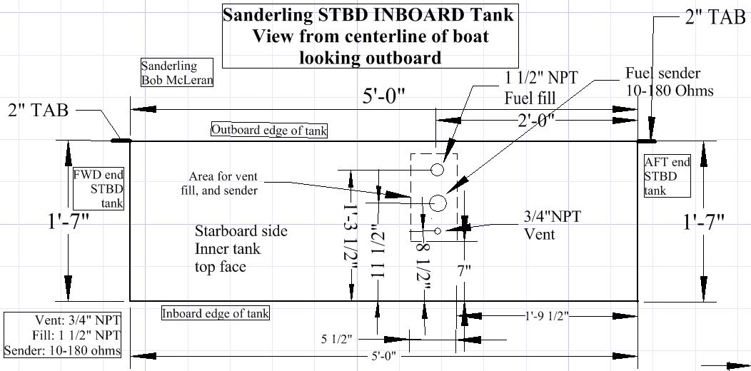
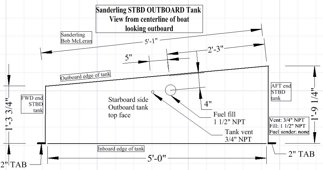
Here’s a link to the PDF file which you can download and use for some initial calculations:

Wind load tables and prop thrust

You will find a lot of helpful information at this blog by a very experienced cruiser:

Anchor Rode – Calculations by Jim Healy

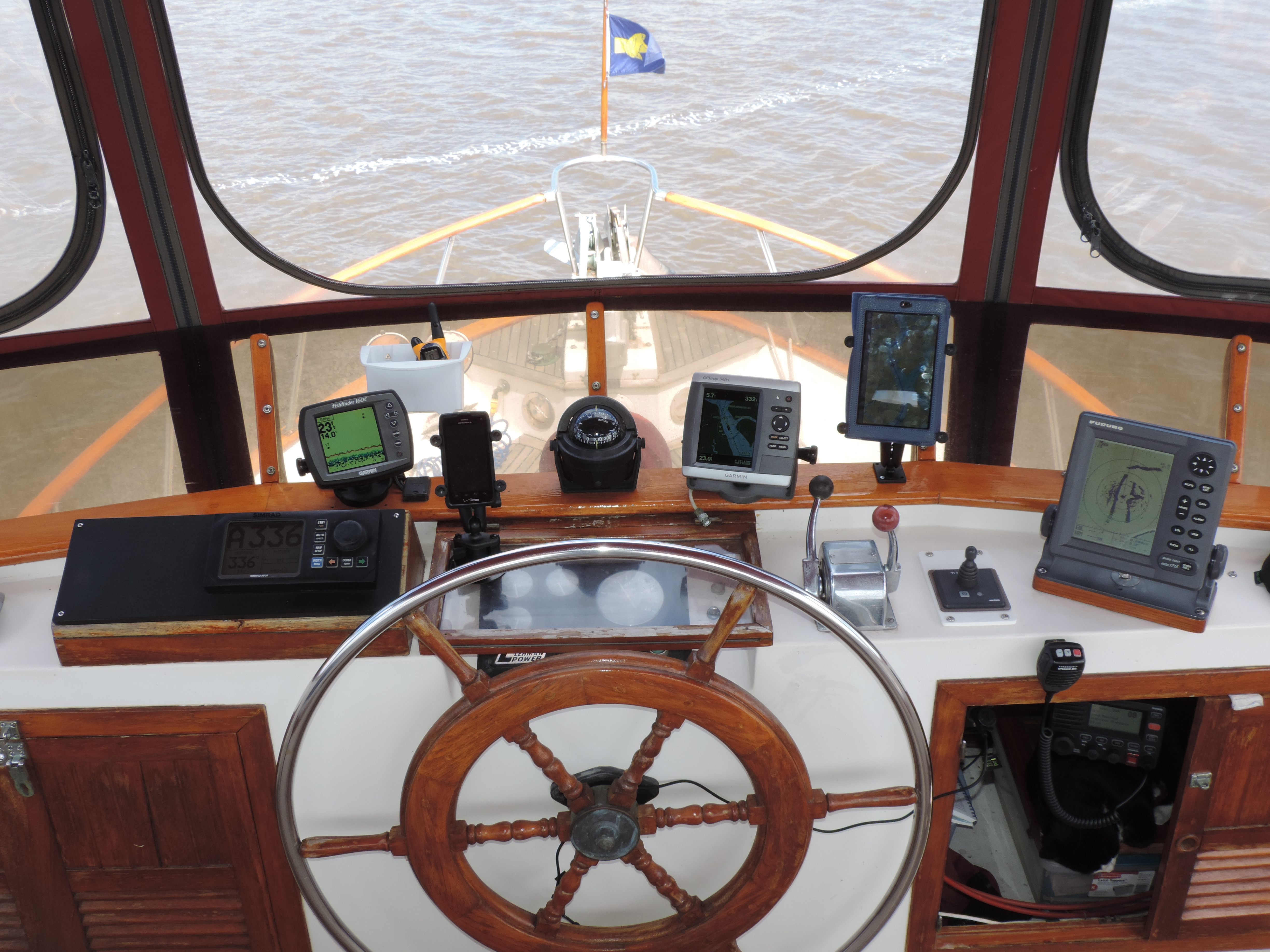
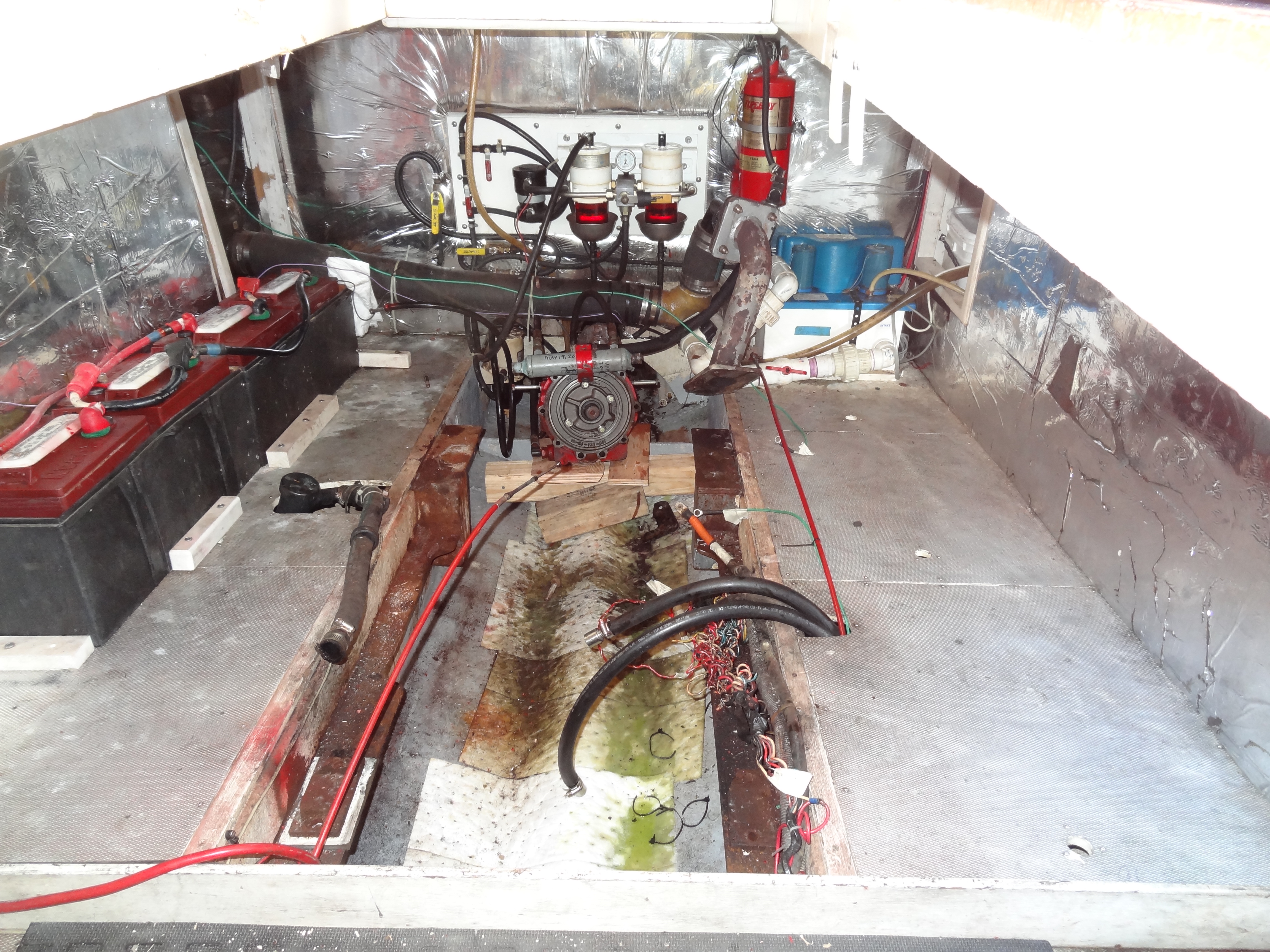
The more I thought about this topic, the more I realized that there’s little I can contribute to what was originally posted by a gentleman-boater named Captn Wil (Andrews) on the fore-runner of the Trawlers-and-Trawlering List in 1998. Captn Wil operated a Krogen 42 out of Oriental, North Carolina, for a number of years. His experiences (and tests) with anchors of various kinds and with actually anchoring in the waters of North Carolina and Chesapeake Bay resulted in a series of posts that are still highly regarded as THE definitive non-commercial “treatise” on anchoring. He also, BTW, is well known for his fuel filtration studies and the system he designed for onboard fuel polishing (see, Captn Wil’s Fuel Polishing System) .

Here in six installments are Captn Wil’s thoughts about anchoring.

Installment 101

Tue, 20 Jan 1998 21:59:54 -0500

1. Anchoring Introduction

1.1. This section will try to introduce some terms, definitions, and stuff which will be used throughout these presentations. I’ll define them here so we won’t need to take time and space to define them as they are used later. You may want to save them for reference later on.

1.2. In my technical writings I like to use text formatting and diagrams to make things easier to understand. I really do believe that a picture is worth a thousand words. Unfortunately, I hear from users that text formatting does not always get received well by all browsers. I’ll try to simulate text formatting with what’s available in normal ASCII characters.

1.3. I don’t know how to attach a vector drawing (or any other graphics) to E-Mail. If someone knows how to do that, I’ll try to include diagrams of some of the points as we go along.

1.4. I’ll try to number things so that identifying them for discussion will be easy. I’ll just make up a numbering system for this strange E-Mail format as we go along. As you can see, I’ve started this system. The first number will be the Article number followed by Subject, etc. Hope it will be clear as we proceed.

******************************

1.5 Definitions

1.5.1 Anchor System : All of the equipment which holds the boat to the bottom. It is made up of Anchor, Anchor Rode, Boat, Attachment points, and Bottom.

1.5.2 Scope: (The distance from the Anchor attachment point on the boat along the anchor rode line to the anchor) divided by (The vertical distance from the Anchor attachment point to the Anchor). Note with care that the vertical distance goes from the attachment point on the boat to the anchor. This distance must include the depth of penetration of the anchor, not just the depth of the water. In a right triangle with the anchor being the point of perspective, scope is the hypotenuse / opposite side. (What a wonderful place for a diagram)

1.5.3 Rode: All of the stuff which attaches the anchor to the boat.

1.5.4 Anchor Parts: Consider a Danforth Type anchor for these definitions:

Fluke : The sharp part(s) that hopefully sticks into the bottom.

Shank: The long skinny part that runs from the Rode to the flukes.

Stock: The part which runs perpendicular to the flukes. It is that round piece which tries to keep the anchor horizontal.

Crown: The two little flat pieces between the flukes – often inclined toward the shank.

Of course all anchors don’t have all those parts.

*************************

1.6 Mathematical Notation: We are not able to show all normal mathematical symbols with the standard ASCII codes , so programmers have come up with some shorthand for some of the standard symbols. Here are the ones we’ll be using.

A * B means A times B.

A^B means A raised to the Power of B.

The other symbols will be as you would expect

**********************************

1.7 By What Authority

I’ll present direct information gathered from repeatable tests I have conducted.

Conclusions drawn from those tests.

Information from tests by others.

A few equations from technical works and physics

And a few opinions of my own. I’ll make sure you know which are facts and which are opinions.

**********************************

1.8 Before We Start

I’ve tested anchors on purpose in mud and by accident in sand and clay. I know something about anchors in those bottoms. I have not tested anchors in coral, weeds, rock, etc. I  don’t have facts about anchor performance in those bottoms. My opinions about anchoring in these latter bottom would just be speculation, therefor, I’ll not give opinions about them.

**********************************

1.9 CaptnWil Laws

Just to get things started, I’ll end this first epistle with CaptnWil’s First Law. The next edition will cover some topics which will improve the holding capacity of any anchoring system in any situation.

Unlike natural laws which cannot be disputed, on some rare occasions (generally after a few drinks), some have disputed some of CaptnWil’s Laws, but you can be assured that CaptnWil’s Laws are based on natural laws of physics, geometry, etc.

1.10 CaptnWil Law No 1. : USE ENOUGH ANCHOR

You should notice right off the bat that ANCHOR is singular and not plural. Note this well. In any situation where two anchors are set on two rodes, ALL THE LOAD WILL BE ON ONE ANCHOR ALMOST ALL OF THE TIME This is a physical fact, but we don’t even need to present the mathematical proof because you can prove it for yourself right now. Get a small diameter line about six feet long. Tie a small loop in the middle of the line. Consider that the loop is where two rodes are attached to your boat. Tie each of the ends of the line to opposite ends of a yardstick. Lay this whole business on the floor. Keep the yardstick in a fixed position. Put your finger in the loop, pretending you are the boat, and pull back so both lines are tight. Move the small loop left and right. You will notice that there is only one place where BOTH LINES ARE TIGHT. Unless you can keep your boat in one spot, ALL  THE LOAD COMES ON ONE LINE ALMOST ALL OF THE TIME. Multiple anchor sets have some uses, but increasing your anchoring capacity is not one of them. That means that you cannot rely on using two “normal anchors” to increase your anchor capacity for storm protection. The safety of your boat relies on the capacity of ONE ANCHOR. Ain’t fair, is it? At least one post indicates that this fact is not unknown to all — thank God — but for those who didn’t know this fact, consider it well.

In closing this session, let me emphasize that the only anchor which can secure your boat must be attached to your boat and stuck in the bottom. It does no good in your anchor  locker.

CaptnWil
AfterSail
New Bern NC

Anchoring 201

Thu, 22 Jan 1998 09:34:06 -0500

2.1 First MistakeMy friends have heard CaptnWil say, “This is the first mistake I’ve ever made” a lot. You’ve heard it for the first time, but likely not the last. This whole thing should be titled, “Anchoring”, not “Anchors.” Anchors are but one part of anchoring and we’re trying to cover the whole subject.

2.2 CaptnWil’s Second Law

You must Answer What Questions before you can Answer How Questions.

Using some formal procedures developed in the computer programming field can help us get to the answers in a most efficient manner. Those general procedures are called, “Top Down Design, and Step Wise Refinement.” That means, start with the most general part of the problem 96 at the top 96 and proceed down to the most detailed part of the problem, refining each step along the way — then go back and refine each step as needed..

In this case the first “What” is, “What must I do to keep my boat attached to one spot on the bottom?”

The Top Down Design starts here by stating the first “How.” Attach an anchor rode to the boat on one end and an anchor on the other end with the anchor stuck into the bottom. From this general statement We’ll develop some detailed information and data to help solve the whole problem.

2.3 Loads

When the wind blows, the current runs, and the waves come up, loads are transmitted to the anchoring system. If any part of the anchoring system fails, the entire system fails. Our solution must include each part of the system. Some are pretty obvious. Some have been obscure. We’ll try to look at them all.20

2.4 Penetration

Except in situations which cannot be described as “anchoring”, penetration of the bottom by the anchor is the single overriding issue in all anchoring problems. While at the moment, this may seem obvious, you’ll discover that most of us in many sad situations have ignored it. Remember, Penetration! Penetration! Penetration!

This is so important that while the following is not quite a CaptnWil Law, it is a CaptnWil Saying.

With proper penetration, most any anchor will hold your boat. Without proper penetration, no anchor will hold your boat.

You did get the emphasis on the word, “proper.”

2.5 The Bottom

Our next most important issue is the bottom. The holding capacity of any anchoring system is limited by the physical makeup of the bottom in which we stick our anchor. This is the part most people overlook. The whole anchoring solution involves the engineering disciplines of Soil Mechanics, Mechanical Engineering, and some stuff from Aeronautical Engineering.

The load applied by the anchor. Unless the bottom can take the load, it doesn’t make any difference how strong the anchor is or how big it is. As an extreme example, you can hang the worlds largest anchor in air and the air won’t have enough resistance to hold your boat.

2.6 The Rode

The performance of our system is greatly affected by the rode we connect to boat and anchor. As we go along, you may be surprised about some of the unusual ways the rode affects the anchoring system. It did me.

2.7 The Anchor

Mercy, the anchor is the last item the fool mentioned. While its importance cannot be over stated, it should be considered only after the basics described above have been investigated. After that investigation, the selection of the particular anchor will be a very simple matter. You just need to find some idiot to go out and test anchors under the conditions you expect or go test them yourself.

2.8 Where to Start

We need to start by trying to determine just what loads will be put on our anchoring system. I first found the most common formula used for this purpose in a little publication by Rule Industries written by Mr. Robert Danforth Ogg of Danforth fame. I later was advised that it is the formula used by the US Navy.

In addition, it is helpful to know just what force your own boat can exert. This information helps you make a good judgement about how good your anchor will hold. I consider the information in “Propeller Handbook” by Dave Gerr to be invaluable to any boater and especially to Trawler folk. Mr Gerr has provided a formula to compute the pounds of thrust of your propeller.

To make things easier, I long ago expanded these two equations into tables. Since that time, these tables have been used by my friends and me in finding solutions to serious anchoring questions. Questions like Hurricane Protection.

[I’ve created a spreadsheet in PDF format with WIND LOAD TABLES and MAXIMUM THRUST PROVIDED BY BOAT PROPELLERS which is easier to read than the tables Captn Wil included in his emails. Here’s the link (also at the beginning of this page). Wind load tables and prop thrust. ]

I hope you can at least read them and figure out where the columns go. If you copy the tables into a text editor with RTF capabilities, you can make the format acceptable. To help you format the stuff, I offer the following.

In the first two tables — the Wind Force Tables — The first column is the Square Feet of that part of the boat exposed to the wind. The top Row is the wind velocity in knots, and each of the other entries are pounds of pressure exerted on the boat.

In the Propeller table: The Shaft Horse Power is the first column. The top Row is the propeller diameter, and each other entry is the maximum pounds of thrust to the water.

**********************************************

Now that we have most of the basics down, we’ll get into the meat of the subject next time.

CaptnWil

AfterSail

New Bern NC

Anchoring 301

Mon, 26 Jan 1998 21:01:51 -0500

3.0 War Stories

Evelyn (my wife) had almost divorced me (well, she didn’t speak to me for a very long time) when I sold our 45-ft. Bristol sailboat and started looking for a Trawler. She had suffered during the delivery voyage from Miami through eight guests on a new (to us) boat, engine over-heating, and engine stopping due to clogged fuel filters. We survived it all and on the last day out before berthing in Mitchell Creek, we dropped anchor in tranquil Cedar Creek, just off Adams Creek on the ICW in North Carolina.

As a sailboat captain, I knew how to anchor. I had read all the Danforth stuff, and all of Chapman’s stuff. From Danforth, I knew that you put six feet of chain between the nylon rode and anchor, lower the anchor hand over hand to the bottom and slowly back away. When you increased the RPM and the anchor held, you knew you were set for the duration. I knew it worked because I had done it many hundreds of times. For the new Trawler, I had spent a lot of money for a Danforth Deepset anchor. The Trawler came with a CQR, 200 ft. of chain rode and 200 ft. of nylon rode. I really had a good anchoring  system.

On this delightful North Carolina late afternoon in May, I lowered the Deepset to the bottom, looking forward to the Scotch and Soda on the marvelous aft-deck. Evelyn was preparing the drinks as I eased the transmission into reverse to back down on the anchor. I would only increase the RPM when the nylon rode came tight Just as a safety precaution, I asked Evelyn to keep a lookout over the stern.

If you don’t know what female screams about crab pots! — “STOP!” — “you’re going aground!” — “what are you doing!?”, you haven’t spent much time as Captain with a wife as a First Mate? If you have, you know exactly what was going on. The Damned anchor would not set — the anchor rode would not come tight we were going toward shore and aground with alarming speed.

Not to worry. “Evelyn, if you’ll just hold the wheel, I’ll retrieve the Danforth and set the CQR.” It was not all the mess from the black gunk that got all over everything when I retrieved the Danforth that was so bad, it was the paper towels and commands of not to get that mess in the pilot house that made this such a trial. But the CQR would keep the Scotch and Sodas safe and available in short order. This time I’d use the all chain rode and guarantee the anchor would set.

After another bout with paper towels, mud, etc, the CQR was overboard and we were moving astern to set it. You must believe that female screams will get your attention. I really believe they are the substance civilization is made of. With the screams, I stopped the boat thought about it decided to leave things as they were. After all, the winds were light and predicted to stay light the ice in the scotch and sodas was melting, and I couldn’t abide anymore screams. To be sure the anchor would “soak in.”

If this were a true soap opera, I’d now tell you about storms and high winds, but the winds did not come up, and we slept the sleep of the exhausted. I retrieved the chain and CQR next morning and wondered to myself why neither anchor had PENETRATED the bottom and set.

Later with the hurricane season fast approaching, I set out to survey my new “hurricane hole,” Mitchell Creek. The water measured a little over five feet. I deployed two anchors set at 45 degrees off the port and starboard sides of the bow. I slowly payed out 300 feet of rode (scope of 60) and then put the transmission in reverse. I waited for the line to come tight, and waited. I had sense enough this time not to wait for screams of crab post and things. I took a deep breath, swallowed hard, and realized that after all these years, I didn’t know a damned thing about anchoring. That was not so scary, what was scary was that I had done it all by the book. Didn’t anyone know anything about anchoring? That was the day I became an anchor tester. I tested every anchor I could beg, borrow, or steal in Mitchell Creek. I tested Danforths, Bruces, CQRs, and Northhills. Nothing would PENETRATE the bottom in Mitchell Creek. Why??? Well, Dummy, inspect the bottom and find out why. I found out that I could push a ten ft. piece of PVC pipe out of sight by hand into the bottom of Mitchell Creek. It was soft, oozy, black, mud.

3.1 Beginning To See The Light

Were all those anchors worthless? Had those manufacturers lied to me? Some of them rated their anchors at more than 1000 lbs. of pull. All of them said that the anchor I had tried was satisfactory for my 42 ft. Kadey Krogen. And then the light dawned. They didn’t say anything about what kind of bottom was necessary for their anchors to work. They didn’t say anything about the bottom. They talked about rode and anchor and scope and chain. Gentle reader, I remind you again, PENETRATION! PENETRATION! PENETRATION!

This is a biggie. Mark it in red.

HOW FAR MUST THE ANCHOR PENETRATE?

The anchor must penetrate until it finds material with enough integrity to hold the load applied to it by the anchor. How far is that? In good hard sand, it may be six inches. In Mitchell Creek, it is TEN FEET! In San Francisco Bay, it may be TWENTY FEET.

How can I tell if my anchor penetrated far enough? Test it.

3.2 Test It

Find those tables that were so hard to distribute over the Internet for the next part of this discussion.

A sailboat captain may have an excuse for his anchor dragging, but a trawler captain does not. First of all consider a sailboat with a 30 hp engine which has a 12-inch propeller. Consider that the boat has 125 sq. ft. exposed to the wind. From the thrust table you will see that in forward gear the maximum thrust he could get would be 612 pounds. In reverse he might get 300 pounds. Look at the “Load on Boats Due To Winds” table using a Cd of 0.70 and find that the load on his boat is 267 pounds at 30 knots. When he backs down on his anchor to full RPM, he can’t put much more pressure on the anchor than a 30 knot wind. It should be no secret why sailboats regularly start to drag anchor at 25 knots.

My Krogen 42 has a 28-inch propeller with a 135-hp engine. From the table, in forward gear I can get about 2580 pounds of thrust and a strain gauge verifies the table to be accurate. I also get most of that in reverse. Consider that my exposed surface to the wind is something like 200 sq. ft. Using the wind table with a Cd of 1.0 you can see that I can test my anchor for a wind in excess of 60 knots. Since I have a means for such a test, I can have no excuse for my anchor dragging.

IF YOU CAN MOVE YOUR ANCHOR WITH YOUR TRAWLER, YOUR ANCHOR DID NOT PENETRATE TO SAFE BOTTOM.

If you make that test on every anchor set, you will get some big surprises. You’ll also learn a lot about the bottom. Most of the time, you’ll also be horrified about how little your anchor penetrated.

All of this means that for any anchors we are likely to carry on our boats, there is a limited range of bottom conditions where the anchors will penetrate. While not described above, a very hard bottom — rock, coral, etc. — is at one end of the scale. Soft mud is at the other end.

We’ll look at our options to increase our chance of penetrating the bottom next time.

CaptnWil
AfterSail
New Bern NC
Anchoring 401

Tue, 3 Feb 1998 21:52:53 -0500

In this session we’ll get so close to the fire that you will be in danger of getting burned. This session will reveal some of the things I learned from others and confirmed by my own tests as well as things learned from the tests alone. I feel sure that you already know some of them, but I suspect that some will surprise you as much as they surprised me.

4.1 Bottoms

I discovered that a great majority of the places I want to anchor have a mud bottom. This is especially true of storm anchorages. Upon reflection, this should not have been a surprise. After all, when we want to have a quiet anchorage or a storm protected anchorage, we go up creeks, into protected coves, and other places where wind and current are minimum. When current slows down, the solids settle to the bottom and over eons of time becomes thick silt. This is no mystery, that’s how deltas and bars are made.

This IS especially true of the east coast of the US from Chesapeake Bay to the South Carolina border. It is almost a law in the sounds of North Carolina which have no lunar tides – only wind tides. But this situation in not limited to these areas. It is true anywhere current slows down.

As prevalent as this condition is, it is not a condition which can be assumed. Parts of the south shore of Albermarle Sound and Alligator River in North Carolina have some of the hardest sand and clay bottoms I have ever seen.

My belated discovery came because of the terrible time I was having trying to make anchors hold. I was having a few problems in open water, but it was just impossible where the damned mud was. The problem was that mud was in every hurricane hole I found.

My, only if it would hold in mud, and I couldn’t make a single anchor do that. In addition, I was having a hard time setting the Deep Set anchor anywhere. It was in the pursuit of trying to set the Deep Set that I got the first help in anchoring in mud.

4.2 Heresy

I called Max Schultz, the chief engineer for Rule Industries and complained that I couldn’t set his Deep Set Anchor. Take a deep breath! Get a drink! You won’t believe what he said.

Max: REMOVE THE CHAIN FROM THE ANCHOR RODE!

CaptnWil: Do What?

Max: REMOVE THE CHAIN FROM THE ANCHOR RODE!

CaptnWil: You’re crazy!

Max: If you don’t want to set the anchor, forget it!

I didn’t believe him then, but I tried it. Guess what? He was right. Since that time I have made many tests with many different anchors. All of the anchors I have tested set better without ANY CHAIN. That is important, but remember, its not just setting we’re after, we are after PENETRATION. The most important part is this:

ANY ANCHOR WILL PENETRATE BETTER WITHOUT CHAIN

There’s a bit more before you go out and try it. The chain does prevent the bottom from eating away your nylon rode. I know because I anchored for two days with nothing but nylon rode. The Deep Set held fine, but the end of the rode looked like rats had been at it for the whole time. What then goes between anchor and nylon rode?

4.3 Cable goes between the anchor and rode.

I don’t really know why the chain hinders an anchor from penetrating, but I suspect it has to do with all the stuff it picks up as it moves along the bottom. If you have ever anchored in mud, you know how filthy the chain is when you retrieve it. Cable, on the other hand, comes up clean. The cable offers even less resistance to the anchor penetrating than does the nylon rode. If your anchor will penetrate at all, it will do it better with cable.

There is a down side to cable. It will kill you if you try to handle it under load. You must not try to handle it when you retrieve the anchor. The solution is to attach a line of comfortable size (3/8 to 1/2″) along side of the cable about three-feet longer than the cable and attached to the nylon rode on one end and the anchor attachment on the other. When you bring the cable aboard, handle the line instead of the cable.

Cable will not solve all your anchoring problems, but it will increase the efficiency of any anchor you use.

4.4 Increasing Anchor Capacity

Under actual conditions, the most serious loads are shock loads, and these can cause your anchoring system to fail. The other side of the coin is that removing the shock loads can increase the capacity of your system.

When I make presentations in person, I demonstrate the effect of a shock absorber by the use of a hand-scale, hammer, nylon line, and rubber bands. I attach a hammer to the scale by a three foot nylon line. I then drop the hammer the three feet and read the pounds on the scale. The scale reads twenty. Next I attach the hammer to three feet of rubber bands attached to the scale. When the hammer is now dropped, the scale reads two pounds. In addition, the rubber bands have stretched to about six feet before returning to their original length. The result is obvious, the peak load is reduced. Note that the total work remained the same, it just took longer which put less load on your anchor. Now how do you get rubber bands into your anchor rode? I haven’t found out how you can put rubber bands into an anchoring system, but you can put a shock absorber into the system.

Good new nylon line will stretch about 20% under its design load and return to its original length when the load is withdrawn. That means that a 100-ft. line will stretch 20 ft. under its design load. That much movement provides a lot of shock absorbing. The problem is that the shock load comes long before your normal anchor rode has stretched very far at all. After all, you have selected your anchor rode to be strong enough under the most extreme conditions. You even size it a little bigger to be safe. You need to have a line which will stretch before much load is applied, but will be strong enough to take all the load. Here’s what to do:

1. For nylon rodes, always use three-strand nylon instead of braided nylon. The three-strand has the better stretch characteristics.

2. If you use chain rode, use the shock absorber described in (3) below.

3. Install a shock absorber beside your main rode. If your main rode is 5/8-inch nylon, lay a 3/8-inch nylon line beside it 10-percent shorter than your main anchor rode. This system should be considered anytime severe weather is expected. It can save your boat. I have used this method in my hurricane anchoring set-up. For that service, I use a one-inch nylon main rode with a ╜-inch shock absorber. When the winds blew 50 knots, the one-inch rode never came tight, it just got almost straight.

4. Never use chain alone in severe conditions. In the water depths in which we anchor, it is a bad myth that the chain gives any shock absorbing at all. To prove this, just let out 100 feet of chain in ten feet of water – set the anchor – go forward on it ten feet – then reverse the transmission and let the boat come up tight against the chain. I used to clear stumps this way with a jeep in my youth. I also broke a chip out of my chain stopper when Evelyn didn’t get the transmission out of gear before the chain came tight – but that’s another story I can’t tell you.

*******************************

That’s enough fire for this time. Next time we’ll get into some specific

anchor tests. I’ll give places and name names. Only the fittest survive!

CaptnWil
AfterSail
New Bern NC
Trawler World List: Anchoring 4.01 and a half

Anchoring 4.01 and a half

Thu, 5 Feb 1998 18:01:30 -0500

I knew the cable issue would give all pause. Let me go back to the beginning. I’m an anchor tester. I also have an engineering background. I’ve made all the conclusions about what crowns and flukes and chain and stuff does to the anchor, BUT THE FINAL WORD is how did it test? I just put the dog on the track and watch him run.

I cannot generate any test data to demonstrate that weight of any kind, including chain, at the end of the shank of a Danforth, or any other anchor helps it penetrate. All of my tests demonstrate that anything on the end of the shank make the penetration job harder for the anchor. The lesson is that the less you can put there, the better. The cable offers the least resistance to penetration than any item I have found. That does not mean that something better is not available – I just haven’t found it. I’m sure that chain doesn’t help.

We’ll get to Fortresses and MAXes and Danforths in some detail in 501, but for now consider that Danforth has always advised putting six-feet of chain between the anchor and rode. It was when the chain was removed from the deep-set anchor that it would set at all. I had tried six-feet, twenty-feet, and fifty-feet. The only purpose Danforth ever had for the chain was to prevent chafe – and it will do that.

Most of the time I am able to make some engineering sense out of the results of the tests I run. I must confess that this chain, cable, penetration thing defies explanation. I just know what happens.

CaptnWil
AfterSail
New Bern NC
Trawler World List: Anchoring 501

Anchoring 501

Fri, 6 Feb 1998 09:58:12 -0500

5.1 At The Beginning

Anchors and Women have many similar characteristics. If you handle them properly they’ll serve you well and save your life. Handle them poorly and they will dump you and never look back as you slowly fade away.

Each anchor has a set of characteristics which are unique to it. One of the most important things an anchor tester can do is take the time to learn what the anchor wants. It is even more important for the captain who trusts his boat and the lives of his crew and passengers to the success of the anchor to know every detail about what the anchor needs to perform at its best.

I find that most of the tests I read about and which I observe fail on this score. The testers just throw the anchors out and try to come to a definitive judgement about the performance of the anchor. In all of the tests I do, I test one anchor at the time. I test it many times. It is seldom that I can conclude a test on a single anchor in one week. It takes me that long to get to know the anchor well – it’s kinda like the courtship of a beautiful lady. I want every anchor to be great. I want to give it every chance I can. I want to have confidence in what I say about the anchor.

5.2 Hard Lesson Learned

Most everything in the boating world is measured by ratios. Hull speed is 1.35 times the square root of the waterline length – the cost of a yacht goes up as the cube of the length – and on and on. Most of us have made the mistake of believing that anchors also follow ratios – big boat, big anchor – little boat, little anchor. It is a true generalization that a smaller boat requires less holding power than a larger boat, but that does not transmit directly to the size of the anchor.

Many anchor manufacturers have gone on the assumption that the anchor performance would be proportional to the proportional size change of the anchor. Anchor users have accepted this premise without question, and in many cases to our ruin.

Here’s the awful, ugly truth. The bottom does not obey the law of ratios. If it’s ten feet to good holding bottom for a 60-foot boat, it’s ten feet to good holding bottom for a 30-foot boat. Both boats must get their anchor to good holding or they will drag. It took me a very long time to discover this very elementary fact.

It does not matter how the anchor penetrates to good bottom, it’s just necessary that it does. The anchor weighing 30,000-pounds on an aircraft carrier penetrates to good bottom by its sheer weight. Most anchors on pleasure craft of the size we have penetrate by being pulled to good bottom by their shape and proportion. The weight is just what is necessary to make the thing. You can believe that the 30,000-pound anchor weights less in proportion to the weight of the air craft carrier than the weight of the 45-pound CQR does to your 42-foot trawler. The term “Light Weight Anchor” is just another illustration of the ratio thing. It’s a term defined in relation to what a man can pick up, not anything about the ratio of its weight to the weight of the boat.

The issue here is that if the anchor penetrates by weight, changing its weight will not affect its performance so long as the weight is not reduced below the amount necessary to allow the anchor to penetrate. That’s the major reason that anchors know as “Navy Anchors” do well on large ships, but poorly on yachts. They’re made big enough and heavy enough when deployed on ships to penetrate to good bottom.

On the other-hand, changing anything on an anchor which penetrates by shape and proportion can, and often does, change the performance of the anchor completely. It is unsafe and unwise to extrapolate results from these kinds of anchors. The is especially true when the anchor size in question is sufficient to cause the anchor to penetrate. Trying to extrapolate those results to an anchor of the same shape, but whose weight is not enough to cause the anchor to penetrate is a constant concern. The results described below are for the particular size or weight anchor used in the test. Different results might be obtained with different sizes of the same anchors. Whenever you see figures of load capacity quoted by an anchor manufacturer, ask that manufacturer if each anchor size was tested to arrive at the quoted figures, or if the figures are ratios based on testing only one anchor.

5.3 Bottoms

The anchor sticks in the Bottom and the Bottom must accept all loads transferred to it by the anchor.

1. Good Bottom

Good bottom can be penetrated by the anchor with little effort and has enough structural integrity to hold the load transferred by the anchor. The amount of penetration required for structural integrity is not great. It is what we all look for. The anchor goes in easy, comes out easy, and is clean when it comes up.

2. Soft Bottom

For our purposes, soft bottom is a very special kind. It is generally referred to as “mud”, but that doesn’t really describe it. A more descriptive term might be “Silt.”

The characteristics of this bottom are produced by solids dropping out of solution with the water as moving water slows down. This water originally came from some far away place, maybe even the mountains. Long ago in its journey, the big stuff (rocks, gravel, etc.) have already settled out. Now all that is left is very fine, generally black, matter. This stuff has been deposited at this one spot for as long as conditions have remained the same. It may have been doing this routine since God made this body of water. You’ll get a depth sounder reading far above any solid material in the bottom.

The important thing about this bottom is that this silt has absolutely no structural integrity at all. In our Mitchell Creek, this layer is ten-feet deep.

3. Hard Bottom

Bottom which is so hard that it is difficult to get an anchor to penetrate it at all. The obvious examples of this bottom are, rock and, coral. Very hard sand and clay can also fall into this category.

4. Other Bottoms

I lump everything else into this category because I don’t have any test results in them. They include grass and kelp. One of the toughest “Other” bottoms I have encountered is the leaf covered bottom in Washington DC.

5.3 Anchor Types

I break anchor types into two classes, (1) fixed, and (2) adjustable.

1. Fixed

Except for one anchor I’ll surprise you with later, until about 1990, all of the anchors we could use on our yachts were of the fixed type. Those that I have tested include, Danforth Standard, Danforth Hi- Tensile, Danforth Deep Set, Danforth Soft Bottom, Danforth Plow, CQR, Bruce, Northhill.

All of these anchors are effective in one kind of bottom. All except the Danforth Soft Bottom are effective in “Good Bottoms.” They will not penetrate deeply in “Soft Bottoms’, and are difficult to set in “Hard Bottoms.” The characteristics of these anchors is why I went on my anchor search and anchor tests.

My tests indicate that each of these anchors have their individual characteristics, strengths, and weaknesses in “Good Bottoms.” I’ll list a few.

Bruce

Good:

This is the fastest setting anchor I have used in the fixed anchors. It doesn’t much care how you deploy it – you can just chunk it over the side. I used it for a long time as an emergency anchor for stopping the boat upon engine failure at bridge openings, etc.

While it doesn’t penetrate very far, it resists pulling out when the direction of the pull changes.

It is not finicky about scope.

Bad

It has the least holding capacity for its weight of all the anchors I have tested.

When it is overloaded and drags, it tends to bury the rode end of the shank and pull the claw out of the ground. When it drags, the claw is most often filled with bottom material and the anchor will not reset.

My test were made with the 44-pound anchor. Increasing the size and therefore the weight could make this anchor penetrate better. It is said that this was developed to anchor the oil well platforms in the North Sea. Those anchors weighed tons instead of pounds. I have no doubt that in the sizes first designed, they penetrated deeply and held their design loads very will. Its characteristics in small sizes demonstrate the dangers of reducing the physical size and using a ratio to assume its holding capacity in the smaller size. I have seem a very large Bruce, maybe 500 pounds, on a very large yacht (100 + feet). Of course I haven’t tested that monster, but I’d bet it would do well in that size.

CQR, Danforth Plow

Also called “The Plow.” For you City Slickers, it should be called a “Double Bottom Plow.” In good bottom, when properly set, this is an exceptional anchor. This anchor must be set very carefully and a very large scope used. Its great worth is that most of the time its capacity is the same after it drags as before. It does just what it’s called, it “Plows.” Almost all other anchors have little or no holding capacity once they drag.

I feel strongly that the great reputation of this anchor comes from its ability to retain capacity after it drags. I suspect that the use of long lengths of chain came into play because of this anchor, trying to satisfy its very finicky setting requirements. This was just one means of trying to overcome the problem with setting.

As indicated above, this anchor does not break out often, and that can fool you about how well the anchor has penetrated. If you don’t back down on this anchor hard – full RPM – you may think it is secure when it isn’t. I had a frightful experience with this in the Keys. Using a scope of ten, it took me ten tries to get the anchor to hold at 1500 RPM. It would hold at below that RPM every time, but would start to slowly plow its way across the harbor at 1500 RPM. Made for an uneasy night.

The two plow anchors I tested were a 45-pound CQR and a P-1900 Danforth. The Danforth outperformed the CQR because it had larger flukes (plow) than the CQR.

I spent about three hours trying to set two of these anchors in “Hard Bottom” on the ICW north of Beaufort SC. I finally found some good bottom, set the anchor, and survived a night of high winds. It was the same 45-pound CQR that wouldn’t set in “Soft Bottom” in Cedar Creek which started me on the anchor testing thing.

Danforths

Except for the Danforth Plow described above, all of the Danforths are similar in design and you know them very well. They do well in “Good Bottoms” and are better than most in “Hard Bottoms.” These characteristics should not be surprising because they were designed by Mr. Danforth in the late 30s to work in sand. Later they were deployed on landing crafts in WWII. Where do landing crafts need anchors? On SAND beaches. These anchors pulled the landing crafts off the beach after discharging their loads (men or material). They helped win the War and keep us free. I have a special place in my heart for the man who designed this anchor and the anchor that did the work.

The original Deep Set had a very small crown set at a very small angle. This seemed to contribute to its difficult setting characteristics. I have forgotten what size Deep Set I tested, but it was the largest I could buy. In fact, I bought two of the things for a lot of money. I notice that the new Deep Sets have conventional Danforth crowns.

I have found no difference in the Hi-Tensile and Standard versions in holding power or characteristics. I’m sure the strengths differ.

Danforth Soft Bottom

After my discussion with Max Schultz about the Deep Set problem, I called him about the “Mud” problem. He was kind enough to send me a prototype “Mud” anchor. It became known as the “Soft Bottom.” It was the first anchor I ever tried that would penetrate “Soft Bottom.” More about this anchor later. I don’t think it is made now.

Northhill

Once this anchor failed in “Soft Bottom”, I did not test it again. I hear that it is good in rocks – not rock.

5.4 Fixed Anchor Conclusions

It’s been some years since I tested any of those fixed type anchors because my first requirement of an anchor is that it hold in “Soft Bottom.” Those early test left me in despair. My main concern was how to save my boat in hurricanes and other storm conditions. I didn’t know what I was searching for, but knew I had to find a “Mud” anchor. Those results next time.

CaptnWil
AfterSail
New Bern NC
Trawler World List: Anchoring – 601

Anchoring – 601

Sat, 7 Feb 1998 23:28:05 -0500

6.1 The Yellow Brick Road

Much like Dorothy on the yellow brick road, the path in this anchoring mess was not straight. Facts came in bits and pieces – forward at times and backward often. I pursued every anchor manufacturer I could find a phone number for. I was sure I had hit pay-dirt when Max Schultz sent me his “mud anchor.” It held to full RPM in Mitchell Creek. This thing wasn’t so bad after all.

When I asked Max why the “mud anchor” worked, he explained very gently that Mr. Danforth had discovered by empirical means that the angle of the fluke needed to be thirty-two degrees to set and hold in sand. Later Rule Industries people had discovered by empirical means that the fluke angle needed to penetrate soft bottom was forty-five degrees. That is what set the “mud anchor” apart from the “sand anchor.” Mercy! This thing is simple. Use an anchor with forty-five degree flukes and no chain and you will be secure. New concepts, all problems solved. WRONG!

This is important! This is the whole story! For an anchor to hold:

THE ANGLE OF THE DANGLE IS INVERSELY PROPORTIONALLY TO THE DENSITY OF THE BOTTOM THE DANGLE IS STUCK IN!

I learned the sad truth that a Danforth style anchor with a fluke angle of forty-five degrees, which did just great in “Soft Bottom”, just bounced over the sand bottom of Alligator River. A 45-pound CQR, on the other hand, did just fine. The implication of all of this was that I needed to carry TWO SETS OF ANCHORS – one set for “Good Bottom” and one set for “Soft Bottom.” How much more despair was I in for?

6.2 Light At The End Of The Tunnel

No, it wasn’t the light of the train coming the other way. It was Dan Wolfe who runs Fortress Anchors.

CaptnWil: I want to talk to you about the capacity of your anchors in mud.

Dan: In mud our anchors have eleven percent of rated holding power in sand.

CaptnWil: You’re who I want to talk to. What are you doing about mud anchors?

Dan: We’re developing a “mud” anchor as we speak.

CaptnWil: I interested, can I test it?

Dan: Yes. By the way, we’ll have AN ADJUSTABLE ANCHOR SOON.

CaptnWil: I’ve discovered that chain doesn’t help.

Dan: Yes! Use CABLE. We’ll market it soon.

What a day! Fortress did go on to make an adjustable anchor, but never did market the cable. The day of the modern adjustable anchor was born. The Fortress can be adjusted for sand, etc. by setting the flukes at an angle of 32-degrees. It can be adjusted for “Soft Bottom” at 45-degrees. It has similar characteristics to a Danforth which isn’t surprising once you see its shape. There are material differences which I’ll discuss a little later on.

Dan and I arranged to test anchors together for some time, and for a while the Fortress was the only adjustable anchor available. It was also the only one which would penetrate “Soft Bottom.” Both with Dan and in tests I conducted alone, the effectiveness of the cable was demonstrated over and over.

A new member to the adjustable anchor group appeared a couple of years ago. This is the MAX manufactured by Creative Marine. It can be adjusted to three positions instead of two. It doesn’t look like anything you have ever seen before. It is an ugly brute and if you dare to put it on your bow-roller you must believe in it because its only redeeming quality must be how well it anchors.

6.3 Not Rocket Science

We’ll cover both of these anchors in some detail a little later, but first let me set this straight. Designing an anchor to penetrate “Soft Bottom” is no longer a mystery. An individual can make any Danforth anchor into a “Soft Bottom” anchor, and in fact, I have a friend who did just that instead of buying a $500.00 Fortress for hurricane protection. It worked so well that he almost didn’t get it up from the bottom.

If you want to modify a Danforth anchor to be a “Soft Bottom” anchor, just get a file and cut away at the bearing point which stops the fluke until the fluke angle to the shank is 45-degrees. Modifying other style anchors is not practical because of their construction.

6.4 We Didn’t Invent Intelligence

A while back, I commented on the “Modern Adjustable Anchor.” The first adjustable anchor is many hundreds of years old, and I just discovered it a couple of years ago. Some facts from history nagged at me about this anchoring problem. For centuries great and small sailing ships had not only navigated around the globe without aids to navigation, etc., but had anchored more or less successfully in all kinds of unknown bottoms. I could find no mention of general anchoring problems from the historical things I read.

Everyone knows that those anchors have had poor results on yachts in smaller sizes. In my travels, I couldn’t get those anchors off my mind. At the annoyance of Evelyn, I’d stop and measure everyone I found either by pacing or later by carrying a small tape (some kind of nut?). Most of them seemed to be about the same size – ten to twelve feet long with five to six-foot flukes.

You know how they look. The stock is at the very top. “Why is that?”, I ask. To keep it stable. “Yes, but it would be more stable down at the flukes,” I say. BUT THEN THE FLUKES COULD NOT ROTATE DOWN INTO THE BOTTOM! “You mean the softer the bottom, the deeper the anchor will PENETRATE?” Yes, dummy, otherwise it wouldn’t be adjustable and could be used in only one kind of bottom, which wouldn’t work since we sail all around the world

“But why does it rotate into the bottom?” Because the resistance of the bottom working on the angle of the fluke pushes it into the bottom when horizontal load is put on it.

“Why is it ten feet long?” Well, dummy, if it rotates 45 degrees into the bottom, the crown will be seven feet (and change) UNDER THE BOTTOM, and the flukes will be 10 ft. under the bottom. That’s enough penetration for any place we sail.

“Thank you, Teacher, but why don’t they work on my 40-ft. boat?” My, you are dumb. You shortened the shank to 3 feet. Don’t you know the anchor must penetrate the bottom just as far for your 40-ft. boat as for the 200-ft. ship? Sometimes I’m a slow learner.

6.5 Fortress

In tests, many different sized Fortresses have penetrated ten measured feet under the bottom. Fortress is one manufacturer who tests each anchor to get the ratings it advertises. My first real “Soft Bottom” test on this anchor took place in Club Foot Creek. Dan had disturbed me greatly when he said that you can’t really tell much about the test unless you can ultimately make the anchor drag. Well, so be it, I deployed a small FX-11. That means that if the anchor were made of steel, it would weigh 11 pounds. I deployed it carefully in the lull just before a blow. I backed down on it to full RPM, then the wind came up to about 25 knots and the strain gauge showed just under 2,000 pounds. This little anchor finally moved and I shut down just as the wind died.

This anchor had passed my first test, and I tested the size I would normally use on the AfterSail (FX-37) in every bottom I could find. When set in proper configuration (32 or 45-degree fluke angle) the anchor performs marvelously, but its like a woman, you must do it her way.

The anchor is made of aluminum and is very light. This makes it a marvel to handle. My FX-37 weights less than twenty pounds. While that is a very great characteristic, it also means that it will swim very easily in the water. If it swims, it won’t set. Here’s how to set it:

1. Stop the boat. Really stop it.

2. Pay out the rode hand over hand and set the crown of the anchor on the bottom gently.

3. Lay the anchor down and take all tension off the anchor rode while the boat slowly backs away until the scope on the rode is about two.

4. This is critical. Hold the rode firmly in your hand and snatch the rode toward you with vigor. Real hard, with real vigor. Do that until you feel the anchor trip into the bottom. You’ll know when that happens because of the resistance in your hand. If it never comes up tight against your jerk, take the anchor in, clean it off and try again.

5. Now let the boat back off until the scope is about 5. Secure the rode and back down hard. You will be securely set.

6. The anchor will tell you if you are in the right configuration. If the bottom is too hard for your setting, the anchor will just bounce across the bottom. You can see and feel this condition on the rode. If the bottom is too soft for your configuration, the anchor will drag before you can apply much pressure to it.

7. Uniquely as far as I know, Fortress is the only anchor manufacturer who provides “mud palms” with their anchor. These are two plates which bolt to the crown of the anchor increasing the crown size. Since the crown is what trips the anchor flukes into the bottom, these palms are intended to be an aid to setting the anchor in “Soft Bottom.” Be warned though, any crown at all is a necessary evil. The crown is a hindrance to the anchor penetrating after it is once set. What we’d really like is a big, “disappearing” crown. Make every effort to set the anchor without using the mud palms.

8. If the bottom is soft, you’ll have the devil of a time getting the anchor up unless you know how. This will be covered after the discussion on the MAX since both present the same kind of problem.

9. The Fortress can be stowed as is or disassembled for storage below. This feature allows you to take as large a storm anchor with you as you can pay for. Remember, use enough anchor.

10. One thing the Fortress is not. It is not an emergency stopping anchor. Remember you must lay it down and put no pressure on it at all until you get it started to penetrate the bottom. If you throw it out in an emergency underway, it’ll just swim beautifully behind you as you slam into the bridge.

6.6 MAX

The Bad News

The MAX is not only ugly, it does not stow easily except on a bow roller. And not any old bow roller at that. The anchor has a single, very long fluke that looks something akin to an old fashioned steam shovel hoe crossed with face of the Tim Woodman in the Wizard of Oz. If your bow roller isn’t long enough, the fluke will ruin the bow of your boat. You really can’t imagine what it looks like until you see it, and you probably won’t believe what you saw when you do.

1. The anchor is adjustable to three positions: hard, soft, very soft. Its performance is extraordinary in all but very hard bottoms. I could not set it at all on the south shore of Albemarle Sound. I did set the Fortress at this location.

2. It sets very quickly with no special attention as to deployment. It rivals the Bruce in how quickly it sets.

3. It sets on short scope. Once when my engine overheated in Rebellion Reach in Charleston Harbor, it set in 50 feet of water on a scope of two in an emergency anchoring situation. There was about a three-knot current. When the overheating problem had been solved, my Ideal windless would not pull the anchor out of the bottom.

4. When overloaded, it just seems to slowly move along still stuck into the bottom. Often you have a hard time determining that it is really moving. When this happens on the AfterSail, I know it is set in the wrong configuration because otherwise I can’t move it.

5. The adjustment from one position to the other is made by changing the position of a bolt in the two-part shank. This adjustment arrangement gives the shank a funny appearance, but I have not been able to damage it through some torture tests. You must loosen both bolts in the shank and take one completely out. Then rotate the shank to the desired location and reinstall the bolt and nut. (What a place for a diagram – well, on second thought, I probably couldn’t draw the thing anyway.)

The danger here is losing the bolt or nut. I insist that at least three spare sets be kept on board all the time. If you lose the bolt and/or nut, you’ll not have much of an anchor.

6. The anchor is heavy. The one I use on AfterSail weighs 55 pounds. The weight by itself is no problem if you have a power windless.

7. Due to the configuration of the shank and fluke, pushing the anchor off the roller and returning it to the roller needs to be practiced before actually using the anchor. You’ll find that there is just one way to do it. If you do it that way, it won’t be a problem: otherwise you’ll use a lot of foul language. The problem is that there is a quadrant sort of thing half-way up the shank where the position adjustment is made. That quadrant insists on getting stuck on the bow-roller unless you do it just right.

I have a friend who has sailed around much of the world who knows he is a better sailor than I am, and thinks he’s a better engineer. We took Chuck and his wife on our final test of the MAX in the Chesapeake. We were gone for about 10 days and when we started, Chuck had nothing but contempt for the MAX. He had manners enough not to be obvious about it, but I knew.

The purpose for going to the Chesapeake is that after an anchor passes the test in Mitchell Creek, the final exam is Fishing Bay. For those of you not familiar with the area, Fishing Bay is a cove in the Piankatank River. It has depths of about 20 feet with as difficult a bottom as I have ever explored. For years I didn’t know what the bottom was because I never got anything back on the anchor. Any anchor would seem to set, but under load the anchor would drag. I almost lost my first sailboat there.

Since the anchor and rode always came up clean there, I assumed that bottom was something hard. When I was finishing the tests on the Fortress, I finally put the anchor in “Soft Bottom” setting. It set with a thud. It was the strangest soft bottom I ever encountered.

Fast forward to the MAX test. Chuck insisted that he would handle the anchor while I handled the throttle. We put the anchor in the middle position, set it properly, and started to back down. At 1600 RPM it started to move. The rode would just kinda snake from side to side as we made stern-way. I called a halt, pulled the filthy thing back on board, changed to extra soft setting and after Evelyn let me back into the Pilot House, we backed away again. This time, 2600 RPM and black smoke out the stern. Nothing moved except the prop wash. The 5/8-inch nylon line shrunk to less than ╜-inch. Chuck called out, “Bar tight!” and a new MAX convert was made. One of those ugly monsters now rides on his bow.

One of the most useful characteristics of the MAX is that it will survey the bottom for you. It brings up layers of bottom which are still intact. From the MAX, I was able to tell that the bottom in Fishing Bay is about a foot of the most awful yellow soupy gunk you have ever seen. It stinks and sticks to everything something awful (just ask Evelyn). Below that is the most beautiful white sand laced with black loam and sprinkled with small sea shells you have ever seen. At that depth, it is a perfect example of “Good Bottom.”

6.7 What It All Means

1. Unless there are conditions beyond my control, I’ll always have adjustable anchors on the AfterSail. Because the useful range of adjustable anchors is so great, and the useful range of fixed anchors is so restricted, I exclude fixed anchors entirely.

6.8 If You Go To Adjustable Anchors

There are some things common to both the Fortress and MAX.

1. They will penetrate so far in “Soft Bottom” that your windless won’t pull them out of the bottom. You must know how to bump the anchor out of the bottom with the boat. Here’s how:

1.1 Take in the rode until it is straight down – 90 degrees.

1.2 Go forward on the engine till the anchor comes up or the boat stops.

1.3 If the boat stops, take in the line as the boat moves back.

1.4 When it is again at 90 degrees, go forward on the engine.

Repeat these steps enough and the anchor will come up.

2. If you use these anchors, you must either have or install a good wash-down system. They will come up with a lot of bottom material on them. I’ve brought up stumps, logs, rocks, oyster beds, and much other assorted gunk. You’ll want to get it off the anchor before you take it on board. The strongest wash-down stream you can get is not too much.

6.9 The Cable

It’s always the cable that stirs the pot. At first, everyone wants to know why it works better than chain. Those who have used it in storm conditions stop asking. I don’t know for sure, and I don’t expect to spend time finding out. I haven’t used chain on my nylon rode since 1990. Since the results have been so spectacular, I have no interest in pursuing the matter further. I understand those who raise questions about cable – I did so myself at first. All I can suggest is that you try it and make up your own mind.

I use 3/8-inch stainless-steel cable for working cable and 5/8-inch galvanized cable for hurricane protection. I use the stainless-steel cable only because it is clean and stays bright. I have the cable made up with a thimble on each end.

I know, I know. You want to know how long the cable should be. Think about this. If the load pulls the rode straight, the length of the rode under the bottom is the scope times the penetration. If you have a scope of five and your anchor penetrates five feet, you have TWENTY-FIVE of rode under the bottom. Scary, isn’t it? I think 20 or 25 feet is a good place to start for working cable. I use fifty feet for the storm cable.

6.10 In Conclusion

I’ve named some names and given opinions on some anchors in this series. You need to know that all of the tests were done for my own personal anchoring requirements. I don’t work for, or have any interest in, any anchor company or other commercial enterprise connected with this project, and I don’t want to sell you anything

It’s at about this time in a personal presentation that I open the discussion to questions and comments from the floor. In this case, let me now open this discussion to the List.

CaptnWil
AfterSail
New Bern NC