Underway and anchored

Mechanic finished installing a new water pump about 1145 this morning while we were at Gardner’s Basin in Atlantic City, and we were underway at 1315 for an anchorage across the inlet. We had to get a deli sandwich at Gilchrist’s (a local favorite) in celebration of the successful repair before departing.

The world looks better now that we’re anchored out with a working generator.

Only fly in the ointment now is the weather. The wind is going to keep us out of the ocean so we will have to stay in the New Jersey ICW for a few days while we work our way inside to Manasquan where we will have to go outside to Great Kills (Staten Island).

The Erie Canal is still closed because of high water from recent rain.

Waiting for genset repairs

The local engine company promised they’d have a tech here BEFORE Friday with the necessary parts to replace the non-functioning water pump on the generator, so we’re still waiting!

In the meantime, Judy is working and Bob is messing around with boats. Last night we met Ralph and Celeste Yost (who also own a DeFever 41) after dinner; Bob and Ralph have bee email buddies for three years or so and finally got to meet in the flesh.

Bob also did some sight-seeing at the aquarium this morning. Some nice displays for a very small operation, but the school kids who visit every day really enjoy some of the hands on exhibits. Here’s a view of some of the casinos and marinas from the aquarium’s roof (that’s Sanderling at the end of the dock).

Suddenly we’re in Atlantic City, New Jersey

Where’d the time go? When you’re cruising, it’s early to bed and early to rise; certainly not something we’re used to “back home.” The days drift away in the wake of the boat, and suddenly you’ve moved another 600 miles and the blog is a week and a half out of date.

Rather than giving you a day-by-day accounting of our time underway, I’ll just summarize the highlights to get you caught up with our current position.

May 14, 2011 Tuckahoe Point Anchorage on the north end of the Pungo River-Alligator River Canal

We departed the anchorage with hazy and smokey conditions caused by fires to the east of us along the Albermarle Sound; there was enough smoke that it was difficult to see the eastern shore before us about eight miles away. This continued throughout the day, even as we were crossing Albermarle Sound and up the Pasquotank River. Past Elizabeth City where the river narrows we left the smokey air behind and enjoyed the pristine and unpopulated river as it meanders from area around the South Mills Lock of the Dismal Swamp Canal. We tied up between two dolphins just outside the lock for the night, and were out in the river waiting for the lock to open the next morning at 0830.

One other boat joined us in the lock and through the canal – a trawler that had overtaken us going up the Pasquotank before Elizabeth City. There was a family aboard cruising the Great Loop and home schooling their two children. We had talked at various times about the area and about our respective cruising plans. They anchored for the night about 10 miles before South Lock so their kids could enjoy tubing and kayaking on the river in the afternoon.

We locked into South Lock together and into the canal on the North Carolina end, then crossed into Virginia about midway through the canal. We stopped about a mile before the north end at Deep Creek and had about an hour to do some grocery shopping in the small village before the lock opened at 1330 to lock us back down into the Elizabeth River not too far from Norfolk.

We continued on through the many bridges around Norfolk, and were only delayed once for a railway bridge that was down to permit train traffic to cross. We then continued past the Navy base with its many ships and across Hampton Roads to an anchorage at Phoebus Channel near Old Point Comfort.

Stats up to this point: 1010.2SM – 152H25M we change over to nautical miles at this point until we enter the Hudson River and the New York State Canal system.

May 16, 2011 Phoebus Channel Anchorage

Now we’re in familiar territory on Chesapeake Bay. The weather was good this morning so we headed north with the tide mostly against us for the 75 mile (nautical) run to the northern side of the lower Potomac River where we anchored in Smith Creek’s offshoot, Jutland Creek. The weather forecast for the 17th was for unfavorable (higher than comfortable) wind on the Bay, so we stayed in our nice secluded spot for the next day. That morning I was able to fix the non-working bow thruster (a loose connection in the electrical line). It was the evening of the 17th when we tried to start the generator to replenish the batteries that we learned that the generator wasn’t drawing water from the river to cool the engine; we’d have to get that fixed if we anticipated anchoring for more than a day anywhere on the trip!

By Wednesday the 18th the wind on the Bay had died down and we were on our way again. We decided to get to the South River (just south of Annapolis) where we could meet Jennifer and Chris for dinner if we stayed in a marina near the highway; we also arranged for the marina’s mechanic to check out the generator problem the following morning, and when the problem was resolved, to get underway to continue up the Bay.

We did have dinner with Jennifer and Chris at a very good Vietnamese restaurant, the mechanic arrived the next morning and worked through the problem with the pump until we both thought he had it fixed. I was able to start and stop the generator three or four times before we finally departed the marina. In the meantime, Judy was able to do a load of laundry with our onboard washer/dryer!

When we anchored that night at Still Pond on the eastern shore, I thought it would be a good idea to start the generator to ensure that it was still working. It didn’t! Since then, I’ve been dealing with the problem myself and the advice and help of many internet acquaintances. Through the northern reaches of Chesapeake Bay, the Chesapeake and Delaware Canal, anchoring for the night at Reedy Island in the northern Delaware Bay, and down the Delaware to Cape May. Advice and response, advice and response! We got fuel at Cape May then anchored for the night. I again took unfastened various hoses trying to find a problem area, all to no avail. We departed Cape May at 0600 on May 22nd heading for Atlantic City. Forecast was for winds 10-15 out of the NE – not the best direction for a trip up the coast of New Jersy, but the forecast speed made it seem OK for travel, particularly in the morning when winds are generally lighter. Well, about half an hour out we knew we were in for a ride! The wind was about 45 degrees off the starboard bow and the waves were running 3-4 feet. We moved below to the inside steering station where the motion of the boat crashing through the waves wouldn’t be so pronounced and that reduced the wind noise which made it appear not to be so strong. The tide was against us, so between the wind and the tide pushing us back, we only progressed at about 6.5 knots with the engine running at 1900 RPM, faster than our normal cruising speed. One boat that left the Cape May anchorage at the same time we did and passed us about 45 minutes out, eventually turned around and ran two hours back to Cape May. Another boat had returned earlier. However, we figured it wasn’t going to get any worse, so we along with two sail boats continued on to Atlantic City arriving about six and a half hours after we departed. It was a tiring trip and we were rolling to port at about 30 degrees then returning to starboard, but not dangerous.

May 23, 2011 Atlantic City

We’ll be here for a few days due to unfavorable wind conditions on the ocean. The forecast indicates winds from the north, east and south, with only one day (Wednesday) with wind from the NW which would normally be good, but the seas build up and it takes a day or two to subside, so the wind has to back off for at least a day after higher winds produce unfavorable sea conditions. That’s the bad news.

The good news, in a way, is that since we’re stuck here at a marina with a non-working generator, we’ve decided to bite the bullet and have a local mechanic install a new water pump on the generator. Hopefully that is the source of the problem we’re experiencing, and once it’s fixed we won’t be bound to spend time in marinas when we have to delay cruising for any reason. I’ve talked with a distributor in Cocoa, Florida, where I get parts for the generator and he has suggested various techniques to determine the source of the problem, and I’ve followed his suggestions to no avail.

I talked with a representative of a company recommended by the dockmaster here today, and they have ordered the necessary parts and will get the new pump installed before Friday. Yes! If the weather does not improve, we’ll then take the New Jersey Intercoastal Waterway north as far as Manasquan and wait for a good weather window to go outside (no choice through this stretch of the coast) to Great Kills on Staten Island.

The other good news for our cruising plan is that the Erie Canal has not yet opened due to high water caused by recent rains (and there is no forecast as to when the Erie Canal will open to traffic), so we’re not loosing any travel days that would affect our overall plan. Once we get on the Hudson River it will take us about three days to get to the Erie Canal.

So we’ll get the generator working before Friday and then depart on Friday or sooner. Hate spending all this time in a marina in an area where we really didn’t plan on staying, but as long as we do we’ll get the work done, then leave.

From our marina (Gardner’s Basin) we look across the small river at three gawdy casinos. On the other (land) side of Sanderling is the Atlantic City Aquarium – a great place to visit. There is a small community of homes, condos and town homes in the area, with a few small restaurants, but no major food market. Judy is working on her legal consulting business every day, and I’m trouble-shooting generator problems (up until now).

More to follow.

Catching up / In Norfolk area

We’ve been cruising long days and I’ve been too tired most nights to work on this blog, but tonight’s the night to catch up at least part way. I’ll start where I left off in the last blog.

May 6, 2011 Ft. McAllister Marina on the Ogeechee River

We watched Bailee’s softball game last night and then returned to the marina with the Hill family for a late dinner. Had a great time discussing Bailee’s athletic accomplishments.

We departed the marina about 1045 in the rain, and at 1150 rejoined the ICW, passing through Hell Gate (a notoriously shoaled area), crossed the Savannah River into South Carolina, and anchored in Bull Creek for the evening. As we were relaxing topside, a dinner-moonlight cruise passed by presumably out of one of the marinas on Hilton Head Island. They went up the river several miles while the sun was setting, then returned passing us on their way back. We’ve never experienced a dinner cruise up close and personal before!

Day: 7H05M – 47.8SM
Trip: 52H55M – 324.7SM

Saturday, May 7, 2011 Bull Creek, South Carolina

We were underway at 0805 in clear and sunny weather, crossed Port Royal Sound and passed Beaufort, South Carolina. We anchored for the night in Toogoodoo Creek after trying twice to get the anchor to hold. We’ve been here several times; the last time we experienced a tremendous thunder storm with winds up to 55 knots (and the anchor still held firmly). This time the weather was great – but the chart plotter stopped working while we were eating dinner (we leave it on for a few hours to ensure that we aren’t dragging the anchor). Nothing we could do would bring it back to life.

Day: 10H00M – 71.0SM
Trip: 62H55M – 444.1SM

Sunday, May 8, 2011 Toogoodoo Creek

We were underway at 0715 under clear skies. I did some checking online and on the boat and concluded that the fault with the chart plotter was with the unit and it would need to be sent in to Garmin for repair. In the meantime, we’d need another chart plotter, and while we were at it we might as well replace the topside VHF radio that was having some problems. I called West Marine in Charleston and Judy called a marina a few miles from West Marina. Between the two of us we arranged to buy a new chart plotter and VHF radio, and have them delivered to Ashley Marina where we could stop for an hour or so at no charge while we met the West Marine delivery person! Not bad for a morning’s work! We pulled in to Ashley’s at 1120, and by 1220 we had the new equipment and were on our way (it would have taken 1/2 the time but they charged me the non-sale price for the chart plotter so the person had to return to the store to straighten out the charge, and then return to get my signature).

We continued on for another few ours and anchored in Graham Creek about four hours north of Charleston on the ICW.

Day: 8H20M – 58.9SM
Trip: 71H15M – 531.0SM

May 9, 2011 Graham Creek Anchorage

We were underway at 0730 and I finished the installation of the new chart plotter and VHF while Judy was at the helm. Got everything connected (NMEA circuit feeding the laptop, radar, and auto-pilot) except the hailer (think I need a different one to work with the new VHF).

We passed through Winyah Bay near Georgetown, NC, and entered the Wacamaw River, anchoring for the night in an ox-bow named the Wacamaw River Anchorage.

Day: 8H45M – 64.lSM
Trip:80H00M – 595.1SM

Tuesday, May 10, 2011 Wacamaw River Anchorage

We were underway at 0720 and crossed into North Carolina at 1202. We caught a favorable tidal current for most of the afternoon, and tied our lines to the free dock at the Provision Company (a restaurant) in Southport, North Carolina, at the mouth of the Cape Fear River, at 1625. We had dinner at the restaurant, and helped several other boats tie up in the swift current.

Day: 9H00M – 66.9SM
Trip: 89H05M – 662.0SM

Wednesday, May 11, 2011 The Provision Company, Southport, NC

Lines off and underway at 0810 and headed up the Cape Fear River. We kept a good lookout but never did see either Robert Mitchum or Robert DeNiro! The tide was near slack, but the river current kept our speed to about 5.5 MPH the entire way up the river and into Snow’s Cut where the current was running about 3.0 MPH against us. We then had to wait about 30 minutes for the bridge at Wrightsville Beach (the bridge tender claimed she got distracted and forgot about us at the 1300 opening) and in less than 30 minutes I was taking the mast down in order to clear a 20 foot bridge a little further along; didn’t save much time, but at least I found all the pieces necessary to lower the mast and now have them stowed in a more accessible location.

We anchored for the night in Mile Hammock Bay at Camp LeJeune, North Carolina, along with 11 sailboats.

Day: 10H15M – 65.4SM
Trip: 99H20M – 727.4SM

Thursday, May 12, 2011 Mile Hammock Bay

After getting underway at 0725 we encountered a sailboat with an engine problem and towed it back to Mile Hammock Bay where the captain was going to try to fix the problem. Poor guy, he had just spent a week in a marina not too far away having a transmission replaced, and now there’s an engine problem. We were back on the way north about 0815 and continued on through Moorhead City and anchored for the evening at Oriental, North Carolina, in Smith Creek. We took the dinghy to the town dock, and had a nice meal ashore.

Day: 10H20M – 69.9SM
Trip: 121H40M – 797.3SM

Friday, May 13, 2011 Oriental

We were underway at 0715 down the Neuse River and then the Pamlico River. At 1420 we stopped at Dowry Creek Marina for fuel and took on 200 gallons to fill the tanks. Our fuel burn figured out to 1.65 gallons per hour. We also filled the water tanks, disposed of trash, and bought a T-shirt and some Klondike bars for desert!

When we prepared to leave the dock the bow thruster didn’t work, although it was working when we pulled into the dock. That’s not a big deal on a single engine boat, but it makes maneuvering a bit more difficult. Repairs had to wait until I gathered some information about what to do!

We anchored for the night at 1900 at Tuckahoe Point on the Alligator River after transiting the Pungo River-Alligator River Canal.

Day: 10H55M – 80.6SM
Trip: 133H25M – 878.2SM

May 5, 2011 Ft. McAllister Marina

Monday, May 2, 2011 Daytona Beach, Seabreeze Bridge

Anchored under a heavily-used city bridge can hardly be described as “peaceful” but the boat traffic died down in the late afternoon (after having to put up with all the go-fast boats returning from the beach on our way north into Daytona on a Sunday) and other than the fact that every vehicle in Daytona uses the bridge and has loud exhaust noises, the night was peaceful!

We departed at 0825 and had a most unusual day – the tidal current followed us the entire day. Through Palm Coast and Matanzas Inlet and into St. Augustine (where the tide was at low slack, then a flood tide following us the entire 15 miles north of St. Augustine to Pine Island where we anchored for the night. It isn’t very often that we can average over 7.5 MPH for an entire day! There were only two other boats in the anchorage when we arrived, and two more came after we anchored – plenty of room for all.

The day was warm and sunny, with a little breeze to keep the temperature moderated.

Day: 8 hours 35 minutes – 64.5 statute miles
Trip: 21 hours 00 minutes – 152.8 statute miles

Tuesday, May 3, 2011 Pine Island

The anchor was up and we were underway at 0715, crossed the St. Johns River at 1150, thru Fernandina Beach and into the St. Mary’s River, past the submarine base at King’s Bay, Georgia, and anchored at Little Cumberland Island with winds gusting to 20 MPH at 1720. We had hoped to see a few wild ponies, but they chose not to show up that evening. The evening was a little rocky due to the wind out of the northwest, but the anchor held through the night.

The wind was blowing at 20 MPH from the NW when we awoke, and we had to cross the long expanse of St. Andrew’s Sound. We couldn’t tell from the NOAA forcast what conditions would be like on the sound, so we waited until several other boats passed and asked them for a report of the conditions – not so bad was the report; so we shipped anchor and were underway about 0945. We crossed St. Andrew’s Sound without a problem – actually relatively benign given the wind. Then we crossed St. Simons Sound, and arrived at the Little Mud River at near dead low tide and dragged our keel through the mud without getting “stuck,” and anchored for the night in 13 feet of water in Crescent River (8 foot tide). We let out 150 feet of anchor chain which weighs one pound a foot, so along with the anchor we had a lot of weight on the bottom to keep us in position in 20 feet of water at high tide and winds blowing 15-20 out of the north.

Day: 8 hours 00 minutes – 53.8 statute miles
Trip: 39 hours 05 minutes underway – 279.2 statute miles

Thursday, May 5, 2011 Crescent River

We were underway at 0710 this morning. The anchor held us in almost the exact same position throughout the night despite the changing tidal current and wind. Must have been all the weight of the chain. By the time we reach Sapello Sound the wind had picked up considerably, and as we reached the point near the ocean where the InterCoastal Waterway (ICW) turns north, we had wind of 18-20 mph from the north with a flood tide opposing the river current – seas were very confused and as the water got shallow the waves increased to the point where we took some spray over the bow that reached the windows of the bimini (the window “smiles” were down because of the wind). Not a bad ride, but we were glad when we got a few miles north of the sound into a river where the water was fairly calm.

At 1245 we turned upstream into the Ogeechee River and followed the recently placed red and green floating markers to Ft. McAllister Marina about 6 miles upstream from the ICW where we are staying for the night in order to see Judy’s daughter, her husband, and two children. Nice, quiet place with a good restaurant, not too far from Lori and Joe’s house and just a short distance from where their oldest daughter will be playing baseball tonight (we’re all attending the game)!

Day: 6H45M – 46.1SM
Trip: 45H50M – 325.3SM

Underway

We departed Manatee Cove Marina Saturday afternoon, May 30th, mid afternoon. We got as far as the barge canal on the Banana River near Port Canaveral where we anchored for the night. It was a beautiful clear, quiet night!

We were up early this morning, shipped anchor, and were underway by 0725 so we could be the first boat at the fuel dock at Harbortown Marina – and we were. While we were filling up, our friend Mike Thompson strolled over from his DeFever to say hello. We took only 202.7 gallons of diesel although I had estimated we’d need about 300 gallons – a nice surprise!

We’ve anchored in Daytona Beach tonight by the Seabreeze Bridge.

Trip to date: 86 miles.

Project: Mast lowering/raising device

Our DeFever 41, Sanderling, has a teak mast (and boom) fastened in a tabernacle on the aft edge of the top deck. The mast with anchor light is 12 feet 9 inches in length and creates an air draft of 22 feet 3 inches above the waterline when the fuel and water tanks are about 1/2 full. The weight of the mast and boom together (135 pounds mid length) is such that it took two strong people to lower the mast and place it in the boom-crutch (doubles as a mast crutch when the mast is laid down). With the two of us cruising mostly by ourselves, it was a nearly impossible task to lower (and subsequently raise) the mast without asking for assistance. Our planned cruises into the Erie Canal and inland Canadian canals made it imperative that we be able to handle the task ourselves, and the only option was to create a block and tackle arrangement to provide the necessary mechanical advantage.

After consulting a number of other DeFever 41 owners, it became apparent that we had to come up with our own solution due to the full enclosure bimini around the upper deck, the weight of the mast, the location of a railing at the aft end of the upper deck, and my distrust of adding additional chain plates or pad-eye to bear the forces involved in lowering the mast with a block and tackle. The challenge was to create an attachment point for the block and tackle which would be as high as possible in order to minimize the loads involved as the mast went from a vertical to a horizontal position. The top of the bimini frame would not be anywhere near sufficient for the loads involved (and still have the bimini when we finished), and there was no other existing attachment point available. The only solution was to create an attachment point on a gin pole that would be up to the anticipated loads, removable, and stable.

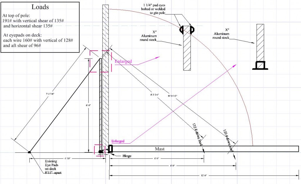
Here’s a side-view drawing of what we came up with. The mast loads of 135 and 120 pounds were measured using a digital scales with the mast in the horizontal position.

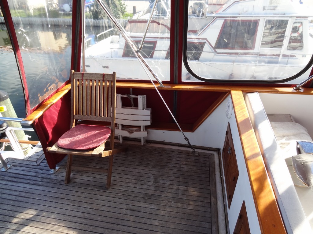
Photo 1 - Padeye and turnbuckle on deck behind bench seats port side

There are two existing pad-eyes with turnbuckles located on either side of the upper deck behind the fixed bench seats; these are normally attachment points for the mast’s forward stays. (See photo #1)

These are used to provide support for wires to the top of the gin pole.

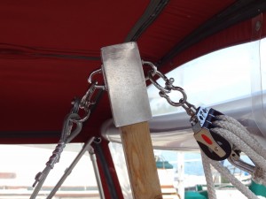
The interior dimensions of a preformed aluminum rectangular tube (provided by a friend) was almost exactly the dimension of a standard 2X4 wood stud, so instead of fabricating an aluminum gin pole, a 2X4 was used and 5 inches of one end were sanded down to fit the dimensions of the tube. A 5 inch section of the tube was cut from the stock and a plate welded across one end (a precaution that may not have been necessary). Two pad-eyes with rings were bolted to either side of the aluminum cap for attachment points. (See photo #2) Two lengths of galvanized wire-rope were cut to length and thimbles secured with wire clamps of appropriate size were added. The wire-ropes attach to the turnbuckles and to the gin pole with steel shackles.

Photo 2 - Aluminum gin pole cap with pad-eyes and rings

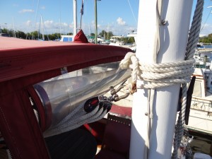
For the block and tackle we used two 3-sheave Harken 2.25 inch triple blocks with becket sized for 7/16” inch braided line rigged to disadvantage. The fixed block is attached to the top of the gin pole with a steel shackle; the traveling block is attached to the mast about mid-point with a steel shackle and a length of 1/2” line wrapped around the mast above a standard cleat attached to the aft side of the mast. (See photo 3) The fall is lead to the boat deck and is controlled from there. This allows one-person operation due to the great mechanical advantage and also allows the mast to be guided from side to side to properly lay into the crutch.

Photo 3 - Travel block attachment to mast

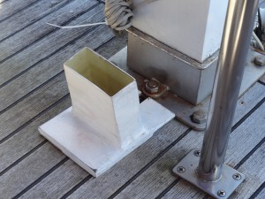
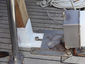
The base of the gin pole is inserted into a shoe made of fiberglass/epoxy to fit the outside dimensions of the 2X4 with a 1/2” base to fit under the nut and stud and recessed in part which helps secure the mast in an upright position in the tabernacle. (See photo 4) The base is inserted under the nut once the mast is tilted backwards slightly. (See photo 5) When the shoe was being made, several layers of paper and plastic sheet were wrapped around the end of the the 2X4 before wrapping the fiberglass in order to ensure the gin pole would easily slide in and out of the shoe to make storage and replacement easier.

Photo 4 - Shoe and tabernacle

Photo 5 - Shoe, gin pole in place and tabernacle with mast down

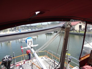
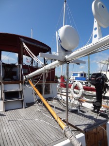
In use, the gin pole and supporting wires are assembled and the block-and-tackle tied to the mast; the forward mast stays are removed from the turnbuckle and the gin pole supporting wires are attached in their place; the base of the gin pole is located just forward of the mast tabernacle and the fixed block is attached. At this point the rig is fairly stable and will stand on its own. The pockets through which the forward stays pass in the bimini top are loosened to allow the stays to be pulled through (although they’re only pulled through when the mast is actually lowered). The nut on the tabernacle is removed and the mast tilted backward slightly with a slight amount of pull now transferred to the lowering rig. The gin pole shoe is inserted around the stud and the nut replaced and hand tightened onto the base of the shoe. The mast is then lowered a bit more until tension is placed on the rig; the operator then moves to the boat deck alongside the mast and coaxes the mast lower until the weight is held by the block-and-tackle and lowering is controlled by letting out the fall. The mast is guided into the crutch while the end of the boom lies on the deck. (See photos 6 & 7)

Photo 6 - Rig with mast down

Photo 7 - Mast laying in crutch

All materials were sized to exceed the anticipated loads by a factor of at least three.

The whole process takes about 10 minutes. Although raising and lowering the mast can be done by one person, a second person is extremely helpful in keeping everything steady and in pushing the mast backward to get the fall started. The whole rig stores in the lazarette.

Cruising the Erie Canal, the Canadian canals and through Lake Champlain into the Champlain Canal could not have been accomplished without the ability to raise and lower the mast easily. Removing the mast or permanently lowering it was not an option as we needed the ability to raise the mast once we were through the height-restricted areas in order to use the running and anchor lights and radar. This simple device made it all possible.

Getting ready!

Less than a month before departing for Canada and our list of things to accomplish before leaving is getting shorter (but still exists).

We hope to leave Merritt Island around April 27th, weather permitting. We have made some major improvements since last year: a mechanism to allow us to lower the mast to bring our air draft down from 22 1/2 feet to 15 1/2 feet (we’ll need the lower clearance in order to transit some of the canals in New York state and Canada), have purchased a new 10 foot Achilles dinghy which will be much more stable and comfortable, replaced both holding tanks and all the sanitation hose, replaced the entire house bank of batteries (10 Trojan T-105 6 volt batteries providing 1100 amps of 12 volt power), replaced all the interior incandescent 12 volt bulbs with LEDs, replaced the running and anchor light bulbs with LEDs, added additional shelving in storage spaces, and added removable side awnings, along with a lot of smaller additions and changes.

Our cruise this year will take us north on the IntraCoastal Waterway (ICW) from Florida to Norfolk, Virginia; up Chesapeake Bay, through the Chesapeake and Delaware Canal and down Delaware Bay to Cape May, New Jersey; up the New Jersey coast into the Hudson River at New York City; up the Hudson River as far as it’s junction with the Erie Canal north of Troy, New York; into the Erie Canal to the Finger Lakes west of Syracuse, then into Lake Ontario via the Oswego Canal; through the Trent-Severn Waterway to Georgian Bay and return; the Thousand Islands area at the mouth of the St. Lawrence River; the Rideau Canal to Ottawa and down the Ottawa River into the St. Lawrence Seaway to Montreal; to Sorel and the beginning of the Richelieu Canal to Lake Champlain; finally returning to the Hudson River and retracing our track to Florida! We’re estimating the total distance to be about 8,000 statute miles. Along the way we’ll be joined by family and friends who will be aboard for various lengths of time; Andrew and his family will be joining us for a month for part of the Canadian portion of the cruise.

The cats haven’t yet been told that they’ll need to put on their sea legs in a few weeks!

You can check out our blogs from previous years here:
2008 at 2008 Cruise to Bay of Fundy
2009 at 2009 Cruise to Chesapeake Bay
2010 at 2010 Cruise on the St. Johns River

Sanford to Naval Air Station, Jacksonville

While we were at Sanford, Judy rented a car and drove home to take care of some business, then returned on the morning of Thursday, June 10th. We did a little quick shopping, turned in the rental car, and then departed Monroe Harbor Marina to head downstream toward the ICW.

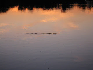
We stopped a few hours later at Hontoon Island State Park (where we had spent three nights on the way upstream) since we enjoyed that area so much. We had thought we might stop at Blue Springs Park on the way, but when we looked at the only two anchorages available we decided to bypass that park this trip. The stop at Hontoon Island State Park turned out to be an interesting one. Late in the afternoon as we were sitting topside reading we saw a strange looking bird swimming toward the island; it took a while to realize it was a juvenile sand hill crane apparently not yet able to fly swimming through the alligator-infested waters to join its parents on the island! We see sand hill cranes almost daily at our home, but had never seen one swimming. Quite an unusual site. Then, shortly after sunset, the alligators began appearing. One was obviously much larger than the others and cruised both sides of the river and then entered the area around the docks at the island where it apparently threatened a smaller ‘gator which quickly swam away. Good thing the sand hill crane had made it to shore well before the ‘gators started their nightly patrol.

The next day we continued downstream (north) to the southern end of Lake George and then turned left off the main channel to anchor near the entrance to Crystal Glen Spring Run, one of the many fresh water springs in central Florida. The afternoon was hot, and we didn’t waste much time after anchoring getting the dinghy into the water and motoring into the spring. As soon as we got near the spring’s mouth the water got clear and cooler, and after actually entering the spring we could easily see the bottom, fish swimming around, and aquatic plants of various kinds.

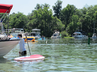
The spring originates about 3/4 of a mile to the west of Lake George’s shoreline, and near the actual spring the body of water gets a little wider with a roped-off state park at the far end. Boats of all descriptions were anchored in the very shallow area just before the source while others were pulled up on the sandy shoreline. There were a number of small house boats, kayaks, canoes, small runabouts, and various types of pontoon boats – even a guy selling hot dogs and sodas from a pontoon boat which he would frequently motor around the other boats. People were in the water talking and swimming and generally enjoying the cool spring water. As we were leaving we saw one large gar perhaps 3 feet long as well as other fish of unknown types.

That evening the wind suddenly picked up from less than 5 mph to around 15-17 mph from the south-east as we began hearing thunder in the distance. Eventually we could see the lightning in the clouds as the sun was still setting, and soon it became obvious that we were on the edge of a large thunderstorm. NOAA weather radio indicated that a severe storm was heading south – and it did as it skirted just to the west of the lake. Eventually the storm passed and the wind calmed down to nearly nothing.

Saturday morning we departed Silver Glen Springs Run and ran 37 miles to Porters Cove, about three miles south of Palatka, where we anchored for the night. We dinghied downstream 1.5 miles to the free restaurant dock at Corky Bell’s Restaurant where we met friends for dinner, and were back on Sanderling (again via dinghy) before sunset. The air was still and hot enough that we ran the generator and both air conditioning units until about 0100 the next morning in order to keep cool enough to sleep comfortably.

On Sunday we had planed to travel as far as the free restaurant dock on Six Mile Creek, just south of Green Cove Springs, to spend the night; however, due to the hot weather with temps approaching 95 we decided to stop for a late lunch at the Outback Crab Shack restaurant and continue north to Naval Air Station Jacksonville where we could be in an inexpensive marina with electricity for air conditioning. We’re glad we made that choice. The temps have been in the mid to high 90s with humidity to match, making a heat index near 105 for the past several days!

Judy is driving home Tuesday evening to work in her hospital on Wednesday.  While she’s away, Bob is going to try to fix, at least temporarily, the aft cabin air conditioner which seems to have it’s own rules about the best time to run and rest. When Judy returns on Thursday morning we’ll depart for a Jacksonville and a few nights at the Landing so we can do some more sight-seeing for a day. Then we’ll head into the ICW and south toward Merritt Island and home.